ZONING CODE
Supplementary Regulations
Sign Regulations
| 150.410 PURPOSE AND INTENT
| |
| 150.410.01 PURPOSE
| |
| 150.410.02 INTENT
| |
| 150.420 DEFINITIONS
| |
| 150.430 GENERAL PROVISION FOR ALL SIGNS
| |
| 150.440 PROHIBITED SIGNS AND LOCATIONS
| |
| 150.450 DESIGN STANDARDS
| |
| 150.460 EXCEPTIONS TO SIGN REGULATIONS
| |
| 150.470 TEMPORARY/PORTABLE SIGN REGULATIONS
| |
| 150.470.01 REAL ESTATE SIGNS
| |
| 150.470.01.01 RESIDENTIAL ZONES
| |
| 150.470.01.02 AGRICULTURAL/COMMERICAL/INDUSTRIAL ZONES
| |
| 150.470.02 SPECIAL EVENT SIGNS
| |
| 150.470.03 POLITICAL CAMPAIGN SIGNS
| |
| 150.470.04 GARAGE SALE SIGNS
| |
| 150.470.05 SUBDIVISION CONSTRUCTION SIGNS
| |
| 150.470.06.01.01 LOCATED IN STAND ALONE STRUCTURES
| |
| 150.470.06.01.02 LOCATED WITHIN SHOPPING CENTERS
| |
| 150.470.06.02 SHORT TERM BUSINESSES (SEE DEFINITIONS)
| |
| 150.470.07 STREET BANNERS
| |
| 150.470.08 INTERIM SIGNS PENDING PERMANENT SIGN:
| |
| 150.480 PERMANENT SIGN REGULATIONS
| |
| 150.480.01 RESIDENTIAL DISTRICTS
| |
| 150.480.01.01 HOME IDENTIFICATION SIGNS
| |
| 150.480.01.02 SUBDIVISION/COMPLEX IDENTIFICATION SIGNS
| |
| 150.480.02 COMMERCIAL DISTRICTS
| |
| 150.480.02.01 A-1/AGRICULTURAL/LOWDENSITY RESIDENTIAL DISTRICT & C-1/NEIGHBORHOOD COMMERCIAL DISTRICT
|
| 150.480.02.01.01 LOCATED IN STAND ALONE STRUCTURES
| |
| 150.480.02.01.01 LOCATED WITHIN SHOPPING CENTERS
| |
| 150.480.02.02 C-2/GENERAL COMMERCIAL DISTRICT
| |
| 150.480.02.02.01 LOCATED IN STAND ALONE STRUCTURES
| |
| 150.480.02.02.02 LOCATED IN SHOPPING CENTER
| |
| 150.480.03 INDUSTRIAL DISTRICTS
| |
| 150.480.03.01 I-1/LIGHT INDUSTRIAL/HEAVY COMMERCIAL
| |
| 150.480.03.02 I-2/HEAVY INDUSTRIAL
| |
| 150.480.04 OFF PREMISES SIGNS
| |
| 150.480.05 SIGN REGULATIONS FOR CONTINGENT/SPECIAL USES
| |
| 150.490 SIGN PERMIT PROCEDURES
| |
| 150.495 VARIANCES
| |
| 150.497 SIGN PERMIT FEES
| |
| 150.500 PENALTY
| |
Non-conforming Structures and Uses
Administration and Enforcement
Floodplain Management
| 150.710 Statutory Authorization, Findings of Fact, Purpose, Objectives and Floodplain Overlay Districts
|
Wetlands Conservation
| 150.850 Board of zoning appeals
|
Sexually Oriented Businesses
| | |
| GENERAL PROVISIONS AND PURPOSE
|
| | |
| 150.110 SHORT TITLE
|
| This chapter shall be known as the "Auburn Zoning Code".
|
| | |
| 150.120 PURPOSE AND BASIC PROVISIONS OF CHAPTER
|
| A)
| Master Plan |
| The zoning regulations and zone districts as herein set forth are made in accordance with a master plan to promote the public health, safety, morals, convenience, and general welfare of the community; to insure that adequate population densities, light, air, convenience of access, and safety from fire, flood, and other dangers may be secured; that congestion in the public streets, roads and rights-of-way may be lessened or avoided; to facilitate adequate provision for a system of transportation, sewage disposal, safe and adequate water supply, education, recreation, and other public needs; and to conserve the expenditure of funds for public improvements and services to conform with the most advantageous uses of land, resources, and properties.
|
| B)
| Authority |
| This chapter is adopted pursuant to IC 36-7-4 et seq. and all acts supplemental and amendatory to it.
|
| C)
| Compliance |
| No buildings, dwellings, structures, or land shall hereafter be used; and no building, dwelling, structure, or part thereof shall be erected or moved unless in conformity with the regulations of this chapter.
|
| D)
| Severability |
| If any subchapter, section, clause, provision, or portion of this chapter shall be held to be invalid or unconstitutional by any court of competent jurisdiction, such decision shall not affect any other subchapter, section, clause, provision, or portion of this chapter.
|
| E)
| Jurisdiction |
| The jurisdiction of this chapter shall include lands and waters of the incorporated area of the city. All buildings erected, all uses of land or buildings established, all structural alterations or relocations of buildings, and all enlargements of or additions to uses occurring after adoption of this chapter shall be subject to all provisions of this chapter which are applicable to the zoning districts in which those buildings, uses, land, or waters shall be located.
|
| F)
| Application |
| This chapter is not intended to interfere with, abrogate, or amend any easements, covenants or other agreements existing prior to adoption. This chapter is not intended to repeal, abrogate, annul, or in any way interfere with any provisions of laws or ordinances existing prior to adoption; or any rules, regulations or permits adopted or issued prior to law before that date relating to the use of buildings or premises.
|
| G)
| Restrictive standards |
| 1)
| Whenever the provisions of this chapter are more restrictive, or impose higher standards than are required by any state statute, or any provision of any other provision of this Code of Ordinances, or of any other ordinance of this city, or by any restrictions or limitations as to particular property established by deed, plat, or otherwise running with the land, the provisions of this chapter shall govern. |
| 2)
| Whenever the provisions of any state statute, or of any other ordinance of this city, or any restriction or limitation established by deed, covenant, plat, or otherwise running with the land, are more restrictive, or impose higher standards than are required by this chapter, the provisions of such statute, ordinance, chapter, deed, covenant, plat, restriction, or limitation shall govern. |
| | |
| | |
| 150.130 RULES OF CONSTRUCTION
|
| For the purpose of this chapter, certain words and phrases used herein shall be interpreted as follows:
|
| A)
| The word "PERSON" includes an individual, firm, association, organization, partnership, trust, company, corporation, unit of government or any other legal entity. |
| B)
| The masculine includes the feminine. |
| C)
| Words used in the present tense include the past and future tense; the singular tense includes the plural, and the plural, the singular. |
| D)
| The word "SHALL" is a mandatory requirement, the word "MAY" is a permissive requirement, and the word "SHOULD" is a preferred requirement. |
| E)
| The words "USED" or "OCCUPIED" include the words "intended, arranged, or designed to be used or occupied". |
| F)
| Unless otherwise specified, all distances shall be measured horizontally in any direction. |
| | |
| | |
| | |
| 150.140 INTERPRETATION OF THE ZONING MAP
|
| Where, due to the scale, lack of detail, or illegibility of the zoning map, there is an uncertainty, contradiction, or conflict as to the intended location of any zoning district boundary as shown thereon, the Administrator/Zoning Administrator shall make an interpretation of said map upon the request of any person. Any person aggrieved by such interpretation may appeal such interpretation to the Board of Zoning Appeals. The Administrator/Zoning Administrator and the Board of Zoning Appeals, in interpreting the zoning map or deciding any appeal, shall apply the following standards:
|
| A)
| Zoning district boundary lines are intended to follow lot lines, or be parallel or perpendicular thereto, or along the centerline of alleys or streets, or along water courses, contour lines, or other similar established lines. |
| B)
| Where zoning district boundary lines are so indicated that they approximately follow lot lines, such lot lines shall be construed to be such boundary lines. |
| C)
| Where a zoning district boundary line divides a lot, the location of any such zoning district boundary line, unless indicated by dimensions shown on the zoning map, shall be determined by the use of the map scale shown thereon. |
| D)
| If, after the application of the foregoing rules, uncertainty still exists as to the exact location of a zoning district boundary line, or the physical or cultural features existing on the ground are at variance with those shown on the official zoning map, the boundary line shall be determined in a reasonable manner considering the history of uses of property and history of zoning ordinances and amendments in the city as well as all other relevant facts. |
| | |
| | |
| 150.150 DEFINITIONS
|
| For the purpose of this chapter, the following definitions shall apply unless the context clearly indicates or requires a different meaning.
|
| ABANDONED
|
| The relinquishment of property or a cessation of the use of the property for a continuous period of time by the owner with the intention of not transferring rights to the property to another owner nor of resuming the use of the property.
|
| For an abandonment of use to take place there must be evidence that through an affirmative act, the owner’s intent is not to continue the existing non-conforming use or that physical or structural changes have been made to the existing use that demonstrates that a change in use took place.
|
| a)
| In the case of a legal non-conforming land use, a cession of use of the property is for a period of one (1) year. |
| b)
| In the case of a legal non-conforming structure, a cession of use of the property is for a period of three (3) years. |
| ACCESSORY LIVING QUARTERS
|
| Living quarters, with an accessory, for the sole use of persons employed on the premises; such quarters having no kitchen facilities and not rented or otherwise used as a separate dwelling.
|
ACCESSORY STRUCTURE
A structure that is subordinate to a primary structure in area, intent, and/or purpose; contributes to the comfort, convenience, or necessity of the occupants of the primary structure; does not alter or change the character of the property; and is located on the same lot as the primary structure.
ACCESSORY USE
A use that is secondary to a primary use in area, intent, and/or purpose; contributes to the comfort, convenience, or necessity of the occupants of the primary use; does not alter or change the character of the property; and is located on the same lot as the primary use. In no event shall a lot which is not contiguous to the principal use be considered an accessory use.
ADMINISTRATOR (Department Head)
The Administrator of the Department of Building, Planning and Development of the City of Auburn, or the Administrator’s designated representative.
| ALLEY
|
| Right-of-way other than a street, road, crosswalk, or easement, designed for the special accommodation of the property it reaches.
|
| | |
| AMORTIZATION
|
| The process of discontinuing nonconforming land uses.
|
| | |
| APARTMENT
|
A dwelling unit in a structure designed, intended, occupied on a rental basis for housing of a single-family, an individual, group of individuals, or other single housekeeping unit.
APPLICANT
The fee simple owner(s) of land or owners’ legal representative(s) who makes application to the Auburn Department of Building, Planning, and Development Office for action by the City of Auburn boards, commissions, and other entities, thereby affecting that land.
| 1)
| AREA, BUILDING |
| The total of areas taken on a horizontal plane at the main grade level of the principal building and all accessory buildings, exclusive of uncovered porches, terraces, and steps.
|
| | |
| 2)
| AREA, NET SITE |
| The total area within the property lines of a project, excluding external streets.
|
| BASEMENT
|
| A story partly underground but having at least one-half of its height below the average level of the adjoining ground. A basement shall be counted as a story for the purposes of height measurement if the vertical distance between the ceiling and the average level of the adjoining ground is more than five feet or if used for business or dwelling purposes.
|
BED AND BREAKFASTS-OWNER OCCUPIED
A small establishment, having one to five guest rooms for rent or lodging to transient guests, providing for occasional meals, and in which the owner also resides. These are generally treated as tourist homes not hotels, motels or boarding houses and not intended for long term stays beyond 30 days.
BED AND BREAKFASTS-NONOWNER OCCUPIED
A small establishment, having one to five guest rooms for rent or lodging to transient guests, providing for occasional meals, and in which the owner does not reside. These are generally treated as tourist homes not hotels, motels or boarding houses and not intended for long term stays beyond 30 days.
BED AND BREAKFAST INNS
Establishments ranging up to twenty guestrooms and may include restaurants that cater to the general public as well as the overnight guests. These are treated as commercial enterprises.
Property abutting on one side of a street and lying between the two nearest intersecting or intercepting streets, or nearest intersecting street, and intersecting railroad right-of-way end of dead-end street, public park, cemetery or city boundary line and not exceeding 1320 feet in length.
| BOARD
|
| The Board of Zoning Appeals of the city.
|
A structure having a roof supported by columns or walls designed, built, or used for the enclosure, shelter, or protection of persons, animals, or property.
| 1)
| BUILDING, DETACHED |
| A free-standing building having no structural connection with another building.
|
| 2)
| BUILDING, HEIGHT OF |
| Where the front of the building is contiguous to the street right-of-way line, the vertical distance measured from the adjoining street centerline.
|
| 3)
| BUILDING, MAIN OR PRINCIPAL |
| The building which constitutes the principal use of a lot.
|
| 4)
| BUILDING, NONCONFORMING |
| A building, lawfully existing at the time this chapter became effective, which will require compliance with the regulations set forth in this chapter, applicable to the district in which such building is located.
|
| 5)
| BUILDING, SEMI-DETACHED |
| A main building having one wall in common with the adjacent main building.
|
BUILDING PERMIT
An official certification issued by the Administrator (Department Head) authorizing the construction, alteration, enlargement, conversion, reconstruction, remodeling, rehabilitation, erection, demolition, moving, or repair of a building or other structure.
| BUILDING MATERIAL DEMOLITION
|
| A site designed for the purpose of disposing building materials from a demolition site or sites without creating nuisances or hazards to public health, safety, or welfare.
|
| BUILDING, SETBACK LINE
|
| The line, established by this chapter, which a building shall not extend beyond unless such line is varied according to procedures in this chapter. Also called a "BUILDING LINE." This may be applicable to the front, side, and/or rear yard.
|
BUSINESS
The engaging in the purchase, sale, or exchange of goods, merchandise, or services, or the maintenance or operation of offices, recreational or amusement enterprises, by either profit or not-for-profit entities.
| CARPORT
|
| A shelter for one or more vehicles which is not fully enclosed by walls.
|
| | |
| CAR WASH
|
| A lot on which motor vehicles are washed or waxed, either by the patron or by others, using machinery specially designed for such purpose.
|
| | |
CELLULAR COMMUNICATION EQUIPMENT (Towers)
Antennas, towers, and other transmitting and/or receiving devices or communication equipment providing telecommunication services.
| CEMETERY
|
| Land used for the burial of the dead and dedicated for cemetery purposes, including columbarium, crematories, mausoleums, and mortuaries when operated in conjunction with, and within the boundary of, such cemetery.
|
| | |
| CERTIFICATE OF OCCUPANCY
|
A certificate issued by the Administrator(Department Head) stating that the occupancy and use of land or building or structure referred to therein complies with all applicable provisions of the City of Auburn codes and ordinances.
CHILD CARE FACILITY
Custodial recreational or institutional care, designed to supplement parental care, given children (other than the providers), who are under eleven (11) years old. Child care facilities are either licensed by the State or exempted from licensing requirements. Child Care does not include: public or parochial schools, day camps, summer camps, foster homes, group homes or cooperative reciprocating care by a group of parents in their own homes (See CHILD CARE CENTER, CHILD CARE HOME).
CHILD CARE CENTER
A State licensed (or exempted) facility in a nonresidential structure where one or more individuals provide child care for six (6) or more children at any time.
CHILD CARE HOME
A State licensed (or exempted) facility in a residential structure where one or more individuals provide child care for six (6) to (10) children, for more than four hours but less than twenty-four hours, for ten or more consecutive working weekdays. The structure shall be occupied as a residence.
| CHURCH
|
| A building wherein persons regularly assemble for religious worship which is used only for such purpose and those customarily associated accessory activities.
|
| | |
| CLINIC, MEDICAL OR DENTAL
|
| An establishment where patients are admitted for special study and treatment by two or more licensed physicians and their professional associates, engaged in the active practice of medicine.
|
| | |
| COMMISSION
|
| The Auburn Plan Commission.
|
| | |
| CONDOMINIUM
|
Real estate lawfully subjected to IC 32-25 et seq (the Horizontal or Condominium Property Law) by the recordation of condominium instruments, in which undivided interests in the common areas and facilities are vested in the condominium unit owners.
| CONVENIENCE STORE
|
| A retail store under 10,000 square feet providing general grocery merchandise; it may also provide automobile gasoline.
|
| | |
| COVENANT (DEED RESTRICTION)
|
| A private legal restriction on the use of land contained in the deed to the property. Normally applied to all lots in any subdivision.
|
| | |
| CUL-DE-SAC STREETS
|
| A dead end street that terminates in a circular right-of-way and does not provide more than one access point onto another street, or means of access to lots not fronting thereon, nor act as a collector.
|
| DAY CARE CENTER
|
| See Child Care Center.
|
DEPARTMENT
The Department of Building, Planning, and Development of the City of Auburn, Indiana.
DETACHED BUILDING
A building that has no structural connection with another building.
| DEVELOPMENT PLAN
|
| A plot plan, and supporting information, delineating the location and characteristics of structures, vehicular, and pedestrians’ areas, utilities, storm water drainage, signage, landscaping, and other accessory facilities to be constructed, modified or reconstructed on a parcel or parcels of real estate.
|
| DISTRICT OR ZONE
|
| A section of the jurisdictional area of the city for which uniform regulations governing the use, height, area, size, and intensity of use of buildings and land, and open spaces about buildings, as established by this chapter.
|
A building or part of a building that is used primarily as a place for residential purposes of a family or household unit excluding hotels, motels, lodging houses, boarding houses, or/and tourist homes.
| 1)
| DWELLING, MULTIPLE-FAMILY |
| A dwelling or portion thereof used for occupancy by two or more families living independently of each other.
|
| 2)
| DWELLING, MULTIPLE-GROUP |
| A group of two or more multiple dwellings occupying a parcel of land in common ownership and having any yard, court, compound, or service in common.
|
| 3)
| DWELLING, SINGLE-FAMILY |
| A building used for occupancy by one family.
|
| DWELLING UNIT
|
| A dwelling or portion of a two-family or multiple-family or of an apartment used by one family for cooking, living, and sleeping purposes.
|
| | |
| EASEMENT
|
| An authorization grant made by a property owner for use by another of any designated part of his property for a clearly specified purpose and officially recorded.
|
| 1)
| EASEMENT, ROADWAY |
| A roadway approved by the Commission over private property which permits a specific and limited use of that thoroughfare to the grantee of the easement.
|
| 2)
| EASEMENT, UTILITY AND SERVICE |
| A portion or strip of land which is part of a lot or parcel but which has been reserved for the specific purpose of utilities and related services.
|
| | |
| EDUCATIONAL INSTITUTION
|
| Pre-primary, primary or grade, public, parochial or private school, high school preparatory school or academy, public or founded or owned or conducted by or under the sponsorship of a religious or charitable organization; private preparatory school or academy furnishing courses of instruction substantially equivalent to the courses offered by public high school for preparation of admission to college or university, public or founded or conducted by or under the sponsorship of a religious or charitable
|
| organization, or private when not conducted as a commercial enterprise for the profit of individual owners or stockholders. This definition shall not be deemed to include trade or business school as defined in this chapter.
|
| | |
| FAMILY
|
An Individual or two or more persons related by blood, marriage, or adoption, or a group of not more than three unrelated persons living as a single housekeeping unit in a dwelling unit.
| FENCE
|
| A structure, including entrance and exit gates, designed and constructed for enclosure and screening.
|
| FLOOD HAZARD AREAS
|
| Means those floodplains which have not been adequately protected from flooding by the regulatory flood by means of dikes, levees, reservoirs, or other works approved by the state and whose lateral extent is or shall be determined from the combined height of the
|
| regulatory flood profile together with freeboard. The boundaries of this area shall be the flood hazard area as determined when required and from time to time, and from the best available engineering maps flood profiles, hydraulic information and the like.
|
| FLOOD PROTECTION GRADE
|
| Means the elevation of the lowest point around the perimeter including the basement of a building at which floodwater may enter the interior of the building.
|
| FLOODPLAIN
|
| The area adjoining a river or stream which has been or may hereafter be covered by flood water as established from data supplied by the Division of Water of the State Department of Natural Resources.
|
| | |
| FLOODWAY (FW) OR REGULATORY FLOODWAY
|
| Means the channel of a river or stream and its adjoining areas as defined and regulated by the state, which are those portions of the floodplain adjoining the channel which are reasonably required to efficiently carry and discharge the peak flood flow of the regulatory flood of any river or stream.
|
| GARAGE, PRIVATE
|
| A detached accessory building or a portion of a main building, used as an off-street parking area or for the storage of self-propelled vehicles.
|
| GARAGE, PUBLIC
|
| Any building or structure other than a private garage, and which is used for storage, repair, rental, greasing, washing, servicing, adjusting or equipping of automobiles or other motor vehicles.
|
| | |
| GROSS LEASABLE FLOOR AREA
|
| The total floor area of a structure designed for tenant occupancy and exclusive use, including basements, mezzanines and upper floors, if any, expressed in square feet and measured from outside wall faces.
|
GROUP HOMES (Developmentally Disabled)
Means a facility as described by IC 12-28-4-8 that houses not more than eight persons who are developmentally disabled. This group home shall abide by IC 12-11-1.1 and shall be a licensed facility with the State, meeting fire codes building codes, and specific group home regulations (Also referred to as group care homes).
GROUP HOMES (Mentally Ill)
Means a facility as described by IC 12-28-4-7 that houses not more than 15 persons who are mentally ill. This group home shall abide by IC 12-22-2-3 (2) through (6) and shall be a licensed facility with the State, meeting fire codes building codes, and specific group home regulations (Also referred to as group care homes).
GROSS FLOOR AREA
The total floor area of all stories of a building or buildings, measured at the outside foundation. Public or common mall areas, such as an open air or outside covered passageway or concourse providing access to rows of stores, shall be excluded from the definition of gross floor area.
| | |
| HAZARDOUS WASTES
|
| Any solid or liquid waste with inherent dangers, including but not limited to, toxic chemicals, explosives, pathological wastes, radioactive materials, materials likely to cause fires, liquids, semi-liquids, sludge containing less than 30% solids, pesticides, pesticide containers, raw animal manure, septic tank pumping, and raw or digested sewage sludge.
|
| | |
| HOME OCCUPATION
|
| A gainful occupation or profession conducted entirely within a dwelling and carried on only by an occupant or an occupant's family residing in that dwelling, provided that non-residential use is only incidental to the primary use. Occupations can be located on any floor level and shall not exceed an area equivalent to 25% of ground floor area of structure, occupational use shall be carried out indoors in principal building, shall be no exterior evidence of the occupation except for a small announcement sign in accordance with sign regulations specified in 150.410 et seq.
|
| HOME WORKSHOP/BUSINESS
|
| A gainful occupation or profession conducted entirely within a dwelling, or in an accessory building, located on the same lot, parcel, or tract of land as the dwelling, and carried on by an occupant or an occupant's family residing in that dwelling and by no more than two employees, associates or partners who are not members of the family, which use is clearly incidental and secondary to the use as a dwelling.
|
| HOTEL OR MOTEL
|
| A building, group of buildings, or portion thereof, in which more than five guest rooms are provided as temporary accommodations for compensation to transient guests.
|
| | |
HOUSEKEEPING UNIT
A group of individuals functioning as a single household, making common use of a single kitchen and other household quarters.
| IMPROVEMENT LOCATION PERMIT
|
Written permission issued by the Administrator/Zoning Administrator to allow a person, firm, or corporation to erect, construct, enlarge, alter, repair, move, improve, remove, convert, demolish, or add to any building or structure within its jurisdiction, or cause the same to be done or change the use or condition of the land and that is subject to the requirements of the City of Auburn Zoning Ordinance and Subdivision Control Ordinance.
| | |
| | |
| JUNK
|
| Old scrap copper, brass, rags, batteries, paper, trash, rubber debris, waste or junked, dismantled, abandoned or wrecked motor vehicles or parts of them, iron, steel and other old or scrap ferrous or non-ferrous materials.
|
| JUNKYARD
|
| A place, usually outdoors, where waste or discarded used property other than organic matter, including but not limited to automobiles, farm implements and trucks, is accumulated and is or may be salvaged for refuse or resale; this shall not include any industrial scrap metal processing facilities.
|
| JURISDICTIONAL AREA
|
| For planning and zoning, the area incorporated within the city, and any other unincorporated territory legally under the jurisdiction of the City Plan Commission.
|
A lot, building, structure, enclosure or premises whereon or wherein 5 or more dogs or cats or other domestic animals over the age of 6 months are raised, maintained, boarded, bred, kept or cared for in return for remuneration, or are kept for the purpose of sale or are groomed, trained or handled for others.
| LIVING SPACE
|
| The area within a structure intended, designed, erected, or used for human occupancy.
|
| | |
| LOT
| |
| A parcel of land occupied or to be occupied by a building and its accessory buildings and/or uses or by group dwellings and their accessory buildings, together with such open spaces as are required under the provisions of this chapter, having at least the minimum area required by these regulations for a lot in the zone in which such lot is situated and having its principal frontage on a public street or public way or a recorded private easement in a form approved in writing by the Plan Commission.
|
| 1)
| LOT, CORNER |
| A lot abutting two or more public streets at their intersection where the interior angle of intersection does not exceed 135 degrees.
|
| 2)
| LOT COVERAGE |
| The percentage of the lot area covered by the building area.
|
| 3)
| LOT, DEPTH OF |
| The distance between the mid-points of straight lines connecting the foremost points of the side lot lines in front, and the rearmost points of the side lot lines in the rear.
|
| 4)
| LOT, GROUND LEVEL OF |
| a)
| For buildings adjoining only one street, the elevation of the ground shall be measured at the center of the yard adjoining the street. |
| b)
| For buildings having yards adjoining more than one street, the average elevation of the ground shall be measured at the center of all yards adjoining the streets. |
| c)
| For buildings having no yards adjoining the street, the average level of the ground shall be measured adjacent to the exterior walls of the building. |
| 5)
| LOT, INTERIOR |
| A lot with only one frontage on a street.
|
| 6)
| LOT, THROUGH |
| A lot having frontage on two parallel or approximately parallel streets and which is not a corner lot.
|
| LOT LINES
|
| Lines bounding a lot, as follows:
|
The line running along the front of the lot and separating it from the street. In these regulations, the front lot line is called the "FRONT STREET LINE".
The lot line generally opposite or parallel to the front street line, except in a through lot. If a rear lot line is less than ten feet long or the lot comes to a point at the rear, said rear lot line is assured to be a line at least ten feet long, lying wholly within the lot, parallel to the front street line or parallel to the chord of the arc of said front street line.
| 3)
| LOT LINE, SIDE |
| Any lot line other than a front street line or a rear lot line. A side lot line separating the lot from a street is a "SIDE STREET LINE".
|
| 4)
| LOT, WIDTH OF |
| The width measured along the front lot line, street line, or setback line.
|
| | |
| LOT OF RECORD
|
| A lot in a subdivision plot which has been recorded in the County Recorder's Office, or in a previously existing lot at the time this chapter was adopted, described by metes and bounds, and the deed has been recorded in the County Recorder's Office.
|
| MANUFACTURED HOME
|
| A dwelling unit fabricated in an off-site manufacturing facility for installation or assembly at the building site, bearing a seal certifying that it is built in compliance with the Federal Manufactured Housing Construction and Safety Standards Code or Indiana Public Law 360, Acts of 1971. Such a unit shall also meet all of the following conditions:
|
| | 1)
Contain at least 950 square feet of occupied space per dwelling unit; be a double- section or multi-section manufactured housing unit; and has a pitched roof with a minimum rise of 2/12.
|
| 2)
| Be constructed after January 1, 1981; |
| 3)
| Be placed onto a permanent under floor foundation installed in conformance with the Indiana One- and Two-Family Dwelling Code or the Indiana Uniform Building Code in the case of multi-family dwelling units, and the manufacturer's installation specifications; |
| 4)
| Be placed onto a permanent perimeter enclosure constructed in accordance with the Indiana One- and Two-Family Dwelling Code or the Indiana Uniform Building Code in case of multi-family dwelling units; |
| 5)
| Have wheels, axles, and hitch mechanisms removed; |
| 6)
| Have siding material of a type customarily used on site-constructed residences; |
| 7)
| Have roofing material of a type customarily used on site-constructed residences. Roofing material shall be installed in accordance with the manufacturer's specifications. |
| MASTER PLAN
|
| The complete plan or any of its parts for the orderly development of the city as prepared by the Commission and adopted in accordance with IC 36-7-4 et seq., and all acts amendatory thereto, as is now or may hereafter be in effect.
|
| | |
| MOBILE HOME
|
| A dwelling unit fabricated in an off-site manufacturing facility for installation or assembly at the building site and which is designed to be used as a year-round residential dwelling. A mobile home shall be installed in conformance with the Indiana One- and Two-Family Dwelling Code.
|
| | |
| MOBILE HOME PARK
|
A site with required improvements and utilities containing two (2) or more mobile home park/manufactured home park lots, which may include services and facilities for its residents, and within which recreational vehicles and tents shall not be used as places of abode.
MULTI-FAMILY DWELLING
A building or buildings on a separate lot, containing more than two residential dwelling units.
ONE AND TWO FAMILY DWELLING CODE, INDIANA
The nationally recognized model building code adopted by the Indiana Department of Fire Prevention and building Safety as mandated by 675 I.A.C 14, and which includes those supplements and amendments promulgated by this agency.
| NET OPEN SPACE
|
| The area of a lot excluding all public and private rights-of-way.
|
| NURSING OR CONVALESCENT HOME
|
| Any dwelling with sleeping rooms where persons are housed or lodged and furnished with meals and nursing care for hire.
|
| OPEN SPACE
|
| An unoccupied space open to the sky on the same lot with a building.
|
| OWNER
|
| A person holding any legal, equitable, optional, or contractual interest in land.
|
| PARKING AREA, PUBLIC
|
| An open area, other than a street or alley, designed for use, or used, for the temporary parking of more than four motor vehicles (when available for public use), whether free or for compensation, or as an accommodation for clients or customers.
|
| | |
| PARKING SPACE (OFF STREET)
|
A unified space, other than on a street or alley, designed for use, or used, for the temporary parking of a motor vehicle, containing no less than 180 square feet exclusive of passageways on private residential property.
| PERSON
|
| A corporation, firm, partnership, association, organization, unit of government, or any other group that acts as a unit, as well as an individual person.
|
| | |
| PLANNED UNIT DEVELOPMENT
|
A development in which the developer wishes flexibility of district regulations governing lot size, yards, setbacks, and building location or size that meet the requirements for zoning approval. A planned unit development may be a subdivision which is being developed as a unit under single ownership or control whose intent is to sell individual lots or estates, whether fronting on private or dedicated streets.
| PUBLIC UTILITY
|
| Any person, firm, corporation, municipal department, or board fully authorized to furnish and furnishing under state or municipal regulations to the public, electricity, gas, steam, telephone, telegraph, transportation or water.
|
| | |
| RECREATIONAL SPACE
|
| The area of a lot devoted to recreational purposes.
|
| 1)
| RECREATIONAL SPACE, DEVELOPED |
| Recreational space which contains Commission-approved site improvements including but not limited to shelters, swimming pools, tennis courts, lakes and playground fixtures, among others.
|
| 2)
| RECREATIONAL SPACE, UNDEVELOPED |
| Recreational space which is void of buildings and/or structures.
|
A temporary dwelling for travel, recreation and vacation use including, but not limited to, travel trailer, pick-up coach, motor home, and camping trailer which is designed to be used for sleeping and human habitation.
RESIDENTIAL CARE
Establishments engaged in the provision of residential, social, and personal care for persons who require some level of care, but medical care is not the major need. These persons include those who demonstrate limits to ability for self-care such as children, the aged, the destitute, the deaf, the blind, the mentally handicapped, and physically handicapped. These establishments do not include child care centers, child care homes, or group homes which have separate definitions in this section.
| | |
| | |
| RIGHT-OF-WAY, PRIVATE
|
| A street, alley, parking lot, or other thoroughfare, or easement permanently established for the passage of persons or vehicles on a private lot, parcel or tract of land.
|
| RIGHT-OF-WAY, PUBLIC
|
| A public street, alley, or other thoroughfare or easement permanently established for the public passage of persons or vehicles.
|
| | |
| SANITARY LANDFILL
|
| A method of disposing of refuse on land without creating nuisances and hazards to public health, safety, and welfare by utilizing principles of engineering and other practices to confine the refuse to the smallest practical volume, covering it with a layer of suitable cover at the conclusion of each day's operation (or at more frequent intervals as necessary) and is operated in compliance with all federal and state environmental regulations and this chapter.
|
| SETBACK
|
| A line parallel to and equidistant from the relevant lot line or right-of way line (front, back, side) between which no buildings may be erected as prescribed in this ordinance
|
SINGLE-FAMILY DWELLING
A building or buildings, on a separate lot, containing one residential dwelling unit.
SIGN
A visual device or structure used for advertising, display, or publicity purposes.
STORAGE
Permanent: The keeping of items for sale (Retail or Wholesale), the products of manufacturing, materials used in production, vehicles, and other similar materials and/or equipment in an area outside of any building.
| STORAGE
|
| Temporary: The outdoor storage of items for retail sale that are, by their nature, sold during a peak season, such as fruits and vegetables, Christmas trees, landscaping materials, lawn accessories, and bedding plants
|
| STORY
|
The portion of a building included between the surface of any floor and the surface of the floor next above, or, if there is no floor above it, then the space between any floor and the ceiling next above it; also, any portion of a building used for human occupancy between the topmost floor and the roof. A basement shall not be counted as a story unless the height of the surface of the first floor above the average elevation of the finished lot grade at the front of the building exceeds five feet.
| 1)
| STORY HALF |
| A story under a gable, hip or gambrel roof, the wall plates of which on at least two opposite exterior walls are not more than two feet above the floor of such story.
|
| 2)
| STORY, HEIGHT OF |
| The vertical distance from the top surface of one floor to the top surface of the floor next above. The height of the top story is the distance from the top surface of the floor to the top of the ceiling joists.
|
| | |
| | |
| STREET (ROAD)
|
| A public way established or dedicated by duly recorded plat, deed, grant, governmental authority or by operation of law for the purposes of vehicular traffic.
|
| 1)
| COLLECTOR STREET |
| Collector streets are those streets which carry traffic from residential neighborhoods to the major streets.
|
| 2)
| FREEWAY/HIGHWAY |
| A term applied to streets and roads that are under the jurisdiction of the Federal Highway Administration or Indiana Department of Highways.
|
| 3)
| LOCAL |
| A system of streets and roads which primarily provides access to residential and other abutting property.
|
| 4)
| MAJOR STREET |
| A term applied to heavily used arterial streets which are part of the city's grid system for traffic circulation.
|
| 5)
| PERIMETER |
| Any existing street on which the parcel of land to be subdivided abuts on only one side.
|
| 6)
| PRIVATE |
| A local street that is neither accepted nor offered for public use or maintenance, which provides vehicular and pedestrian access.
|
| STREET LINE
|
| The dividing line between the street and the lot.
|
STRUCTURAL ALTERATION
Any change in the supporting members of a building, such as bearing walls, partitions, columns, beams, or girders, or in the dimensions or in change of square footage of living space or configurations of the roof or exterior walls.
| STRUCTURE
|
| Anything constructed or created which provides location in or on the ground or attached to something having a location in or on the ground.
|
| | |
| SUBDIVISION
|
| The division of any parcel of land, after the enactment of this chapter, shown as a unit, as part of a unit or as contiguous units on the last preceding transfer of ownership thereof into two or more parcels or lots, any one of which is less than five acres in area, in any 12-month period of time for the purpose, whether immediate or future, of transfer of ownership, or improvement of one or more of the lots or parcels of land for residential, commercial, or industrial structures or groups of structures. All division of land meeting the above described definition shall have, after the enactment of this chapter, a plat recorded in the office of the County Recorder. Said plat shall comply with all provisions of this chapter and any amendments hereto.
|
Any structure containing water and used for recreational purposes, (having any dimensions in width or diameter of greater than six feet) and built to maintain a water level greater than 24 inches in depth. This includes but is not limited to in-ground pools, aboveground pools, inflatable pools, wading pools, hot tubs and spas and shall be considered an accessory structure or use.
A building in which one but not more than five guest rooms are used to provide or offer overnight accommodations for transient guests, with or without occasional eating accommodations . (See Bed and Breakfast, Owner Occupied or Non-owner Occupied)
| TRADE OR BUSINESS SCHOOL
|
| Secretarial school or college, business school or college when not public and not owned or conducted by or under the sponsorship of a religious or charitable organization, school conducted as commercial enterprise for teaching instrumental music, dancing, barbering, martial arts or hair dressing or for teaching industrial skills in which machinery is employed as a means of instruction. This definition shall not be deemed to include educational institution as defined in this chapter.
|
| | |
| UNIT
|
| For the purpose of the Zoning and Subdivision Ordinances, a unit is defined as an existing parcel of land not previously subdivided or platted (A parcel of land that stands by itself).
|
| USE
| |
| The employment or occupation of a building, structure or open land for a person's service, benefit or enjoyment.
|
| 1)
| USE, CONTINGENT |
| The authorization of a use that is essential or desirable to the public convenience or welfare but is not necessarily a permitted use and will not be detrimental to the surrounding area.
|
| 2)
| USE, NONCONFORMING |
| The authorization of a use that is lawful prior to the adoption of the Zoning
|
| Ordinance or by amendments that may later be adopted but would be prohibited, regulated or restricted under the terms of the Zoning Ordinance or future amendments. |
| 3)
| USE, OPEN |
| The use of a lot without a building, or including a building incidental to the open use with a ground floor area equal to 5% or less of the area of this lot.
|
| 4)
| USE, PERMITTED |
| A use that is allowed, as of right, within a certain space.
|
| 5)
| USE, SPECIAL |
| The authorization of a use that is designated as such by this ordinance as permitted in the district concerned, if it meets special conditions, and upon application, is specifically authorized by the Board of Zoning Appeals.
|
A specific approval granted by the Board of Zoning Appeals in the manner prescribed by the Zoning Ordinance, to deviate from the zoning and development plan design standards (such as, yard setbacks, height, lot area, etc.) that the Zoning Ordinance otherwise prescribes.
| | |
| VEHICLE STORAGE YARD
|
| Any establishment or place of business which is maintained or operated or used for the storage of motor vehicles which may or may not be used for transportation purposes on an active, regular or continuing basis, whether such motor vehicles are titled, licensed and/or operable.
|
| YARD
|
| A space on the same lot with a main building, open, unoccupied and unobstructed by structures, except as otherwise provided in this chapter.
|
| 1)
| YARD, FRONT |
| A yard extending across the full width of the lot, the depth of which is the least distance between the street right-of-way line and the building line.
|
| 2)
| YARD, INTERNAL SIDE |
| A yard between the main building and the side lot line which is contiguous to a side yard on an adjacent lot, and which is on the opposite side of the building from the side which is contiguous to the street.
|
| 3)
| YARD, REAR |
| A yard extending across the full width of the lot between the rear of the main building and the rear lot line, the depth of which is the least distance between the rear lot line and the rear of such main building.
|
| 4)
| YARD, SIDE |
| A yard between the main building and the side lot line, extending from the front yard or front lot line where no front yard is required, to the rear yard. The width of the required side yard is measured horizontally, at 90-degree angles with the side lot line, from the nearest point of the side lot line to the nearest part of the main building.
|
| | |
ZONING ADMINISTRATOR
The Zoning Administrator of the Department of Building, Planning and Development of the City of Auburn, or the Zoning Administrator’s designated representative.
| | |
| 150.210 CONFORMITY WITH THIS CHAPTER
|
| No building or structure shall be constructed, erected, placed or maintained, and no land use commenced or continued within the city, except as specifically, or by necessary implication, authorized by this chapter. Contingent Uses and Special Uses are allowed only on a permit granted by the Board of Zoning Appeals upon finding that the specified conditions exist. Where a lot is devoted to a permitted principal use, customary accessory uses and structures are authorized except as prohibited specifically or by necessary implication.
|
| 150.220 TYPES OF DISTRICTS
|
| A)
| The following is a breakdown of the established land use districts within the jurisdiction of the City Plan Commission. A detailed discussion of these districts is included in 150.230 through 150.238. |
| A-1 District
|
Agricultural/ Rural Residential District
|
| R-E District
|
Single-Family Estate/Low Density Residential District
|
| R-1 District
|
Single-Family Urban/Low Density Residential District
|
| R-2 District
|
Single-Family Urban Residential District
|
| R-3 District
|
Multi-Family Residential District
|
| C-1 District
|
Neighborhood Commercial District
|
| C-2 District
|
General Commercial District
|
| I-1 District
|
Light Industrial/High-Tech/Heavy Commercial District
|
| I-2 District
|
Heavy Industrial District
|
| MH District
|
Manufactured Housing/Mobile Home Park District
|
| OS District
|
Open Space/Recreational District
|
| PUD District
|
Plan Unit Development
|
| FW Overlay District
|
Floodway Overlay District
|
| FF Overlay District
|
Floodway Fringe Overlay District
|
B) The term A District, R District, C District and I District shall be deemed to refer respectively to all districts within the Agriculture, Residential, Commercial and Industrial Districts.
150.228 A-1 DISTRICT – AGRICULTURAL/RURAL RESIDENTIAL DISTRICT
A) PURPOSE
The A-1 Agricultural/Rural Residential District is intended to establish and preserve existing or new agricultural and low-density, single-family homes/neighborhoods free from other land uses except those which are compatible with and convenient to the residents of such a district. Mobile homes, as defined, are permitted in an A-1 District.
B) PERMITTED PRINCIPAL USES:
Agricultural Permitted Uses;
1)
Agricultural crop production & orchards
2)
General Farming
3)
Raising of farm animals
4)
Kennels
5)
Sale and Storage of agriculture product
6)
Tree farm
7)
Farm implement sales
8)
Grain elevator
9)
Farmers market/ Truck gardening
10)
Plant nursery (Greenhouses)
11)
Farmstead and usual farm buildings
12)
Commercial & Private horse stables
13)
Camp ground
Residential Permitted Uses;
1) Single-family dwellings and detached accessory buildings.
2) Home occupations, A gainful occupation or profession conducted entirely within a dwelling and carried on only by an occupant or an occupant's family residing in that dwelling, provided that non-residential use is only incidental to the primary use. Occupations can be located on any floor level and shall not exceed an area equivalent to 25% of ground floor area of structure, occupational use shall be carried out indoors in principal building, shall be no exterior evidence of the occupation except for a small announcement sign in accordance with sign regulations specified in 150.410 et seq.
3) Home workshop/business, A gainful occupation or profession conducted entirely within a dwelling, or in an accessory building, located on the same lot, parcel, or tract of land as the dwelling, and carried on by an occupant or an occupant's family residing in that dwelling and by no more than two employees, associates or partners who are not members of the family, which use is clearly incidental and secondary to the use as a dwelling.
4) Bed and Breakfast
C)
OTHER CUTOMARY ACCESSORY USES AND BUILDINGS
These uses and buildings shall be incidental to the principal use and do not include any activity conducted as a business. Any accessory building or use shall be located on the same lot with the principal building. Permitted accessory uses shall include the following:
1)
Living quarters as part of an accessory building or structure for domestic employees of the resident of the principal building.
2)
The leasing of rooms by a resident family to non-transient roomers when the total number of roomers does not exceed two in any one dwelling, and provided that no sign is displayed.
3)
Living quarters for extended family members as long as the living quarters do not have more than one bedroom and the total area of the accessary building cannot exceed 800 sq.ft.
4)
Swimming pool, provided that if the water depth is forty-two (42) inches or greater it is enclosed by an animal-proof fence not less than four feet in height, or protected by a railing or deck system around the perimeter of the pool’s top edge in which the pool wall and the rail or deck system are at least four (4) feet in height has locking gates restricting access and the perimeter around the outside pool walls are kept clear of all objects which could serve as a climbing apparatus with which to gain entrance to the pool. They must be constructed and maintained in agreement with all County and State Board of Health laws.
5)
Temporary buildings for uses incidental to construction work; the buildings shall be removed upon the completion or abandonment of the construction work.
6)
The storage of not more than one unoccupied trailer coach upon each lot. However, the coach shall be completely enclosed in a structure or parked in a rear yard in conformity with the yard requirements for the zoning district in which the lot or parcel is located. For additional supplementary uses permitted, including accessory buildings, attention is directed to 150.311.
150.229 R-E DISTRICT - SINGLE-FAMILY ESTATE/LOW DENSITY RESIDENTIAL DISTRICT
A) PURPOSE
The R-E Single-Family Estate/Large Lot Residential District is intended to establish and preserve low-density, large-lot (two (2) acres or more) single-family residential developments free from other land uses except those which are compatible with and convenient to the residents of such a district. Mobile homes, as defined, are strictly prohibited in an R-E District.
B) PERMITTED PRINCIPAL USES
1) Single-family dwellings and detached accessory buildings.
2) Home occupations, A gainful occupation or profession conducted entirely within a dwelling and carried on only by an occupant or an occupant's family residing in that dwelling, provided that non-residential use is only incidental to the primary use. Occupations can be located on any floor level and shall not exceed an area equivalent to 25% of ground floor area of structure, occupational use shall be carried out indoors in principal building, shall be no exterior evidence of the occupation except for a small announcement sign in accordance with sign regulations specified in 150.410 et seq.
3) Home workshop/business, A gainful occupation or profession conducted entirely within a dwelling, or in an accessory building, located on the same lot, parcel, or tract of land as the dwelling, and carried on by an occupant or an occupant's family residing in that dwelling and by no more than two employees, associates or partners who are not members of the family, which use is clearly incidental and secondary to the use as a dwelling.
4) Park, playground or community center, owned and operated by a local community association for subdivisions or neighborhoods.
5) Bed and Breakfast
C)
OTHER CUSTOMARY ACCESSORY USES AND BUILDINGS
1)
Private stables
The minimum area upon which one horse or pony may be kept is four acres, and one additional horse or pony may be kept for each 40,000 square feet by which the lot exceeds four acres. Private stables shall not be closer to any adjoining lot line than 200 feet.
2)
a) Cattle, horses, swine, sheep, goats, poultry and rabbits may be kept on a non-commercial basis when adequately housed and fenced on a parcel of land not less than ten acres in area, except when in pasturage.
b)
They shall not be kept within 700 feet of the lot line of a non-agricultural structure.
3) Agricultural crop production, no products shall be publicly displayed or offered for sale from the roads except those grown upon the land abutting the road.
4) All farm buildings not occupied by farm animals shall be located no closer than 50 feet to any lot line.
5) No storage or use of manure or odor- or dust-producing materials shall be permitted within 100 feet of any adjoining lot line.
6) Temporary buildings for uses incidental to construction work; the buildings shall be removed upon the completion or abandonment of the construction work.
7) The storage of not more than one unoccupied trailer coach upon each lot. However, the coach shall be completely enclosed in a structure on which the lot or parcel is located. For additional supplementary uses permitted, including accessory buildings, attention is directed to 150.311.
8)
Swimming pool, provided that if the water depth is forty-two (42) inches or greater it is enclosed by an animal-proof fence not less than four feet in height, or protected by a railing or deck system around the perimeter of the pool’s top edge in which the pool wall and the rail or deck system are at least four (4) feet in height has locking gates restricting access and the perimeter around the outside pool walls are kept clear of all objects which could serve as a climbing apparatus with which to gain entrance to the pool. They must be constructed and maintained in agreement with all County and State Board of Health laws.
9)
Living quarters for extended family members as long as the living quarters does not more than two bedrooms and the total area of the accessary building cannot exceed 800sq.ft.
150.230 R-1 DISTRICT - SINGLE-FAMILY URBAN/LOW DENSITY RESIDENTIAL DISTRICT
A) PURPOSE
The R-1 Single-Family Low Density Residential District is intended to establish and preserve an urban yet low density (One-Half (1/2) acre to Two (2) acres or more), single-family home neighborhoods free from other land uses except those which are compatible with and convenient to the residents of such a district. Mobile homes, as defined, are strictly prohibited in an R-1 District.
B) PERMITTED PRINCIPAL USES
1)
Single-family dwellings and detached accessory buildings.
2)
Home occupations, A gainful occupation or profession conducted entirely within a dwelling and carried on only by an occupant or an occupant's family residing in that dwelling, provided that non-residential use is only incidental to the primary use. Occupations can be located on any floor level and shall not exceed an area equivalent to 25% of ground floor area of structure, occupational use shall be carried out indoors in principal building, shall be no exterior evidence of the occupation except for a small announcement sign in accordance with sign regulations specified in 150.410 et seq.
3)
Home workshop/business
A gainful occupation or profession conducted entirely within a dwelling, or in an accessory building, located on the same lot, parcel, or tract of land as the dwelling, and carried on by an occupant or an occupant's family residing in that dwelling and by no more than two employees, associates or partners who are not members of the family, which use is clearly incidental and secondary to the use as a dwelling.
4)
Park, playground or community center, owned and operated by a local community association for subdivisions or neighborhoods.
5)
Temporary buildings for uses incidental to construction work; the buildings shall be removed upon the completion or abandonment of the construction work.
6)
The storage of not more than one unoccupied trailer coach upon each lot. However, the coach shall be completely enclosed in a structure or parked in a rear yard in conformity with the yard requirements for the zoning district in which the lot or parcel is located. For additional supplementary uses permitted, including accessory buildings, attention is directed to 150.311.
7)
Swimming pool, provided that if the water depth is forty-two (42) inches or greater it is enclosed by an animal-proof fence not less than four feet in height, or protected by a railing or deck system around the perimeter of the pool’s top edge in which the pool wall and the rail or deck system are at least four (4) feet in height has locking gates restricting access and the perimeter around the outside pool walls are kept clear of all objects which could serve as a climbing apparatus with which to gain entrance to the pool. They must be constructed and maintained in agreement with all County and State Board of Health laws.
150.231 R-2 DISTRICT - SINGLE-FAMILY URBAN RESIDENTIAL DISTRICT
A) PURPOSE
The R-2 Single-Family Residential District is intended to achieve the same urban character, stability and sound residential environment as intended in the R-1 District. The R-2 District allows for single-family development on smaller, more typical lot areas of less than ½ acre that are adequately serviced by water and sewage facilities. Mobile homes, as defined, are strictly prohibited in an R-2 District.
B) PERMITTED PRINCIPAL USES
1) Single-family dwellings and detached accessory buildings.
2) Home occupations A gainful occupation or profession conducted entirely within a dwelling and carried on only by an occupant or an occupant's family residing in that dwelling, provided that non-residential use is only incidental to the primary use. Occupations can be located on any floor level and shall not exceed an area equivalent to 25% of ground floor area of structure, occupational use shall be carried out indoors in principal building, shall be no exterior evidence of the occupation except for a small announcement sign in accordance with sign regulations specified in 150.410 et seq.
3) Swimming pools, provided that if the water depth is forty-two (42) inches or greater it is enclosed by an animal-proof fence not less than four feet in height, or protected by a railing or deck system around the perimeter of the pool’s top edge in which the pool wall and the rail or deck system are at least four (4) feet in height has locking gates restricting access and the perimeter around the outside pool walls are kept clear of all objects which could serve as a climbing apparatus with which to gain entrance to the pool. They must be constructed and maintained in agreement with all County and State Board of Health laws.
4) Park, playground or community center, owned and operated by a local community association for subdivisions or neighborhoods.
5) Name plate or advertising signs, provided they shall be in accordance with 150.410 et seq.
150.232 R-3 DISTRICT - MULTI-FAMILY RESIDENTIAL DISTRICT
A) PURPOSE
The R-3 District is intended to establish and preserve single-family, two-family and multi-family home neighborhoods, free from other land uses except those which are compatible with and convenient to the residents of such a district. Mobile homes, as defined, are strictly prohibited in an R-3 District.
B) PERMITTED PRINCIPAL USES
1) Any use permitted in an R-2 Zone.
2) Multiple-family dwellings.
3) Multiple-group dwellings.
4) Bed and Breakfast (Owner and Non-Owner)/Tourist homes.
5) Condominiums.
150.233 C-1 DISTRICT - NEIGHBORHOOD COMMERCIAL DISTRICT
A) PURPOSE
The C-1 Neighborhood Commercial District is intended to accommodate those retail sales and service facilities that are considered to be essential functions of residential neighborhoods.
B) PERMITTED PRINCIPAL USES
1) Convenience stores and gas stations less than 2,000 square feet.
2) Small retail shopping centers totaling 50,000 square feet or less with a maximum square feet of any one store being 35,000.
3) Office buildings less than 10,000 square feet.
4) Restaurants less than 10,000 square feet (with or without alcoholic beverages)
150.234 C-2 DISTRICT - GENERAL COMMERCIAL
A) PURPOSE
The C-2 General Commercial District is intended to establish and preserve general commercial districts which are convenient and attractive for a wide range of retail uses and businesses, governmental and professional offices and places of amusement or entertainment; and which provide a setting conducive to and safe for pedestrian traffic.
B) PERMITTED PRINCIPAL USES
1) General retail sales including but not limited to the following:
a) General merchandising retail establishment
b) Boat sales
c) Pawn shop
d) Retail feed store
e) Second hand shop
f) New building materials/supply sales and light custom assembly thereof.
2) Automotive service including but not limited to the following:
a) Auto sales - new and used
b) Auto laundry (car wash)
c) Auto repair and service shop
d) Auto parts sales
e) Motorcycle or bicycle shop
f) Convenience stores and gas stations
3) Recreational enterprises including but not limited to the following:
a) Dance studio
b) Night club/taverns
c) Skating rink
d) Gym - exercise club
4) Miscellaneous uses including but not limited to the following:
a) Business or trade school
b) Repair or service, cabinet or carpenter shop
c) Plumbing, heating, air conditioning or electrical service shop
d) Rescue or revival mission
e) Movie theaters (except drive-ins)
f) Offices, banks, public buildings
g) Hotels, motels
h) Medical health center or clinic
I) Public restaurants
5) Any C-1 permitted principal use
150.235 I-1 DISTRICT - LIGHT INDUSTRIAL/HIGH-TECH/HEAVY COMMERCIAL DISTRICT
A) PURPOSE
The I-1 Light Industrial/High-Tech/Heavy Commercial District is intended to provide areas for light industrial, high-tech, and heavy commercial uses without creating adverse effects on the surrounding land use. Industrial activities shall occur wholly within a building and storage of all material shall be stored within a building or an area that is screened by a wall or fence, with exceptions for storage of commercial product sales displays or items for sale.
1) All permitted principal uses in a C-2 District.
2) Heavy Commercial and light industrial uses including but not limited to the following:
Heavy Commercial permitted uses;
a) Bottling works to include craft/artisan breweries and distilleries, small scale breweries, but excluding large scale breweries and distilleries
b) Building material sales yard, excluding concrete mixing
c) Road or building contractor's equipment storage building or yard
d) Sales and rental of road or building contractor's equipment
e) Draying, freighting or trucking yard or terminal
f) Fuel yard including bulk storage of petroleum products for local distribution, as distinguished from a petroleum products terminal for extensive storage and regional distribution purposes
g) Ice manufacture or cold storage
h) Experimental or testing laboratory
i) Printing plant
j) Warehousing, wholesale merchandise
k) Storage, excluding auto wrecking, junk or scrap materials
l) Wholesale food market
m) Vehicle storage yard
Light Industrial Permitted Uses;
a) Assembly
b) Manufacturing, Light
c) Steel product manufacturing, low impact
d) Steel plating
e) Fabricating
f)
High technology manufacturing
g)
Research and development center
h)
Distribution center
i)
Spur railroad tracks
j)
Food production/processing
Agricultural Permitted Uses ;
a) Agricultural businesses
b) Agricultural crop production
c) Chick hatchery
d) Feed or grain storage, liquid fertilizer storage
e) Poultry dressing
f) Processing of agricultural product
Institutional Uses
a) Public utility service yard
b) Electrical switching or transforming station
c) Government operation (non-office)
d) Recycling collection point
B) USES Compliance
Uses within this District shall comply with the following:
1) Effluents
The emission of smoke, particulate matter, noxious or toxic gases or other effluents shall conform to the standards and regulations of state and federal agencies, as well as other requirements imposed by law.
2) Dust
No dust of any kind produced by an industrial operation is permitted to escape beyond the confines of the building in which it is produced; and all walks, driveways and parking areas shall be dust-proofed.
3) Odor
No noxious odor produced by an industrial operation shall be permitted to extend beyond the lot lines. These industries shall present detailed plans for the elimination of noxious odors before a permit will be granted.
4) Glare
No glare from all on-site lighting may be seen from any street or any RE, R-1, R-2, R-3, MH, OS, C-1, or C-2 District.
5) Heat
Produce no heat humanly perceptible at or beyond the lot boundaries.
6) Noise
The noise level produced within the building shall not be disruptive beyond the lot boundaries.
150.236 I-2 DISTRICT - HEAVY INDUSTRIAL DISTRICT
A) PURPOSE
The I-2 Heavy Industrial District is intended to establish and preserve areas for industrial and related uses of such a nature that do not create serious problems of compatibility with other land uses, and to make provision for certain commercial uses which are most appropriately located as neighbors of industrial uses or which provide necessary services to the people in these areas.
B) PERMITTED PRINCIPAL USES
1) Any I-1 permitted principal use
2) Rendering Plant
3) Processing of hazardous products
4) Steel product manufacturing, high impact
5) Recycling
6) Junkyards
All I-2 permitted uses including; Fabricating, wholesaling, assembly, manufacturing, warehousing, bulk storage and processing industries shall conform to the following requirements:
a) Enclosed buildings
All operations are conducted within enclosed buildings, and all materials and products are stored within enclosed buildings or are effectively screened by a wall or fence not less than six feet high.
b) Minimum distance
The minimum distance between any boundary line of an RE, R-1, R-2, R-3, MH, OS, C-1, or C-2 District and an I-2 building or structure is 50 feet; an I-2 parking area used by passenger vehicles is 15 feet; and an I-2 driveway, parking area or loading dock used by trucks, tractors, semi-trailers, or trailers is 150 feet.
c) Effluents
The emission of smoke, particulate matter, noxious or toxic gases or other effluents shall conform to the standards and regulations of state and federal agencies, as well as other requirements imposed by law.
d) Dust
No dust of any kind produced by an industrial operation is permitted to escape beyond the confines of the building in which it is produced and all walks, driveways and parking areas shall be dust-proofed.
e) Odor
No noxious odor produced by an industrial operation shall be permitted to extend beyond the lot lines. These industries shall present detailed plans for the elimination of noxious odors before a permit will be granted.
f) Glare
No glare from all on-site lighting may be seen from any street or any RE, R-1, R-2, R-3, MH, OS, C-1, or C-2 District.
g) Heat
Produce no heat humanly perceptible at or beyond the lot boundaries
h) Noise
The noise level produced within the building shall not be disruptive beyond the lot boundaries.
150.237 MH DISTRICT - MANUFACTURED HOUSING/MOBILE HOME PARK DISTRICT
A) PURPOSE
The MH Manufactured Housing/Mobile Home Park District is intended to provide sites for mobile home and/or manufactured housing communities at appropriate locations, in relationship to the existing and potential development of the surrounding area, while establishing an attractive residential environment.
B) PERMITTED PRINCIPAL USES
Manufactured housing and mobile home park developments.
150.238 OS DISTRICT - OPEN SPACE/RECREATIONAL DISTRICT
A) PURPOSE
The OS Open Space/Recreational District is intended to establish and preserve open space districts, districts both developed and undeveloped, and to allow public and quasi-public uses in such open spaces.
B) PERMITTED PRINCIPAL USES
Recreational, public and quasi-public uses including but not limited to the following:
1) Public/private parks
2) Public schools
3) Zoological garden
4) Museums and libraries
5) Cultural buildings and structures
150.239 ETR OVERLAY DISTRICT – EARLY TRADITIONAL RESIDENTIAL OVERLAY DISTRICT (Ord. 2014-03 passed 02.18.14)
A) PURPOSE
The ETR Overlay District – Early Traditional Residential Overlay District is intended to allow greater flexibility in setback and lot coverage percentage for legal non-conforming platted residential (R-1 R-2 And R-3) lots (and legal non-conforming subdivided lots) created by City Council Ordinance 89-1 (Auburn Zoning Code).
B) LOT AREA REGULATIONS
The lot area and dimensions listed below are intended to supersede the standards listed in 150.320 LOT AREA REGULATIONS.
1) MINIMUM LOT AREA (S.F.) – none provided it was a legally buildable lot prior to the passage of City Council Ordinance 89-1 (Auburn Zoning Code).
2) MINIMUM WIDTH AT FRONT OF BUILDING – none provided it was a legally buildable lot prior to the passage of City Council Ordinance 89-1 (Auburn Zoning Code).
3) LOT COVERAGE PERCENTAGE – Forty Percent (40%)
a) Fifty Percent (50%) provided that:
(i) Total impervious surface of lot does not exceed Sixty Percent (60%)
(ii) Or other storm water mitigation is done, approved by the Building Planning and Development and Engineering Departments of the City of Auburn
C) SETBACKS
The setbacks listed below are intended to supersede standard setbacks in section 150.330 YARD REQUIREMENTS and 150.331 GENERAL PROVISIONS AND EXCEPTIONS TO YARD REQUIREMENTS as applicable.
1) FRONT YARD REQUIREMENTS – Same as required by 150.330 A)
2) SIDE YARD REQUIREMENTS –
a) Primary Structure – 5 feet
b) Accessory Structure – 3 feet
3) CORNER LOT, SIDE YARD WIDTH TO THE SIDE STREET LINE – Same as 150.330 A) 3) or
a) Side yard setback of corner lots can be equal to front yard setback of adjacent structures on the side street
4) REAR YARD REQUIREMENTS – Same as 150.330 C) or
a) May be equal to distance between front of building and road right-of-way
(i) Minimum setback of 20 feet for garages accessible from city right-of-way
5) BUILDING SEPARATION REQUIREMENTS –structures on the same lot shall be separated from the primary structure by a minimum of 6 feet.
D) NOTIFICATION
Homeowners who wish to use the guidelines of the ETR Overlay District must request letters of approval from all adjacent property owners;
1) If homeowner receives letters of approval from all adjacent property owners staff will proceed with review of the project for zoning and building requirements
2) If homeowner is unable to make contact with an adjacent property owner after reasonable attempts to do so, staff will attempt to make contact. The project may move forward once staff is satisfied that all reasonable attempts to contact adjacent property owners have been made.
3) If an adjacent property owner refuses to give approval for a proposed project, the homeowner may pursue approval through the Board of Zoning Appeals where adjacent property owners will be notified of the meeting and would have the chance to make public comments.
150.240 PLANNED UNIT DEVELOPMENT (PUD)
The intent of a Planned Unit District is to encourage innovative developments in certain zoning districts that will not distract from the original district intent. Developers of land in a Planned Unit District will be offered flexibility in design and development, as a means to this flexibility, regulations governing lot size, yards, building location, and land use type may be varied, subsequent to approval by the Plan Commission through the development plan process.
A) PERMITTED DISTRICTS
1) Planned Unit Developments (PUD) may be located only in RE, R-1, R-2, R-3, MH, C-1, C-2, I-1 and I-2 Districts. Planned Unit Developments are identified by a "P" designation following the permitted zoning district and shall also be identified on the zoning maps. A PUD District that combines a mix or grouping of these districts shall be referred to as a Mixed Use District (see 150.240 D) PLANNED MIXED USE DISTRICTS)
2) Corresponding districts
��| Zoning District
|
Corresponding Planned Unit District
|
| RE
|
REP
|
| R-1
|
R-1P
|
| R-2
|
R-2P
|
| R-3
|
R-3P
|
| MH
|
MHP
|
| C-1
|
C-1P
|
| C-2
|
C-2P
|
| I-1
|
I-1P
|
| I-2
|
I-2P
|
| Mixed Use
|
MUP
|
B) PLANNED RESIDENTIAL DISTRICTS
1) Purpose
The purpose of a Planned Residential District (REP, R-1P, R-2P, R-3P, or MH) is to encourage innovative residential communities and allow the developer of such communities the maximum amount of flexibility in design and development.
2) Permitted uses
The uses permitted in each district shall be the same as those permitted within the corresponding RE, R-1, R-2, R-3, and MH District as found in this chapter.
C) PLANNED COMMERCIAL DISTRICTS
1) Purpose
A Planned Commercial District (C-1P or C-2P) shall provide for and encourage the grouping of businesses into centers and complexes, incorporating modern concepts of service and design.
2) Permitted uses
The uses permitted in each district shall be the same as those permitted within the corresponding C-1 and C-2 District as found in this chapter.
D) PLANNED MIXED USE DISTRICTS
1) Purpose
A Planned Mixed Use District (MUP) shall provide for and encourage the grouping of all planned district uses listed above into centers and complexes, incorporating modern concepts of service and design.
2) Permitted uses
The uses permitted in a MUP district shall follow the same criteria as permitted in the individual planned unit districts listed above, and must be designed to be harmonious with each type of use.
150.250 DEVELOPMENT PLAN - ALL DISTRICTS
A) DEVELOPMENT PLAN; GENERAL PROVISIONS
1) Purpose
A development plan is intended to provide all pertinent information about a proposed development so the Plan Commission may make a knowledgeable decision whether or not the proposed development meets all the requirements of this chapter and the goals and objectives of the city master plan.
2) Required developments for development plan
The development plan procedure, hereafter set forth, shall be required for the following developments:
a) All manufactured housing/mobile home parks. Additional requirements are provided for in 150.251.
b) All planned unit developments. Additional requirements are provided for in 150.252.
c) All R-3, C-1, C-2, I-1 and I-2 principal use developments
d) All cemeteries
3) Subdivision plat
A subdivision plat shall be required along with a development plan as long as a subdivision of land, as defined, is occurring as a result of this development. Both development plan and the secondary subdivision plat shall be done concurrently with any duplicated requirements being counted for both processes.
B) DEVELOPMENT PLAN PROCEDURES
1) Pre-application procedures
a) Required
1) Development plan(s) and all required contents must be submitted and reviewed by the routing committee according to the procedures set forth by the Administrator/Zoning Administrator. Consideration by the developer and routing review committee shall be given to: the general layout of streets; drainage; sewage; fire protection; school and recreational sites; community facilities; developments, existing and proposed, in the vicinity; and all other relevant factors. Consideration should also be given to the relationship of the proposed development to the Master Plan.
2) All routing comments must be substantially fulfilled by the applicant. At such time as the development plan(s) and accompanying documents are in proper order as deemed by the Administrator/Zoning Administrator, the application and filing fee will be received. A date for the public hearing will be scheduled by the Administrator/Zoning Administrator as described in 150.250(B)(4).
3) Upon application and review of development plan(s) by the City of Auburn Plan Commission, additional routing review may be required to further discuss and resolve any issues identified by the Plan Commission.
b) Recommended
1) A preliminary review between the Administrator/Zoning Administrator and developer; and/or
2) A preliminary, informal routing review between the developer and routing review committee to:
a) Inform the applicant of the standards and requirements of all applicable ordinances, including the Comprehensive Plan;
b) Review the various procedures and submission requirements;
c) Review with the applicant any inherent limiting characteristics of the specific site or surrounding areas; and
d) Reduce the time period between the initial filing of plans and the public hearing.
3) Neither of the recommended preliminary reviews substitute nor replace the requirement of a formal routing review, but merely affords an opportunity to familiarize the developer with city rules and regulations.
2) Application for approval of development plans
a) The application for approval of a development plan shall be submitted to the Commission on a form approved by the Commission, shall be signed by the owner(s) of record and shall contain a statement specifying the intentions of the owner respecting the proposed land use of the development, deed restrictions, drainage, sewage disposal, water facilities, and the intended date of the development. At the time of the submission of the application, the applicant shall pay to the Commission the filing fee established by rule of the Commission. The applicant shall also pay in full, prior to the date at which the application and development plan are considered by the Commission for approval, the mailing costs incurred by the Commission in furnishing notice of the public hearing as required by this chapter.
b) A reproducible tracing and two copies of the proposed development plan shall be submitted to the Commission at the time the application is filed. The proposed development plan shall be drawn in ink and shall represent the complete and accurate layout of the project for the entire tract which the applicant intends to develop and over which he has an ownership or financial interest and/or control. The development plan shall be certified by the professional engineer, a licensed surveyor, and/or licensed landscape architect.
3) Contents of development plan
a) General Requirements
The development plan for which an application for approval is sought shall contain the supporting data and site plan and supporting maps described below. This information is to be submitted for all of the site included in the application. Applications can be reviewed only for those areas for which all required submission data have been presented.
b) Supporting data
1) Legal description of the parcel of real estate for which approval is sought;
2) Restrictive covenants including provisions for open space maintenance, when applicable;
3) Traverse closure;
4) Construction performance schedule and accompanying development plan indicating delineations of specific areas. If applicable, those areas required to have open space shall include the time of the development of recreational or other facilities within the open space. The development plan shall also indicate the location of any construction access roads and their relationship to the staging of development;
5) Letters of comment from the County Surveyor's Office, the department heads of the city including the City Engineer, and other public agencies having approval over the wastewater disposal system and fresh water supply system, including storm water calculations and shed map;
6) Letters from the utilities serving the area, setting forth their ability to serve the development;
7) Information on the number and type of structures, parcel size, proposed lot coverage of buildings and structures, together with gross residential densities, type of dwelling units and net density per type of dwelling unit when mixed use, where applicable.
c) Site plan and supporting maps
1) Date, scale (graphic and written), north point, name and address of the designer and/or engineer, name and address of the developer of the tract, and name of development;
2) Dimensions of the boundaries of the tract including bearings and distances and the exact location of all existing and recorded streets intersecting the boundary of the tract;
3) The existing and proposed site conditions including contours based on USGS elevations, water courses, drainage ways, floodplain elevations, wooded areas, soil types (including interpretation of character), utilities, streets, sidewalks, and other unique natural features;
4) The location, minimum size and configuration of areas to be conveyed, dedicated, or otherwise reserved as common open spaces, parks, recreational areas, school sites and similar public and semi-public uses, where applicable;
5) Section or reserve lines or other legal points of reference and distances to same;
6) Building lines, lot lines, easement locations and dimensions;
7) Lot numbers and individual addresses for each lot;
8) Plans, profiles, cross sections and names, location and geometrics for streets and entrances onto public rights-of-way, including acceleration-deceleration and passing lanes, and dedication documents when applicable;
9) Plans and cross sections for pedestrians’ walkways;
10) Easements such as pedestrian, utility, drainage, and the like;
11) Sanitary and storm sewer plans and profiles, and water line plans;
12) Parking areas, including plans, cross sections, and landscaping details;
13) The length of all arcs and radii, central angles, internal angles, points of curvature and tangency, the length of all tangents, intersection radii and right-of-way widths;
14) Lighting plan, including areas to be lighted, photometrical map of area to be lighted, the type of fixtures to be used, and the lighting intensity level for all areas to be lighted, when required;
15) The proposed treatment of the perimeter of the site, including materials and techniques to be used such as screens, fences, walls and landscaping;
16) Landscape plans, including the location of all landscape materials and elements, which requirement is waived in those areas used for single-family residential purposes;
17) Right-of-way shall be provided by developer according to thoroughfare map; and
18) Such other data which may be required by the Commission.
4) Hearing procedure for approval
a) Within 30 days after the date of receipt of the application for approval, the proposed development plan and the filing fee, the Administrator/Zoning Administrator shall announce the date and time of the public hearing for approval of the development plan to be held before the Commission and provide such, in writing, to the applicant. The applicant shall also provide notice of such hearing, as follows:
1) By publication in accordance with IC 5-3-1, as may be amended from time to time;
2) To all public agencies and governmental units having a probable interest in the proposed plat, furnishing a copy thereof and requesting their written comments with regard thereto; and
3) To such other interested parties and in such manner as the Commission or Administrator/Zoning Administrator may designate.
b) The public hearing for approval of the proposed development plan shall be conducted in accordance with such procedures as the Commission may adopt by rule.
5) Action by Commission for approval of development plans
a) After public hearing upon the proposed development plan, the Commission shall determine if it complies with and satisfies the standards prescribed for approval under this chapter. Within a reasonable time after such hearing, the Commission shall either grant, with or without conditions, or deny approval of the proposed development plan and enter written findings and decision in accordance with such action, signed by any one of the following: the President, the Vice President, the Secretary or the Administrator/Zoning Administrator of the Commission; provided however, that if approval is denied, the written findings entered by the Commission shall set forth the reasons for such denial and shall be furnished to the applicant within 30 days thereafter.
b) Notice of the Commission's decision upon the application for approval shall be provided by furnishing a copy of its written findings and decision to the applicant and to such remonstrators or other interested parties, if any, as the Commission may designate by rule. Such notice shall be furnished by the Administrator/Zoning Administrator within five days after the Commission's decision in the manner prescribed by the Commission, by rule duly adopted.
c) Notwithstanding the requirements of this chapter for submission to the Plan Commission of certain approvals for improvements to be installed, the Plan Commission may, upon written request by the applicant, supported by evidence that all submissions have been timely filed, grant approval of a development plan although one or more of such approvals may not have been delivered to or received by the Plan Commission. The Plan Commission may grant such approval only when the applicant provides a written statement made under oath and approved by the Plan Commission or the Commission staff, for recordation as a protective covenant or supplement thereto, stating that the applicant will cause to be provided at his cost all things necessary to attain or accomplish the delivery of the required approval(s) which shall not then have been delivered to or received by the Commission. If the applicant does not then deliver such approval(s) in a timely fashion, the Commission is hereby empowered to refuse to issue either improvement location permits or certificate of occupancy permits. Once the applicant has thereafter secured and delivered to the Commission the required approval(s), the Administrator/Zoning Administrator shall then execute a recordable document, which shall be recorded by the applicant at his expense, rescinding the aforesaid recorded written statement.
6) Issuance of permits
Prior to the issuance of an improvement location permit for any development where a development plan is required, the following matters shall be accomplished:
a) The Commission shall have granted approval of the development plan in accordance with this chapter and the city comprehensive master plan; or
b) The applicant shall have duly recorded in the Office of the County Recorder, the utility easements, rights-of-way, plats, deed restrictions, or any other legal instruments required, and in the form approved, by the Commission.
7) Amendment to approved development plan
a) After the Commission has granted approval of a development plan, any amendments thereto shall be submitted by the applicant to the Administrator/Zoning Administrator by way of an amended application for the type of approval sought, on a form prescribed by the Commission. Any such application shall also be accompanied by the pertinent submissions required under this chapter for the proposed amendments involved, together with the requisite filing fee if a public hearing is required hereunder to be held upon the amended application.
b) Any application submitted for an approved development plan amendment shall contain the signatures of all owners of record, as shown in the real estate master file maintained by the County Auditor, at the time such application is filed, of the real estate included in the development plan.
c) If in the opinion of the Administrator/Zoning Administrator, the amendment to the development plan proposed in such application is substantial, in terms of the scope of the overall project and/or the possible impact upon the community and land uses, both existing and planned, which surround the area included in the development plan, then the Administrator/Zoning Administrator may either require the matter to be heard by the Commission, at a public hearing, or defer such decision to the Plan Commission for a determination as to the necessity of such public hearing. In the event such determination is to be made by the Plan Commission, notice of the date and time of the meeting of the Plan Commission at which such determination is to be made shall be given by the Administrator/Zoning Administrator to the applicant. No other notice need be given, except as required by law. Any action by the Plan Commission in determining whether a public hearing must be held before the Commission upon the amendments proposed by the applicant shall be a final decision, which may not be appealed to the Board except by a dissenting Plan Commission member as provided by rule.
d) Notwithstanding the foregoing provisions, nothing in this section shall preclude the Commission from requiring, as a condition for the granting of approval of an overall development plan, that subsequent public hearings be conducted before the Commission, as to any portions of the overall development plan or any later amendments, alterations or modifications proposed with regard thereto. The Commission may, however, waive any procedural or submission requirements otherwise provided under this chapter it may deem necessary when reviewing a change to an approved development plan.
e) If the Commission requests, or is required under the provisions of this chapter, to conduct a second or subsequent public hearing for approval of a development plan or an amendment thereto, then such hearing shall be conducted and notice furnished in accordance with the provisions of this chapter and the pertinent rules duly adopted by the Commission.
C) DEVELOPMENT PLAN DESIGN STANDARDS
The following minimum design standards shall apply to all size improvements on real estate for which a development plan is required. Individual zoning districts may also supplement the following standards with more detailed standards pertinent to individual districts.
1) Environmental design
a) It is the intention of the Plan Commission to encourage the preservation of natural site amenities and to minimize the disturbance to the natural environment.
b) Existing trees and other natural features shall be preserved whenever possible. The location of these features must be considered when planning common open space, location of buildings, underground services, walks, paved areas, and finished grade levels. The Commission may inquire into the means whereby natural features will be protected during construction.
2) Building separation
In reviewing the location of all structures within the development plan boundaries, the Commission shall determine that said structures are located to allow adequate light, air, ease of entry and access by emergency vehicles. For those districts without specified yard requirements, the Commission shall be guided by the following:
a) That the open areas provided around the building be sufficient to provide the occupants of the structure with adequate light and air from all outside walls which contain windows or doors;
b) That sufficient space is provided for access and entry to buildings from all streets, parking lots and other buildings; and
c) That in the event lots for one-family or two-family dwellings are to be sold prior to construction and the applicant cannot indicate structures on the development plan, said structures shall be subject to the yard provisions of the Zoning and Subdivision Codes for the R-1, R-2, and R-3 Districts or other Commission-approved minimums, unless specifically waived.
3) Vehicular circulation facilities
All right-of-way widths and street improvements must meet the requirements of the subdivision Control Code as now or hereafter amended. All streets shall be surfaced to meet city street specifications governed by street classification.
4) Pedestrian circulation facilities
Pedestrian walkways shall be constructed in a location and to specifications approved by the Commission. Such walkways shall provide for pedestrian circulation throughout the development and shall be separated from vehicular traffic. Where distance separation cannot be achieved, physical separation may be required in cases which the Commission deems necessary.
5) Sanitary sewer disposal and water supply system
All sanitary sewer, disposal, and water supply systems, including but not limited to fire hydrants, either private or public in nature, shall be subject to compliance with local and State Board of Health Requirements. Plans must be submitted to and approved by the responsible agencies. It is intended herein that all development plans comply with the fire hydrant spacing requirements contained in the subdivision control ordinance regardless of district or type of development.
6) Recreation space
a) The specific requirements for the amount and type of recreation space are contained in those parts of this chapter dealing with specific zoning district requirements. The following standards are to be utilized in the evaluation of all required recreation space in a Commission-approved development plan:
1) Commission-approved recreation space shall be provided in all REP, R-1P, R-2P, R-3P, MUP, MHP, and MH Districts. The purpose of providing this space shall be to meet the immediate and future recreational needs of the development's residents in a neighborhood setting. Recreation space may be provided in a centrally located site, in distinctly separated sites, as connecting links between separated activity areas, or adjacent to other existing or proposed recreation spaces. The Commission shall determine if the proposed recreation space is suitable for the intended use. This requirement may be waived when, in the opinion of the Commission, the applicant has satisfactorily demonstrated that he has provided alternative methods for meeting the recreational needs of his development's residents.
2) All developments with recreation space must contain acceptable covenants which, in the opinion of the Commission, insure adequate maintenance of those recreation spaces, when applicable.
b) Physical improvements
The term recreation space shall be interpreted to mean void of non-recreational structures, street rights-of-way, open parking areas and driveways for dwellings.
c) Use of recreation space
Space intended for limited recreational or other uses, such as a golf course, to which all residents of the development may not be permitted free access because of the payment of a fee or a charge, shall have a maximum of three-fourths of said space utilized in meeting and recreation space requirements of the total development.
7) Paving
All access drives and off-street parking facilities shall either be paved with concrete or with other approved surfacing material to adequately provide a durable and hard surface.
8) Parking standards
Parking areas may be required to meet the following requirements:
a) Parking areas may be required to be arranged so as to prevent through traffic to other parking areas;
b) Parking areas shall be screened from adjacent non-related structures, roads and traffic arteries with plantings, earth berms, walls or changes in grade, when deemed necessary by the Commission;
c) All parking areas shall be marked so as to provide for orderly and safe parking, storage and movement;
d) When it is in the interest of safety and better vehicle and pedestrian circulation, the Plan Commission may require the use of landscape elements to provide physical separation of use areas;
e) All parking areas shall be adequately lighted. All such lighting shall be so arranged as to direct the light away from adjoining real estate; and
f) All parking areas and off-street loading areas shall be graded and drained to remove all surface water without erosion and flooding.
9) Street lighting
Street lighting shall be provided in all residential development. Alternative street lighting proposals will be considered by the Commission if found to be appropriate in scale and intensity. Where pedestrian facilities are separated from streets to the extent that they are not adequately lighted from the street light facilities, separate lighting facilities shall be provided on such pedestrian facilities.
10) Trash Receptacles
In R-3, MH, C-1, C-2, I-1, and I-2, districts or related PUDs, all trash receptacles shall be enclosed with opaque screening on all sides.
150.251 DEVELOPMENT PLAN - MANUFACTURED HOUSING/MOBILE HOME PARK DISTRICT
A) Prior to issuance of an improvement location permit in an MH District, the Commission shall grant approval of a development plan for the entire tract in which improvements are to be located.
B) In determining action to be taken on a proposed development plan, the Commission shall be governed by the design standards and policies established in 150.250 and supplemented below:
1) Lot area and density
a) The tract to be developed shall contain a minimum of five acres.
b) Each lot shall contain a minimum of 3,200 square feet.
c) All lots within the proposed project shall have a minimum lot width of 40 feet.
2) Yard requirements
a) A minimum side and rear yard depth of 15 feet is required along the (outside) perimeter of an MH District.
b) Minimum interior yards for the project shall be provided in accordance with the following standards:
1) A minimum required setback of six feet from the existing right-of-way of any interior street within the project;
2) The minimum distance between units shall be 25 feet; however, dwellings with extensions may project ten feet into the side yard adjacent to the main entry or to the side lot line opposite to the main entry; provided further that in no case shall a dwelling have less than 18 feet aggregate of side yards between homes;
3) A minimum side yard of six feet is required;
4) A minimum rear yard of eight feet is required.
3) Minimum street requirements shall be as follows
a) Streets shall be surfaced and improved to the standards and specifications of the Board of Works and Safety unless said streets have been built and maintained as private drives.
b) A typical cross-section of any and all streets should be submitted, at the time of application, to the Board of Public Works and Safety for approval.
c) All driveways, access roads, streets and lanes within the mobile home park shall be identified by some means in order to avoid confusion on the part of police and emergency equipment when called to a particular location within the mobile home park.
d) In the event the developer proposes to establish driveways or streets within the mobile home park as public streets, the design shall meet the minimum standards as prescribed by the Board of Works and Safety.
4) Minimum parking requirements shall be as follows
a)
Minimum street or driveway improvements, where off-street parking is provided, shall be 30 feet in width.
b)
Minimum street or driveway improvements, where no off-street parking is provided, shall be 36 feet in width.
c) Parking spaces shall be provided at a rate of two parking spaces per lot.
5) Sidewalks, 30 inches in minimum width, shall be provided on both sides of the street and designed to meet the standards of the Board of Works and Safety.
6) All mobile homes shall be skirted with metal or nonflammable material, entirely enclosing the bottom, within 90 days after placement.
7) Each lot shall be provided with a ten-foot by ten-foot concrete slab, which will serve as a location for individual tenant storage.
8) A hard-surfaced walkway or patio connecting the dwelling with its off-street parking area shall be provided.
9) Each lot shall contain an area reserved for the placement of a living unit, the base construction (i.e., foundation, pads, ribbons, and the like) of which shall meet or exceed the State Department of Environmental Management.
10) Each living unit lot shall be provided with anchors, tie downs or other devices, as per State Board of Health rules and regulations, or any other requirements imposed by law, for insuring the stability of the mobile home.
11) All sewer and water service shall be installed by the developer, and shall conform to the minimum standards of the City of Auburn and the DeKalb County Health Department, including but not limited to fire hydrants.
12) At least 500 square feet per living unit shall be reserved for open/recreation space areas; this figure is in addition to any private open areas created by yard requirements.
150.252 DEVELOPMENT PLAN REGULATIONS - PLANNED UNIT DISTRICTS
A) PLANNED RESIDENTIAL DISTRICT
1) Prior to issuance of an improvement location permit in an REP, R-1P, R-2P or R-3P District, the Commission must grant approval of a development plan for the entire tract in which the improvements are to be located. The submissions and procedures required to obtain such development plan approval are set forth in 150.250.
2) In determining the action to be taken on a proposed Planned Residential District development plan, the Commission shall be guided by the design standards set forth in 150.250 of this chapter and supplemented below:
a)
All requirements will be equal to those in the corresponding districts unless specifically waived by the Commission at the time of development plan approval. In the event the Commission waives any requirements, it must find that the general intent, spirit and purpose of the requirements are met.
b)
All Planned Residential Districts shall have open space unless waived by the Commission. Recommended open space provisions are as follows:
1) Within the REP, R-1P and R-2P Districts, open space shall be provided at a rate of 750 square feet per dwelling.
2) In an R-3P District, 35% of the net site area shall be maintained in open space of which 120 square feet per dwelling shall be developed recreational land.
B) PLANNED COMMERCIAL DISTRICT
1) Prior to issuance of an improvement location permit in a Planned Commercial District, the Commission must grant approval of a development plan for the entire tract in which the improvements are to be located. The submissions and procedures required to obtain such development plan approval are set forth in 150.250. The Commission, during its review process, shall consider the following items:
a) Jointly used parking facilities will be encouraged by the Commission, thereby reducing the number of individual entrances and exits to thoroughfares;
b) The applicant shall submit a set of sign standards to be reviewed by the Commission. Said standards will be approved as part of the secondary development plan, and joint use of signs will be encouraged where deemed necessary by the Commission.
2) In determining the action to be taken on a proposed development plan, the Commission shall be guided by the design standards and policies established in 150.250 and supplemented below:
a) All requirements shall be equal to those in the regular districts unless specifically waived by the Commission at the time of development plan approval; in the event the Commission waives any requirements, they must find that the general intent, spirit and purpose of the requirement are met;
b) The Commission shall require 10% of the net site area to be landscaped; landscaping elements include but are not limited to planting beds, islands, embankments and other aesthetic areas.
3) In determining the action to be taken on a proposed development plan, the Commission shall be guided by the design standards and policies established in 150.250 and supplemented below:
a) All requirements shall be equal to those in the regular districts unless specifically waived by the Commission at the time of development plan approval; in the event the Commission waives any requirements, they must find that the general intent, spirit and purpose of the requirement are met;
b) The Commission shall require 10% of the net site area to be landscaped; landscaping elements include but are not limited to planting beds, islands, embankments and other aesthetic areas.
C) PLANNED INDUSTRIAL DISTRICT
1) Prior to issuance of an improvement location permit in a Planned Industrial District, the Commission shall have granted approval for the total site. The submissions and procedures required to obtain such development plan approval are set forth in 150.250. The Commission, during its review process, will consider the following items:
a) Jointly used parking facilities shall be encouraged by the Commission, thereby reducing the number of individual entrances and exits to thoroughfares;
b) The applicant shall submit a set of sign standards to be reviewed by the Commission. Said standards will be approved as part of the secondary development plan, and joint use of signs will be encouraged where deemed necessary by the Commission.
2) In determining the action to be taken on a proposed development plan, the Commission shall be guided by the design standards and policies established in 150.250 and supplemented below:
a) All requirements shall be equal to those in the regular districts unless specifically waived by the Commission at the time of development plan approval;
b) In the event the Commission waives any requirements, they must find that the general intent, spirit and purpose of the requirement are met.
150.253 DEVELOPMENT PLAN REGULATIONS - CEMETERIES
A) Prior to the issuance of an improvement location permit for a cemetery, the Commission shall grant approval of a development plan for the entire tract in which improvements are to be located.
B) In determining the action to be taken on a proposed development plan, the Commission shall be governed by the design standards and policies established in 150.250 as supplemented below:
1) The tract to be developed shall contain a minimum of five acres. This requirement does not apply to contiguous expansions or additions to existing cemeteries.
2) Where the tract abuts a residential use, a tight screen, effective at all times, of a size and composition to be designated by the Commission, but not less than six feet in height, shall be required.
3) No structure shall be erected upon the tract exceeding 25 feet in height.
4) Outdoor advertising and artificial lighting shall be installed only as specifically approved by the Commission and in such a manner as to minimize or eliminate annoyance or inconvenience to surrounding property owners.
5) All driveways or thoroughfares within the tract intended for vehicular traffic shall be surfaced in such a manner as specifically approved by the Commission to reduce or eliminate the creation of dust.
6) A minimum setback of 30 feet shall be required on all sides of the tract, not contiguous to an existing cemetery, which do not abut a public thoroughfare. Where a side of the tract abuts a public thoroughfare, then a setback shall be required from the right-of-way of that thoroughfare of a distance to be designated by the Commission.
C) This section shall apply to any new cemetery or expansion of any existing cemetery on to land for which an improvement location permit has not been issued.
150.260 REQUIREMENT FOR ZONING CLASSIFICATION
Lands which may hereafter become incorporated areas of the city or may be provided for by the enactment of IC 36-7-4-205, as amended, and the October 1, 2007 Inter-Local Cooperation Agreement between DeKalb County and the City of Auburn shall be as determined by the City of Auburn Common Council as part of an approved annexation fiscal plan or by the equivalent corresponding DeKalb County zoning classification in those areas being added to the City’s Extra Territorial Jurisdiction.
SUPPLEMENTARY REGULATIONS
150.310 MISCELLANEOUS REGULATIONS
A) PRIOR BUILDING PERMITS
Any building permit issued by the city prior to the effective date of this chapter shall be valid even though not conforming to the provisions of this chapter, provided that construction is commenced within 90 days after the date of permit issuance, construction is carried on diligently and without interruption for a continuous period in excess of 30 days, and the entire building is completed according to the plans filed with the permit application within two years after the issuance of the building permit.
B) ACCESS TO A STREET
Any one lot of record created before the effective date of this chapter without any frontage on a public street shall not be occupied without access to a public street provided by an easement or other right-of-way no less than 20 feet wide. Not more than one lot may be served by such an access route.
C) REAR DWELLING PROHIBITED
No building in the rear of and on the same lot with a principal building shall be used for residential purposes except for watchmen, caretakers, and domestic employees whose employment functions are related to the functions of the principal building and permitted mixed uses; provided that all requirements of this chapter are satisfied.
D) UNSAFE BUILDINGS
Nothing in this chapter shall prevent compliance with an order by an appropriate authority to correct, improve, strengthen, or restore to a safe condition any building or any part of a building declared to be unsafe.
E) BUILDING GRADES
The finished surface of ground areas outside the walls of any building constructed or altered shall be so designed that surface water flows away from the building walls in such a direction and collection that inconvenience or damage to adjacent properties will not be caused. All finished ground grades shall be subject to the approval of the Administrator and/or City Engineer.
F) CHANGES IN USE
No existing building or other structure in any district shall change its use or have a certificate of occupancy issued for any use other than that for which the building or structure has been designed, constructed, or used prior to the effective date of the passage of this chapter unless a building or structure is altered to conform to the requirements of the district in which it is located and the requirements of the Building Code for the city as specified for the proposed use.
G) RELOCATIONS
No existing building or other structure within or outside of the city shall be relocated upon any parcel or lot located in the city unless the building design and construction are compatible with the general architectural design and construction of the buildings or other structures presently located in the immediate area of the zoning district containing the proposed location, or the building or structure can be located upon the parcel or lot and conform to the other requirements of the zoning district in which the parcel or lot is located.
H) ACCESS TO COMMERCIAL AND INDUSTRIAL DISTRICTS
Private access to commercial and industrial districts shall not be permitted to or through residential district zones except by special use permit.
I) ACCESS ROAD
In a C-2 District, each property shall provide a paved access drive no less than 20 feet wide with unimpeded access to adjoining properties.
J) LIGHTING STANDARDS:
This lighting standards section applies to all districts:
1.
Applicable Codes: All outdoor illuminating devices shall be installed in conformance with the provisions of this Chapter of the Zoning Code as well as may be referenced to in the Subdivision Control Ordinance and the Building Code.
2.
Definitions:
a.
Architectural Accent Lighting: Lighting designed to reveal architectural beauty, shape and/or form and for which lighting for any other purpose is incidental. To include:
i.
Landscape Lighting: Lighting of trees, shrubs, or other plant material as well as ponds and other landscape features.
ii.
Ornamental Lighting: Lighting that does not impact the function and safety of an area but is purely decorative, or used to illuminate architecture and/or landscaping, and installed for aesthetic effect.
a.
Floodlight: A large, powerful light, typically one of several used to illuminate a sports ground, a stage, or the exterior of a building. (As per the Oxford US English Dictionary.)
b.
Footcandle: The unit of measure expressing the quantity of light received on a surface. One footcandle is the illuminance produced by a candle on a surface one foot square from a distance of one foot.
c.
Fully Shielded: Constructed and installed in such a manner that all light emitted by the luminaire, either directly from the lamp or a diffusing element, or indirectly by reflection or refraction from any part of the luminaire, is projected below the horizontal plane through the luminaire’s lowest light-emitting part.
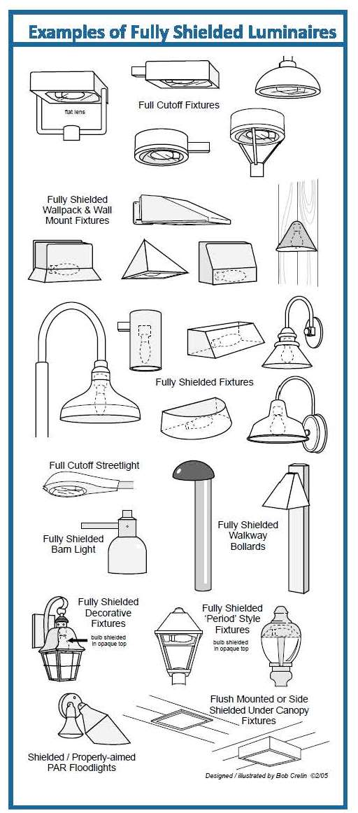
d.
Glare: Lighting entering the eye directly from luminaires or indirectly from reflective surfaces that causes visual discomfort or reduced visibility.
e.
Light Trespass: Light that falls beyond the property it is intended to illuminate.
g.
Lumen: The unit of measure used to quantify the amount of light produced by a lamp or emitted from a luminaire (as distinct from “watt”, a measure of power consumption).
h.
Luminaire: The complete lighting unit (fixture), consisting of a lamp, or lamps and ballast(s) (when applicable), together the parts designed to distribute the light (reflector, lens, diffuser), to position and protect the lamps, and to connect the lamps to the power supply.
i.
Luminaire Lumens: For luminaires with relative photometry per the Illuminating Engineering Society (IES), it is calculated as the sum of the initial lamp lumens for all lamps within an individual luminaire, multiplied by the luminaire efficiency. If the efficiency is not known for a residential luminaire, assume 70%. For Luminaires with absolute photometry per IES LM-79, it is the total luminaire lumens. The lumen rating of a luminaire assumes the lamp or luminaires is new and has not depreciated in light output.
j.
Lux: The International System of Unit (SI) of illuminance. One lux is one lumen per square meter. One lux is a unit of incident illuminance approximately equal to 1/10 footcandle.
k.
Partially Shielded: A luminaire with opaque top and translucent or perforated sides, designed to emit most light downward in such a manner that more than zero but less than ten per cent of the light emitted directly from the lamp or indirectly from the luminaire is projected at angles above the horizontal.
l.
Shielded Directional Luminaire: A luminaire that includes an adjustable mounting device allowing aiming in any direction and contains a shield, louver, or baffle to reduce direct view of the lamp.
m.
Spotlights: A lamp projecting a narrow, intense beam of light directly on to a place or person, especially a performer on stage. (As per the Oxford US English Dictionary.)
n.
Unshielded Luminaire: A luminaire capable of emitting light in any direction including downwards.
3.
Applicability: New Uses, Buildings and Major Additions or Modifications:
a.
New Development. For all proposed new land uses, developments, buildings, and structures that require a permit, Board of Zoning Appeals approval, and/or Plan Commission approval, all lighting fixtures shall meet the requirements of this section.
b.
Change in Use. If there is a change in use of the property, the provisions of this section shall apply when the new use commences.
c.
Additions or Modifications. All building additions or modifications of 25% or more in terms of additional dwelling units, gross floor area, or parking spaces, either with a single addition or with cumulative additions, shall cause the requirements of this section to apply to the entire property, including previously installed and any new outdoor lighting.
d.
Replacement Lighting. Cumulative modification or replacement of outdoor lighting constituting 25% or more of the permitted lumens for the parcel, no matter the actual amount of lighting already on a nonconforming site, shall constitute a major addition for purposes of this section.
e.
New Lighting. Any new outdoor lighting on the site shall meet the requirements of this section.
4.
Interpretation:
a.
Initial Lumens. For the purposes of the Zoning Code Ordinance, lumens” means “initial lumens.” The acceptability and shielding restrictions applicable to a particular lamp are decided by its initial lumen output, not wattage; check manufacturer’s specifications.
b.
Light Trespass Measurements. Measurements of light readings along any portion of a property line of the subject property shall be taken with a light meter facing the light source.
5.
Prohibitions:
a.
Laser Source Light. The use of laser source light or any similar high intensity light for outdoor advertising or entertainment, when projected above the horizontal or off site, is prohibited.
b.
Searchlights. The operation of searchlights is prohibited except when used by civil authorities for purposes of public safety.
c.
Strobe Light. The use of strobe or any similar light is prohibited.
d.
Towers. Tower lighting shall not be permitted unless required by the Federal Aviation Administration (FAA).
6.
Uniformity: All lighting fixtures and poles within a single development shall be consistent in style, color, size, height, and design and be compatible with the architecture of the building.
7.
Shielded: All freestanding lights and lights mounted on walls or facades shall have at least partially shielded luminaires.
8.
Design and Installation Guidelines:
All lighting fixtures shall be shielded with opaque material to prevent direct lighting on streets, alleys, and adjacent properties, except as specified otherwise herein.
All lighting fixtures shall be partially or fully shielded installed, except as specified otherwise herein.
a.
All lighting fixtures that are required to be shielded shall be installed and maintained in such a manner that the shielding is effective as described herein for shielded fixtures.
b.
A lighting fixture may beam light upward, if all such upward light is reflected back down by a canopy, roof, or other such fixture.
c.
All lamps emitting 1,000 lumens or more, except motion detector-activated lighting, must be either partially or fully shielded to an observer at the property line. This can be achieved with light fixture location, mounting height, natural or artificial barriers on the fixture owner’s property, fixture shielding, and other fixture design features.
d.
Floodlights and spotlights shall be fully shielded when the source is visible from any off-site residential property or public right-of-way.
e.
The centerline beam of a floodlight or spotlight shall be aimed no higher than 45
˚
above vertical; however, light fixtures that cast illumination over more than 90
˚
shall be aimed such that no light shall be cast above the horizontal.
9.
Architectural Accent Lighting: All ground lighting greater than 260 lumens used to cast light on building facades, building features, flags or signs shall have shields to ensure that light does not project beyond those features. The minimum amount of light necessary to light those features shall be utilized. The light fixture and bulb shall be shielded from view of any street, sidewalk, or parking lot.
10.
Light Trespass: All nonexempt lighting fixtures shall be installed so as to not cause light trespass beyond the property boundary.
a. When the adjacent property is either zoned or used for residential purposes, lighting from the subject property shall not cause more than one lux at any location along the adjoining property line.
b. When the subject property is zoned for commercial or industrial use and the adjacent property is also zoned and used for commercial or industrial use, lighting from the subject property shall not cause more than five luces at any location along the adjoining property line (only on the sides of the subject property that are adjacent to the similarly zoned district.)
11.
Outdoor Event Lighting: Outdoor Event/Sport field/Sporting Event lights shall not exceed one hundred (100) feet in height and shall be shut off by 11:00 p.m. on any given night in privately or publicly owned sport fields or as designated per park ordinance in sport fields regulated by the City of Auburn Parks Department or as permitted by the Board of Public Works and Safety.
12.
Maximum Luminaire Elevation: Parking lot lights shall not exceed twenty-five (25) feet in height, unless Plan Commission approval allows for an increased height subject to any defined conditions.
13.
Lighting Plan: The Lighting Plan shall be submitted in the form of a photometric plan, shall be reviewed as part of an Improvement Location Permit application, and shall also be required to be submitted with all Development Plans, where applicable.
14.
Exemptions:
a.
Carnivals and Festivals as Approved by the Board of Public Works and Safety. Lighting for temporary festivals and carnivals is exempt but should be in keeping with the intent of this section.
b.
Emergency Lighting. Emergency lighting, used by police, fire fighting, or medical personnel, or at their direction, is exempt from all requirements of this section.
c.
Holiday Lighting. Holiday lighting and seasonal decorations using typical unshielded low-intensity incandescent lamps are exempt from the provisions of this section.
d.
Low-intensity Lighting.
i.
No shielding is required for a light fixture with a bulb rated at 260 lumens or less.
ii.
Full shielding is not required for a light fixture with a bulb rated at more than 260 lumens and less than 1,000 lumens when the bulbs are installed inside frosted glass or other translucent covers and shielded on top.
iii.
The total lumens of bulbs specified in Section 150.310 J.) 14.) e.) i.) Low-intensity Lighting and Section 150.310 J) 14) e) ii.) Low-intensity Lighting, when not motion detector activated, shall not exceed 2,000 lumens per building, or 1,000 lumens per exterior entryway, whichever is less.
e.
Swimming Pool and Fountain Lighting. Underwater lighting used for the illumination of swimming pools and fountains is exempt from the lamp type and shielding standards provided herein, though it must conform to all other provisions of this section.
f.
Traffic Control Lighting. Traffic control lighting is exempt from the provisions of this section.
150.311 SUPPLEMENTARY USE REGULATIONS
A) 1) TEMPORARY BUILDINGS
No temporary building or temporary structure shall be erected, reconstructed, enlarged, or moved on to any lot, plot or tract of land unless it conforms with this chapter.
2) A manufactured structure may be moved on to a lot, plot or tract of land and may be used as a temporary office, and provided that the following conditions are met:
a) The Administrator/Zoning Administrator shall issue a building permit for such temporary use for a period not to exceed six months. Upon expiration, the building permit may be extended for up to one additional year by the Administrator/Zoning Administrator upon adequate showing by the owner that the permanent building on the lot is not suitable for occupancy due to conditions beyond his control. Only one said extension shall be allowed for said permit, after the final expiration of said permit, the temporary office shall be vacated and removed within 30 days of the expiration date.
b) The temporary field office shall comply with all county and state health requirements which would be imposed upon a permanent residence on the same lot, plot or tract.
c) A construction field office is exempt from division (a) above.
3) A recreational vehicle is permitted as a temporary accessory use without regard to the other provisions of this chapter except as specified in this division (3), and provided that the following conditions are met:
a) Such recreational vehicle shall be permitted only on the property for a maximum of 60 days. Thereafter, the recreational vehicle shall be removed from the property for a period not less than 30 days;
b) Such recreational vehicle shall be permitted only on property having an existing permanent dwelling;
c) Such recreational vehicle shall be occupied by a member of the family (father, mother, son or daughter, and the like) residing in the permanent dwelling, or by an employee of the resident in the permanent dwelling;
d) Such recreational vehicle shall not be permitted to encroach on the required yard or setback as specified by the zone in which it is located.
B) ACCESSORY BUILDINGS
An authorized accessory building may be built as part of the principal building, or it may be connected to it by a roofed-over porch, patio, breezeway or similar structure, or they may be completely detached. If the accessory building is detached from the principal building, it must be at least ten feet from any other separate structure on the same lot.
C) JUNKED MOTOR VEHICLES
Junkyards and vehicle storage yards are permitted in I-2 and I-1 Districts (see 150.235 and 150.236). These regulations are not intended to limit or restrict the hobbyist or sports car enthusiast. However, if a hobby use is claimed, the vehicles to be restored shall be specifically identified to the Zoning Administrator and all restoration processes shall be kept wholly within a building. Vehicles or parts of these for hobby use may be kept outside of a building, provided the vehicle or parts of them are not in view from a public thoroughfare or are screened from view by a Commission-approved material.
D) EXCAVATION OF TOPSOIL
Topsoil shall not be stripped, excavated or otherwise removed on any premises for sale or for use except for the following conditions:
1) When in connection with a building permit authorized excavation of other soils as provided in division (E) below.
2) When as a product of a building permit authorized excavation of other soils as provided in division (E) below.
E) EXCAVATION OF SOILS AND MATERIALS
The excavation of all types of soils and minerals other than topsoil may be authorized in any district except a Wetland (W) District by the City Board of Zoning Appeals by the issuance of a special use permit. To obtain a special use permit, procedures must be completed which establish specified conditions and safeguards. A special use permit may include authorization for the erection, installation and use of necessary buildings, equipment and additional accessories necessary for the excavation operation. A special use permit may also describe the condition in which the property is to be left after the excavation is completed.
150.312 HEIGHT REGULATIONS
A) Except as otherwise specifically provided in this chapter, no building or structure shall be erected, altered, enlarged or reconstructed to exceed the height limit established for the district where such building or structure is located as follows:
��District
|
Maximum Height in Feet
|
A-1
|
40
|
R-E
|
35
|
R-1
|
35
|
R-2
|
35
|
R-3
|
40
|
C-1
|
35
|
C-2
|
40
|
I-1
|
70
|
I-2
|
80
|
MH
|
35
|
OS
|
35
|
1) All areas governed by the Federal Aviation Administration (FAA) due to the area's proximity to an airport or airstrip shall be governed by the appropriate FAA height regulations.
2) All height regulations and exceptions excluding telecommunication facilities and cell towers (see section B) 6) shall not exceed the current firefighting limits of the City Fire Department.
B) EXCEPTIONS TO HEIGHT LIMITATIONS
1) In an R-3 District, any permitted dwelling may be increased in height provided each required side yard is increased an additional one foot for each additional height of three feet exceeding 40 feet.
2) In I-1 and I-2 Districts, any permitted building may be increased in height provided each required side yard is increased an additional one foot for each additional height of one foot exceeding 70 feet for I-1 and 80 feet for I-2.
3) On through lots 150 feet or less in depth, the height of a building may be measured from the adjoining curb level on either street.
4) On through lots more than 150 feet in depth, the height regulations and basis of height measurements shall be from the curb permitting the greater height.
5) Penthouses or roof structure for the housing of elevators, stairways, tanks, ventilating fans or similar equipment required to operate and maintain the building, fire or parapet walls, skylights, television aerials, electrical transmission poles and substations, and communication facilities and poles, excluding wireless telecommunication facilities and cell towers (see 6 below), theater screens, steeples, roof signs, flagpoles, chimneys, smokestacks, wireless masts, water tanks, gas containers, industrial installation requiring a vertical production procedure such as flour mills, steel mills and refineries, or similar structures may be erected above the height limits herein prescribed, but no such structures, or any place above the height limit, shall be allowed for the purpose of providing additional floor space for residential, business or industrial use.
6) Telecommunications Facilities and Cell Towers
General Purpose is:
a)
To regulate the location of wireless telecommunication facilities and cell towers within the City’s planning jurisdiction.
b)
To protect certain land uses and residential areas from potential adverse impacts of telecommunication facilities and cell towers.
c)
To promote and encourage shared use and co-location of wireless telecommunication facilities and cell towers as the primary option before the construction of new facilities.
d)
To provide visual impact guidelines through landscape and design standards in support of the location of these facilities with the surrounding land uses and zoning districts.
e)
To insure that such facilities and structures are designed, constructed, and maintained in a safe and sound manner.
Telecommunications facilities and cell towers are subject to the following requirements:
a)
Wireless telecommunications facilities and cell towers shall require;
i)
Contingent Use approval by the Board of Zoning Appeals,
ii)
Site Plan review by the Administrator/Zoning Administrator and,
iii)
Shall meet all other requirements of this chapter. Applicants are encouraged to setup a pre-application meeting with Planning Department staff.
b)
Demonstrate that the telecommunications tower is reasonably necessary to serve the adjacent or nearby area.
c)
No new telecommunications tower shall be permitted unless the applicant is unable to locate or co-locate on an existing structure.
Documentation Criteria from the Tower Applicant(s):
a)
Provide a statement explaining the purpose of the tower, why it is needed and the reason(s) for the proposed location (include a list of any nearby existing towers)
b)
Document efforts towards co-location; the applicant is to provide a statement addressing efforts made to co-locate on existing towers (please include a list of towers where co-locations were attempted and reasons why co-locations were unsuccessful). Note: Co-location shall mean the use of an existing tower or structure to support antennae for wireless services without increasing the height of the tower or structure.
c)
Provide evidence to the Board of Zoning Appeals for its review that no existing towers are suitable. This evidence may consist of the following:
i)
Height of existing tower(s) not sufficient,
ii)
Existing tower(s) structural strength won’t support the equipment,
iii)
The location of the sight would cause interference with the applicant’s antennae,
iv)
Unwillingness of existing tower owners to allow co-location,
v)
Cost to construct co-location is not reasonable or would exceed new tower development or,
vi)
Any other limiting factors that render the existing towers unsuitable.
d)
The telecommunication facilities and cell towers shall not exceed 200 feet in height (including antennas) and any accessory structure(s) shall not exceed 15 feet in height. All new telecommunication facilities and cell towers shall be designed so as to accommodate at least three telecommunication antennas.
e)
All wireless telecommunication facilities and cell towers shall be a monopole design.
i)
Guyed and self-supporting lattice towers shall not be permitted.
f)
The setback requirement for towers shall be as follows. Setbacks shall be measured from the base of the tower to the applicable property lines or street right-of-way:
��SETBACK REQUIREMENTS FOR CELL TOWERS
|
��i.
Front yard from road right-of-way (including through lots and corner lots)
|
75% of tower structure height
|
Side and rear yards from adjacent property line – interior lot line
|
75% of tower structure height or 60 feet, whichever is greater
|
Design Standards – General
i)
Telecommunication Towers and the tower site area are to be designed to blend into the surrounding environment through use of color, camouflaging and architectural treatment. The tower site area is defined as the area surrounding the telecommunication tower, antennae, all communication equipment, and screening.
ii)
Only lighting used for safety reasons and/or required by the FAA not to be in conflict with the city’s lighting ordinance.
iii)
Fencing shall be required to enclose the tower site area. The fencing shall be at least 6ft. in height and not to exceed 8 ft. in height. The fencing in industrial districts can be chain link, or solid surface made of wood or masonry, or other materials. The fencing in residential districts shall be solid surface made of wood or masonry, or other materials. However, the use of barbed wire or sharp pointed or razor fencing shall be prohibited in all districts.
iv)
Screening and landscaping around the enclosed area of the tower site area shall include evergreen trees or evergreen shrubs with a minimum height of 5 feet planted in a scattered pattern at a maximum distance of 10 feet on center. The screening can be placed along the perimeter of the fencing or between the property line and the fenced area at a minimum 10ft. buffer, allowing for the required setbacks by zoning district. Any existing natural vegetation that provides sufficient screening may substitute for the screening requirements. A five year bond shall be provided to the city to insure the plant viability of the required landscape screening. The bond is to be equal to fifty (50%) of the initial cost of the installation of the landscape screening.
v)
There shall be no signs permitted except for emergency and owner contact information and warning and safety instructions. Signs are not to exceed 5 sq. ft. in area.
vi)
All new cellular antenna towers shall be designed and constructed to accommodate at least 3 service providers.
g)
Design Standards – Construction
i)
Provide a vertical profile sketch and structural renderings of the tower prepared and signed by a professional engineer indicating the tower height, location (site plan), the placement of all the antennas and the locations of all co-location sites.
ii)
A professional engineer’s certification shall be submitted for all telecommunication towers and communication equipment to document and verify design specifications including but not limited to; foundation of tower, strength of the tower to withstand wind gusts of up to 90 miles per hour with a half inch of ice, and other natural forces such as ice loading and earth movements.
iii)
All telecommunication towers and communication equipment must meet or exceed current standards and regulations of the FAA, FCC and other regulatory authorities for telecommunication towers.
iv)
All telecommunication towers and communication equipment shall be certified by a professional engineer to conform to City of Auburn building code, International Building Code, National Electrical Code, OSHA, and ANSI.
h)
Removal of Cell Towers:
i)
The City will require that any contract with an owner of property on which a cell tower or antenna is to be constructed shall include a provision that specifies in the case of abandonment the method that will be used to dismember and remove the cell tower and/or antenna, concrete, fencing and all other project related improvements to a depth of 48 inches beneath the soil surface. The area occupied by the project improvements shall be restored as near as practicable to the same condition that existed immediately before construction of such improvements.
ii)
To ensure the removal of all improvements of any cell tower the applicant must provide to the Department of Building, Planning and Development either a performance bond, a letter of credit, or some other form of security acceptance to be equal to 100% of the cost of the removal of the tower, tower foundation and tower site area including an inflation factor based on the estimated life expectancy of the tower.
iii)
If the use of any cellular antenna or cellular antenna tower or alternative cellular antenna tower structure is discontinued, the owner shall provide the Department of Building, Planning and Development with a copy of the notice to the FCC of intent to cease operations within 30 days of such notice to the FCC.
iv)
If the cellular antenna or cellular antenna tower or alternative cellular antenna tower structure will not be reused, the owner shall have 180 days from submittal of the FCC notice to the Department of Building, Planning and Development to obtain a demolition permit and remove the antenna or tower that will not be reused.
v)
If the cellular antenna or cellular antenna tower or alternative cellular antenna tower structure is to be reused, the owner shall have no more than twelve (12) months from the submittal of the FCC notice to the Department of Building, Planning and Development in which to commence new operation of the antenna or tower to be reused.
vi)
Upon failure to commence new operation of the antenna or tower that is to be reused within twelve (12) months, the cellular antenna or cellular antenna tower or alternative cellular antenna tower structure shall be presumed abandoned, and the owner shall immediately obtain a demolition permit and remove the antenna or tower that is presumed abandoned.
vii)
If the owner fails to remove an antenna or tower in the time provided by this section, the Department of Building, Planning and Development may cause the demolition and removal of the antenna or tower and recover its costs of demolition and removal from the security acceptance provided by the applicant pursuant to this section.
150.321 EXCEPTIONS TO AREA AND WIDTH REQUIREMENTS
A) RECORDED LOTS
Any residential lot created and recorded prior to the effective date of this chapter may be used for residential purposes even though the lot area or dimensions are less than those required for the district in which such a lot is located, provided:
1) That no adjacent land or lot is owned by the owner of the lot in question at the effective date of this section; and
2) That the other requirements of the district are met to the extent possible as determined by the Administrator/Zoning Administrator.
3) "BLOCKS" of substandard sized lots that are contiguous to each other and under the ownership of one owner shall be combined in a manner where the new lots shall conform to the area and width requirements of this chapter unless waived by the Board.
B) Upon proper application, the Board of Zoning Appeals may vary the yard requirements for substandard lots recorded prior to the effective date of this section. No more than a minimum variance from the terms of this chapter shall be granted which is necessary to relieve the practical difficulty of building on any substandard lot of record.
C) No portion of a lot can be used more than once in complying with the provisions for lot area and yard dimensions for the construction of a proposed, or the alteration of an existing building.
150.330 YARD REQUIREMENTS - ALL DISTRICTS CONFORMING TO YARD
REGULATIONS
Except as hereinafter provided, no building or structure shall be erected unless such building or structure conforms; and no building or structure shall be altered, enlarged or reconstructed unless such alteration, enlargement or reconstruction conforms with the yard regulations of the district in which it is located, as follows:
A) Front yard requirements
Each lot shall have a front yard with a minimum depth measured from, and parallel to, the center line of any street or highway. The minimum front yard depths shall be as follows:
��District
|
Major or
Arterial
Streets
|
Collector
Or Feeder
Streets
|
Local or
Residential
Streets
|
A-1
|
70
|
63
|
70
|
RE
|
70
|
63
|
70
|
R-1
|
70
|
63
|
70
|
R-2
|
70
|
63
|
60
|
R-3
|
70
|
63
|
60
|
C-1
|
100
|
100
|
100
|
C-2
|
100
|
100
|
100
|
I-1
|
100
|
100
|
100
|
I-2
|
100
|
100
|
100
|
��MH
|
As established by the Commission
|
1)
Front yards on a through lot
At each end of a through lot, there shall be a front yard which conforms to the district requirements in which each street frontage is located. One such front yard may serve as a required rear yard to permit accessory structures.
2) Front yard between buildings
Where a lot is situated between two lots, each of which has an existing main building thereon, the front yards of which are less than the minimum required front yards established herein, the front yard requirement of such lot shall be the average of the front yards of said existing buildings.
3) Corner lot, side yard width to the side street line
In the case of a corner lot, the side yard width to the side street line shall be equal to the front yard depth requirement for the district in which the lot is located. In case of a corner lot in an R-2 District, the side yard width on the street side shall be not less than six feet from the setback specified in this section.
4) Front yard, adjoining building
Where a lot abuts only one lot having an existing main building thereon, the front yard of which is less than the minimum required front yard established herein, the front yard requirement of such lot shall be the average of the front yard of the existing building and the required front yard.
B) Side yard requirements
There shall be two side yards for each lot. The minimum width for each yard shall be as follows:
��District
|
Minimum Width of
One Side Yard in Feet
|
A-1
|
10
|
RE
|
10
|
R-1
|
10
|
R-2
|
8
|
R-3
|
10
|
C-1
|
10
|
C-2
|
10
|
I-1
|
10% of building line, not to exceed 40
|
I-2
|
10% of building line, not to exceed 40
|
MH
|
See 150.251
|
OS
|
8
|
1) When an R-3 District abuts an RE, R-1 or R-2 District, the side yard shall be 25 feet on the abutting side only.
2) When either a C-1 or C-2 District abuts an RE, R-1, R-2, R-3 or MH District, the side yard shall be 25 feet on the abutting side only.
3) When an I-1 District abuts an RE, R-1, R-2, R-3 or MH District, the side yard shall be 50 feet on the abutting side only.
4) When an I-2 District abuts an RE, R-1, R-2, R-3 or MH District, the side yard shall be 200 feet on the abutting side only.
5) Side yards waived
For the purpose of side yard regulations, dwellings with common party walls shall be considered as one building occupying one lot.
C) Rear yard requirements
There shall be a rear yard for each lot, the minimum depth for which shall be as follows:
��District
|
Depth (In Feet)
|
A-1
|
30
|
RE
|
30
|
R-1
|
30
|
R-2
|
30
|
R-3
|
20
|
C-1
|
30
|
C-2
|
30
|
I-1
|
Same as side yard
|
I-2
|
Same as side yard
|
MH
|
See 150.251
|
OS
|
30
|
1) When a RE, R-1 or R-2 District lot's depth is greater than 150 feet, the rear yard shall be no less than 40 feet.
2) When an R-3 District abuts a RE, R-1 or R-2 District, the rear yard shall be 25 feet.
3) No accessory building shall be closer than five feet to the rear lot line.
150.331 GENERAL PROVISIONS AND EXCEPTIONS TO YARD REQUIREMENTS
A) YARDS APPLY ONLY TO ONE BUILDING
No required yard, or other open space, around an existing building, or which is hereafter provided around any building for the purposes of complying with the provisions of this chapter, shall be considered as providing a yard or open space for any other building; nor shall any yard or other required open space, on any lot, be considered as providing a yard or open space for another lot on which a building is to be erected.
B) PROJECTIONS INTO YARDS
1) Cornice, sill, chimney or fireplace
A cornice, eave belt course, sill, canopy or other similar architectural feature (not including bay window or other vertical projection which shall be a part of the main building) may extend or project into a required side yard not more than two inches for each one foot of width of such side yard and may extend or project into a required front or rear yard not more than 30 inches. Chimneys or fireplaces may project into a required front, side or rear yard not more than two feet, provided the width of such side yard is not reduced to less than three feet.
2) Fire escape
A fire escape may extend or project into any front, side or rear yard not more than four feet.
3) Open stairway or balcony
An open, unenclosed stairway or balcony, not covered by a roof or canopy, may extend or project into a required rear yard not more than four feet, and such balcony may extend into a required front yard not more than 30 inches.
4) Open porch
Unenclosed porches, roofed and unroofed, may project into a required side or rear yard a distance not to exceed eight feet provided:
a) Where a porch is unenclosed, no higher than one story.
b) The porch shall not be closer than eight feet at any point to any side or rear lot line.
c) No building shall have more than one porch in any one yard.
5) Enclosed porch
Enclosed porches, either one-story or two-story, shall be considered an integral part of the building and shall, therefore, be subject to all yard and area dimensional requirements established for principal buildings.
C) FENCES, WALLS, HEDGES OR OTHER SPECIFIED PLANTINGS OR STRUCTURES
1) Fences or walls
May be located in the required front, side or rear yard subject to the following conditions:
a) Fences or walls shall not be constructed inside of the right-of-way of any street, road or highway.
b) Fences or walls shall not be constructed within or inside of the City of Auburn public utility and/or drainage easements without the City of Auburn Board of Public Works and Safety approval.
c) Electrical, barbed wire or charged fences shall not be permitted in any yard within the city, with the exception that barbed wire shall be allowed within areas zoned as Agricultural (A-1) and Industrial (I-1 or I-2 Districts).
d) No fence, wall or structural screen, other than plant materials, shall be erected on a residential property higher than six feet.
e) No fences, walls or hedges shall be constructed, placed, planted or maintained in the front yard in any district except industrial districts unless:
1) The hedges are no more than three feet in height and are ornamental in character.
2) The fences which do not create a visual or physical barrier (i.e., split-rail fences) and whose purpose cannot serve a physical function other than for decoration or aesthetic appeal and are no more than three feet in height are permitted.
3) The fences or hedges are free from points, barbs or thorns which could cause puncture wounds to persons falling upon them. Particularly, no woven wire, barbed wire or other wire fences shall be erected in the front yard of any of the districts.
2) Trees, shrubs, flowers or plants
Shall be permitted in any required front, side or rear yard provided they do not violate the provisions for corner setbacks required in this section.
3) Other specified structures
Walks, driveways, curbs, retaining walls, mailboxes, name plates, lamp posts, birdbaths and similar structures shall be permitted in any required front, side or rear yard.
4) Design-construction requirements
A minimum of 10% of a parking area with a capacity of ten or more vehicles located in a C-2 District shall be landscaped. A buffer required by 150.350(H)(7) or (H)(8) may be counted toward meeting this requirement.
D) CORNER VISIBILITY
No fence, wall, hedge, planting or other obstruction to vision, extending in excess of three feet, but less than ten feet, above the established street center line grade shall be erected or maintained on that part of a corner lot that is included between the lines of intersecting streets and a line intersecting them at points 30 feet distant from the intersection of the street lines.
E) EXCEPTIONS TO YARD REQUIREMENTS
1) Corner lot
On a corner lot, the required rear yard, as defined by this chapter, may be reduced to no less than 20 feet subject to the following conditions:
a) The front yard complies with the minimum setback requirements established in this chapter, or with platted building lines.
b) The side yard, as defined by this chapter, adjacent to a street shall also meet the minimum front yard requirements of this chapter, or the platted building lines, whichever are more restrictive.
c) The internal side yard, as defined by this chapter, shall not be less than 25 feet. No encroachment of this minimum requirement will be allowed except by the granting of a variance of the Board of Zoning Appeals.
2) Internal lot
For internal lots that do not have parallel sides or parallel front and rear lines, the required side and rear yards may be established by using an average distance between the building and non-parallel side or rear line. In no event shall any part of the lot be nearer than eight feet from a side line and 20 feet from a rear line unless authorized by the Board of Zoning Appeals.
150.340 RESIDENTIAL BUILDING SIZE - SPECIFIED DISTRICTS
No building or structure shall be erected, enlarged or reconstructed for residential purposes having a ground floor area, exclusive of unenclosed porches, terraces, breezeways and garages, or less than the minimum established for the district wherein such building or structure is located, as follows:
��Ground Floor Area of Building (Square Feet)
|
��| District
|
One Story
|
More Than One Story
|
| A-1, RE, R-1, R-2, R-3
|
950
|
700
|
| One dwelling unit
|
950
|
700
|
| Two dwelling units or more
|
500/unit
|
500/unit
|
| MH (Manufactured House)
|
950
|
700
|
150.350 OFF-STREET PARKING
A) MINIMUM REQUIREMENTS
1) The following off-street parking spaces shall be provided and maintained by the owner of, or persons using, property for each building which is hereafter erected, or the use of which is hereafter changed, and for which such new use requires a greater number of parking spaces. As used in this section, the term "GROSS FLOOR AREA" as applied to office, merchandising or service types of uses, shall mean the gross floor area used or intended to be used for services to the public as customers, patrons, clients, patients, or tenants, including areas occupied for fixtures and equipment used for display or sale of merchandise, but excluding floor areas which are used exclusively for storage, for housing of mechanical equipment integral within the building, for maintenance facilities, or for those areas so restricted that customers, patients, clients, salesmen and the general public are denied access.
2) The requirements for an off-street parking facility for a use not specifically mentioned shall be those requirements for a use which is mentioned and which is most similar to the use not mentioned.
3) The number of parking spaces required for any particular building or land use shall be calculated on the basis of specific need. A calculation of the number of spaces needed resulting in a fraction of a space shall be corrected by deleting any space less than one-half of a full space.
4) Each automobile parking space, as required, shall be not less than 180 square feet in area.
5) Off-street parking spaces shall be provided as shown in the following schedule plus one space for each two employees for all uses of this schedule. Understanding that the following schedule may not always address every situation or use and that parking standards will change over time, the Administrator/Zoning Administrator shall have the discretion to adjust these off-street parking requirements based on the current edition of the “Parking Generation” report as prepared by the Institute of Transportation Engineers.
��Single-family or two-family dwelling
|
At least two parking space per dwelling
|
Multi-family (three or more) dwelling
|
At least two parking spaces per family
|
Hotel, motel, auto-courts, tourist homes or any similar use
|
At least one parking space per sleeping room in addition to whatever spaces may be required for restaurant facilities
|
Hospitals, sanitariums, nursing homes, homes for the aged, or any similar use
|
At least one parking space each bed plus one space for each doctor
|
Medical clinic or any similar use
|
At least four parking spaces per doctor/dentist and one per each employee
|
Libraries, museums, and post offices
|
At least one parking space for every 400 square feet of floor space
|
Schools, public and parochial
|
At least one parking space for each employee plus one parking space for each 20 students
|
Auditoriums, churches, funeral homes, mortuaries, theaters, gymnasiums, stadium or any other place of assembly with or without seats
|
At least one parking space for each four seats based on the maximum seating capacity including fixed and movable seats
|
Office building, bank, professional office or any other similar use
|
At least one parking space for each 200 square feet of gross floor area
|
Food market establishments or any similar use
|
At least one parking space for each 200 feet of gross floor area
|
Eating or drinking establishments or any similar use where customers are seated and served within a building
|
At least one parking space for each three seats
|
Eating or drinking establishments or any similar use where customers are served outside of a building
|
At least one parking space for each 50 square feet of gross floor area, provided that there shall not be less than six parking spaces for each such establishment
|
Furniture, hardware, household appliance, automobile sales, machinery sales or mechanical trades display store or any similar use
|
At least one parking space for each 1,000 feet of gross ground floor area plus one parking space for each 1,500 square feet of gross floor area other than the ground floor used for sales display or show purposes
|
Automobile service and repair, garages, and gasoline filling and service stations
|
At least two parking spaces for each repair and service stall
|
Automatic car wash
|
A reservoir of space adequate to serve at least five automobiles per washing lane
|
Self-service car wash
|
At least three parking spaces for each washing stall
|
Bowling alley
|
At least three parking spaces for each bowling lane plus additional space for affiliated uses such as bars or restaurants
|
Barber shops and beauty shops
|
At least three parking spaces for each barber or beautician using the shop
|
Launderette, laundromat, self-service laundry, washateria or similar use
|
At least one parking space for each two washing machines or portions any thereof
|
All other retail stores and service establishments
|
At least one parking space for each 400 square feet of floor space
|
Commercial or business office having a gross floor area in excess of 10,000 square feet an occupied solely by the employees of one owner
|
At least one parking space for each 800 square feet of floor area
|
Industrial, processing or manufacturing establishment, warehousing, storage, or any other similar industrial use or commercial establishment not specifically set out in this section
|
At least one parking space for every two employees for industries using two or more shifts; at least one parking space for every three employees for industries using one shift only; plus sufficient spaces to park all company owned or leased vehicles
|
Mobile/manufactured projects
|
At least two parking spaces for lot
|
B) JOINT USE OF PARKING AREAS The joint use of parking facilities by two or more uses is recommended whenever the use is practicable and satisfactory to each of the uses intended to be served and when all requirements for location, design, and construction can be satisfied. In computing capacities of any joint use, the total space requirement is the sum of the individual requirements that will occur at the same time. If peak space requirements for individual uses occur at distinctly different times from the peak requirements for other joint uses, the maximum capacity required for joint use will be less than the sum of total individual space requirements. A copy of an agreement between joint users shall be filed with the Clerk-Treasurer. The agreement shall include a guaranty for continued use of the parking facility for each party to the joint use.
C) COLLECTIVE PARKING FACILITIES
Nothing in this section shall be construed to prevent collective provision for any off-street parking facilities for two or more buildings or uses. However, the total number of off-street parking spaces shall not be less than the sum of the requirements for the various individual uses involved, computed separately, on the basis of the items set out in this section.
D) ACCESS
All parking facilities provided pursuant to this section shall be accessible to and from a street.
E) DISTANCE MEASUREMENTS
The distance to any parking space area, as herein required shall be measured between the nearest point of the off-street parking facility and the nearest point of the building said parking facility is to serve.
F) LOCATION OF PARKING AREAS
1) For one- and two-family dwellings: on the same lot with the building they are required to serve.
2) For multiple-family dwellings not over two stories in height: on the same lot or parcel of land as the building they are required to serve. For the purpose of this requirement, a group of those uses constructed and maintained under single ownership or management shall be assumed to be on a single lot or parcel of land.
3) For apartment houses containing four or more dwelling units on the same lot or parcel of land as the building they are required to service, or on a separate lot or parcel of land not more than 300 feet from the nearest entrance to the principal building being served, if the lot or parcel of land selected for the parking facilities is located in an apartment district or a less restricted district.
4) For uses other than those specified above, off-street parking facilities shall be provided on the same lot or parcel of land as the principal building being served, or on a separate lot or parcel of land not over 300 feet from the entrance of the principal building, measured from the nearest point of the parking area, if the separate lot or parcel of land intended for the parking facilities is located in the same district as the principal permitted use or in a less restricted district.
G) REVIEW OF PLANS
All access drives and parking areas shall be approved by the Plan Commission except for A-1, RE, R-1 and R-2 developments. The plans and specifications shall show the location, basis of capacity calculation, size, site design, surfacing, marking, lighting, drainage, curb cuts, entrances, exits, and any other detailed features essential to the complete design and construction of the parking area and be reviewed by the City Engineer and City Utility Departments. All properties subject to this subsection shall be limited to one access drive.
H) DESIGN-CONSTRUCTION REQUIREMENTS
In addition to general design, the requirements specified in other paragraphs of this section and the following design and construction requirements shall be satisfied in all off-street parking areas with any exceptions noted.
1) Except for single-family dwellings, a minimum area of 180 square feet shall be provided for each vehicle parking space. Each space shall be definitely designated and reserved for parking purposes, and all spaces shall be accessible from a street.
2) Parking areas shall be so designed and marked as to provide for orderly and safe movement and storage of vehicles.
3) Except for parking space provided on residential lots, an access drive shall be provided not less than 20 feet wide and so located as to secure the most appropriate development of the individual property.
4) Except for parking space provided on residential lots, no parking area shall be constructed less than 1,000 square feet in area.
5) Parking areas with a capacity of four or more vehicles shall be surfaced with a material that shall provide a hard and dustless surface, i.e., concrete or asphalt, and shall be graded and provided with adequate drainage facilities to dispose of all collected surface water. Stone or gravel parking lots shall not be permitted. All parking areas shall be adequately maintained so as to continue to provide a durable, smooth and dustless surface.
6) Except for single-family and two-family residential lots, adequate lighting shall be provided for use when a parking area is in operation. All lighting shall be arranged so that no source of light shall be visible beyond the parcel lot upon which the parking area is located.
7) A parking area with a capacity of ten or more vehicles shall have a buffer at least five feet wide between the parking area and any adjoining property, and a vertical screen shall be erected consisting of structural or plant materials no less than four feet in height.
8) Where a parking area with a capacity of four or more vehicles adjoins a public street, a buffer at least five feet wide shall be provided between the parking area and the adjoining right-of-way.
I) USE OF PARKING AREAS
No commercial repair work, service, or selling of any kind shall be conducted on any parking area except that which is a part of a drive-in business. Only signs essential to the function of the parking area shall be displayed.
J) INCREASES IN PARKING AREAS
Any increase in effective capacity of any premise use for which off-street parking is required in accordance with this chapter shall be accompanied by the provision and maintenance of parking space in proper ratio to the increased capacity.
150.351 OFF-STREET LOADING AND UNLOADING
A) Every building, structure, or part thereof, hereafter erected, established, enlarged or occupied for the purpose of manufacturing, storage, warehousing, goods display, retailing, wholesaling and marketing; or for erecting, establishing, enlarging or occupying a hotel, a laundry, a dry cleaning shop, or other uses involving the receipt or distribution by vehicles of material or merchandise, shall provide and maintain space on the same premises, for vehicles to stand, load and unload, as follows:
1) A 12-foot by 35-foot loading space, with a 14-foot height clearance, for every 20,000 square feet, or fraction thereof, in excess of 3,000 square feet of floor area or land used for the above mentioned purposes.
2) In no case shall the required off-street loading space be part of the area used to satisfy the off-street parking requirements of this chapter.
B) In the event the loading area is within 400 feet of an R District and the loading area is not obstructed from view from the R District by a physical barrier, the area shall be screened in accordance with 150.350 (H)(7) and (8) of this chapter and amendments hereto.
C) Access to a truck standing, loading, and unloading space shall be provided directly from a public street or alley, or from any right-of-way that will not interfere with public convenience and that will permit orderly and safe movement of truck vehicles.
150.360 CONTINGENT USES - ALL DISTRICTS
A) Intent
The contingent uses hereinafter set forth shall be permitted by the Board of Zoning Appeals after public hearing, in any district where such uses are essential or desirable to the public convenience or welfare. No permit for a contingent use shall be granted if the Board shall find that such use is in conflict with any plan duly adopted by the city or the provisions of any section of the Auburn Zoning Ordinance governing overlay districts. In granting such permit, the Board may impose appropriate conditions regarding the location, character and other features of the proposed building, structure or use as are reasonably required by the purposes of this Title XV.
B) Such permitted contingent uses are identified as follows:
1) Cemetery
2) Governmental installation not otherwise permitted
3) Hospital, nursing home, mental health institution, health maintenance organization, or asylum not otherwise specified in this chapter
4) Public utility facilities such as:
a) Television transmitting stations, cell towers, antennas, and other related transmitting and/or telecommunication facilities;
b) Petroleum and natural gas transmission lines;
c) Pumping stations and facilities;
d) Railroad lines;
e) Electric substations and telephone exchanges where not otherwise permitted by this chapter;
f) Other similar uses of a public utility or public service nature, including structures and appurtenances for their enclosure, maintenance and operation.
5) Educational institution
6) Private school
7) Golf courses/country clubs
8) A not-for-profit neighborhood community building or education, recreational, or cultural establishment provided that the dispensing of alcoholic beverages or any business activity on said premises shall not be permitted and that no permit shall be issued for such use unless the Board shall first find that said use is of a nature compatible with the character of the neighborhood in which it is to be located.
9) Fire stations
10) Police stations
11) Municipal or county-owned parking lot
12) Transient amusement enterprise or circus, the chief activity of which is carried on for gain or profit
13) Other such similar uses as may be determined by the Plan Commission.
14) Churches
150.361 CONTINGENT USES - SELECTED DISTRICTS
A) Intent
Contingent uses in the following selected districts may be permitted by the Board of Zoning Appeals, only after public hearing in the specified districts indicated below. No permit for a contingent use shall be granted unless the Board shall have first found that the public convenience and welfare will be substantially served and that the proposed use will not be unduly detrimental to the surrounding area. The Board may, in exercising its approval, impose conditions regarding the location, character and other features of the proposed building, structure or use as it may deem advisable in furthering the purposes of this chapter.
B) Selected districts
In A-1 (Agricultural/Low Density Residential District), C-2 (General Commercial), I-1 (Light Industrial/High-Tech/Heavy Commercial), and I-2 (Heavy Industrial) Districts, the Board of Zoning Appeals may permit the following:
1) Fairground
2) Gun club, or indoor target range, provided that satisfactory evidence is presented to the Board of Zoning Appeals that adequate precautions will be taken to safeguard the public from the dangers of firearms used therein.
3) Animal breeding and raising for experimental laboratory or for production purposes, and animal kennels, as distinguished from general livestock raising.
4) Golf driving range, putting green or miniature golf course
5) Recreational vehicle park
150.362 FACTORS FOR PERMITTED CONTINGENT USES
A) In considering a petition for any permitted contingent use, the Board of Zoning Appeals shall give due regard to the following factors as they apply to a particular situation:
1) The nature, location, size and site layout of the use so that it shall be harmonious to the district in which it is situated.
2) The nature and integrity of the operations involved in, or connected with, the use.
3) The site layout of the use, including parking space requirements.
4) The relation of the use to the streets providing access to it, so that vehicular traffic to and from the use will not create undue hazards to the normal traffic of the vicinity. The following traffic issues, among others, will be considered:
a) Vehicular turning movement in relation to routes of traffic flow;
b) Relation to street intersections;
c) Sight distances;
d) Pedestrian traffic
B) All contingent uses which existed upon the effective date of this chapter and which are located in a district which permits such use in accordance with the provisions of this section, shall be regarded as expansion or extension to such uses shall be subject to Board review and approval as required for all contingent uses.
C) All contingent uses hereafter authorized by the Board to be in accordance with the provisions of this section shall be regarded as conforming uses and may be continued, except that major changes in layout, expansion or extension to such use shall be subject to Board review and approval as required for all contingent uses.
150.370 PURPOSE OF SPECIAL USES
Until recent years, the regulations of all uses of land and structures through zoning has been accomplished by assigning each use to one or more use districts. However, the functions and characteristics of an increasing number of new kinds of land uses combined with conclusive experience regarding some of the older familiar kinds of uses call for a more flexible and equitable procedure for property accommodating these activities in the community. It should be recognized that the forces that influence decisions regarding the nature, magnitude and location of such types of land use activities are many and varied depending upon functional characteristics, competitive situations, and the availability of land. Rather than assign all uses to special, individual and limited zoning districts, it is important to provide controllable and reasonable flexibility in requirements for certain kinds of uses that will allow practicable latitude for the investor, but that will at the same time maintain adequate provision for the security of the health, safety, convenience and general welfare of the city's inhabitants. Special use provisions are intended to provide this necessary flexibility of strict requirements.
150.371 PERMITTED SPECIAL USES
The following uses, or structural alterations to them, which are classified as special uses, may be permitted by the Board of Zoning Appeals, in accordance with the procedures specified in 150.372. No special use permit shall be granted which conflicts with the provisions of the Auburn Zoning Ordinance governing overlay districts.
A) SPECIAL USES - ALL DISTRICTS
1) Airport, landing field, or landing strip if the Civil Aeronautics Administration certifies that a new or reoriented runway shall not interfere with the flight pattern of any established airport, landing field or landing strip.
2) Auditorium, stadium, baseball park, arena, gymnasium, art gallery and other similar places for public events
3) Bus terminal, railroad station, freight terminal or any other public transportation terminal facility
4) Child care facility (home/center) or day care center (nursery)
5) Clinic or medical center
6) Mortuaries or funeral homes
7) Private park or playground
8) Roadside stand for the sale, by the producer, of agricultural and plant nursery products raised on the premises
9) Extraction of gravel, sand or other raw materials
10) Commercial greenhouses
B) SPECIAL USES - SELECTED DISTRICTS
1) Commercial processing of agricultural products, including livestock and poultry; and other agricultural supporting services in any A-1, C-1, C-2, I-1 and I-2 District.
150.372 PROCEDURES
A) Any application for a special use permit for any land or structure use permitted under this chapter shall be submitted in accordance with the following procedures:
1) Application submitted to the Board of Zoning Appeals. Any application shall be submitted through the Administrator/Zoning Administrator to the Board of Zoning Appeals on a special form for that purpose.
2) Data required in application. Every application shall be accompanied by the following information and data:
a) Special form supplied by the Administrator/Zoning Administrator filled out in full by the applicant.
b) Site plan, plot plan, or development plan drawn to a readable scale of the total property involved showing the location of all abutting streets, the location of all existing and proposed structures, and the types of buildings and their uses.
c) Preliminary plans and outline specifications of the proposed development and for all construction.
d) A statement with supporting evidence regarding the required findings specified in (B) below.
3) Review by Board of Zoning Appeals
The Board of Zoning Appeals shall review the proposed development, as presented on the submitted plans and specifications, in terms of the standards established in this chapter.
4) Hearing
The Board of Zoning Appeals shall hold a public hearing or hearings upon every application after at least one publication in a newspaper of general circulation in the city at least ten days prior to the date of hearing. Notice shall indicate the place, time and subject of hearing.
5) Issuance of special use permit
Only upon conclusion of hearing procedures relative to a particular application may the Board of Zoning Appeals issue a special use permit. Any use for which a special use permit may be granted shall be deemed a use permitted in the district in which the use is located, provided:
a) The permit was issued in conformity with the provisions of this chapter.
b) The permit shall be deemed to affect only the lot or portion thereof for which the permit was granted.
B) Basis of determinations
The Board of Zoning Appeals shall establish that the following general standards and the specific standards outlined in each applicable section of this chapter shall be satisfied by the completion and operation of the proposed development.
1) General standards for making determinations
The Board of Zoning Appeals shall review the particular circumstances and facts of each proposed use in terms of the following standards and shall find adequate evidence showing that such a use on the proposed location:
a) Shall be harmonious with and in accordance with the general objectives or with any specific objectives of the master plan of current adoption.
b) Shall be designed, constructed, operated and maintained so as to be harmonious and appropriate in appearance with the existing or intended character of the general vicinity and that such a use will not change the essential character of the same area.
c) Shall not be hazardous or disturbing to existing or future neighboring uses.
d) Shall be served adequately by essential public facilities and services such as highways, streets, water, sewer, police and fire protection, drainage structures, refuse disposal, or schools, or that the persons or agencies responsible for the establishment of the proposed use shall be able to provide adequately any service.
e) Shall not create excessive additional requirements at public cost for public facilities and services and will not be detrimental to the economic welfare of the community.
f) Shall not involve uses, activities, processes, materials, equipment and conditions of operation that will be detrimental to persons, property, or the general welfare by reason of excessive production of traffic noise, smoke, fumes, glare or odors.
g) Shall be consistent with the intent and purposes of this chapter.
2) Conditions and safeguards
The Board of Zoning Appeals may impose that additional conditions and safeguards deemed necessary for the general welfare, for the protection of individual property rights, and for insuring that the intent and objectives of this chapter shall be observed.
a) The Board of Zoning Appeals may require a discontinuance of a use authorized by special use permit after a specified time period as a condition of issuance.
b) The Board of Zoning Appeals may require that a specified percentage of authorized construction or development be completed within a specified time period as a condition of issuance. Failure to meet this requirement shall invalidate special use authorization for only that portion of the lot or parcel not developed as required.
3) Time periods
Special use permits may be issued for time periods as determined by the Board of Zoning Appeals.
4) Enforcement
Conditions and requirements stated as a part of special use permit authorizations shall be a continuing obligation of holders of the permits. The Administrator/Zoning Administrator shall make periodic investigations of developments authorized by special use permit to determine compliance with all special use permit requirements. All violations shall be corrected within 30 days after an order to correct is issued by the Administrator/Zoning Administrator. Violations not corrected within this time period shall automatically cancel the permit, cause bond forfeiture, and become a violation of this chapter and subject to its penalties.
5) Renewal of a special use permit on request shall be withheld only upon a determination by the Administrator/Zoning Administrator that the conditions prescribed by the Board of Zoning Appeals in conjunction with the issuance of the original permit have not been or are no longer being complied with unless, as a condition of issuance of the permit, the discontinuance of the use after a specified time period is required.
6) Re-application
No application for a special use permit which has been denied wholly or in part by the Board of Zoning Appeals shall be reviewed by the Board of Zoning Appeals before the expiration of one year from the date of the denial except on grounds of newly discovered evidence or proof of changed conditions found to be sufficient to justify consideration by the Board of Zoning Appeals.
7) Specific requirements
The foregoing general standards are basic to all special uses, and the specific requirements accompanying the following sections relating to particular uses are additional and shall be required in all applicable situations.
150.410 PURPOSE AND INTENT
150.410.01 PURPOSE
The purpose for regulating signs of all types is to:
A)
Preserve and protect the public health, safety, and welfare within the city.
B)
Create a consistent streetscape, maintain, and enhance the aesthetic environment of the city and its planning jurisdiction.
C)
Encourage development of private property in harmony with the desired character of the city while providing due regard for the public and private interests involved.
D)
Promote the effectiveness of signs by preventing their over-concentration, improper placement, and excessive size and number to eliminate potential hazards to citizens and visitors, including motorists and pedestrians, resulting from sign clutter.
E)
Avoid the unnecessary proliferation of signs.
F)
Protect citizens and visitors, especially travelers, in the city from injury or damage as a result of distraction or obstruction of vision attributable to faulty construction or improper situation of signs.
G)
Create a positive economic and business environment.
H)
Provide developments with appropriate identification.
150.410.02 INTENT
The intent of the application of this subchapter is to:
A)
Reduce advertising distractions, which may contribute to traffic accidents.
B)
Assure that public benefits derived from expenditures of public funds for the improvement and beautification of streets and other public structures and spaces shall be protected by exercising reasonable controls over the character and design of sign structures.
C)
Provide an improved visual environment for the citizens of and visitors to the city.
150.420 DEFINITIONS
For the purpose of this subchapter, the following definitions shall apply unless the context clearly indicates or requires a different meaning.
AWNING
A cloth, plastic, or other non-structural covering that is either permanently attached to a building or can be raised or retracted to a position against the building.
BUILDING FRONTAGE
The length of an outside building wall facing a dedicated public street or private through street.
BANNER COORDINATOR
The Chief administrative officer of the City of Auburn responsible for proper management of the Street Banners.
CANOPY
A permanently attached or freestanding horizontal structure or projection, typically with a roof, but no walls, that provides protection from the weather and is constructed of some durable material such as wood, metal, or plastic.
CENTRAL BUSINESS DISTRICT
The area defined within the zoning ordinance of the commercial portion of the downtown area of the city.
CLEAR VISION TRIANGLE
Based on a right-angle intersection, the clear vision triangle is the area inside the triangle created by three points:
Point 1.) A point measuring 250 feet along the center of the travel lane of the intersecting street
Point 2.) A point measuring ten (10) feet back from the required stopping point (Stop Bar, Crosswalk, etc.) along the center of the travel lane
Point 3.) The intersection point of the center lines of the two travel lanes
(See diagrams below)
Standard Cross Street
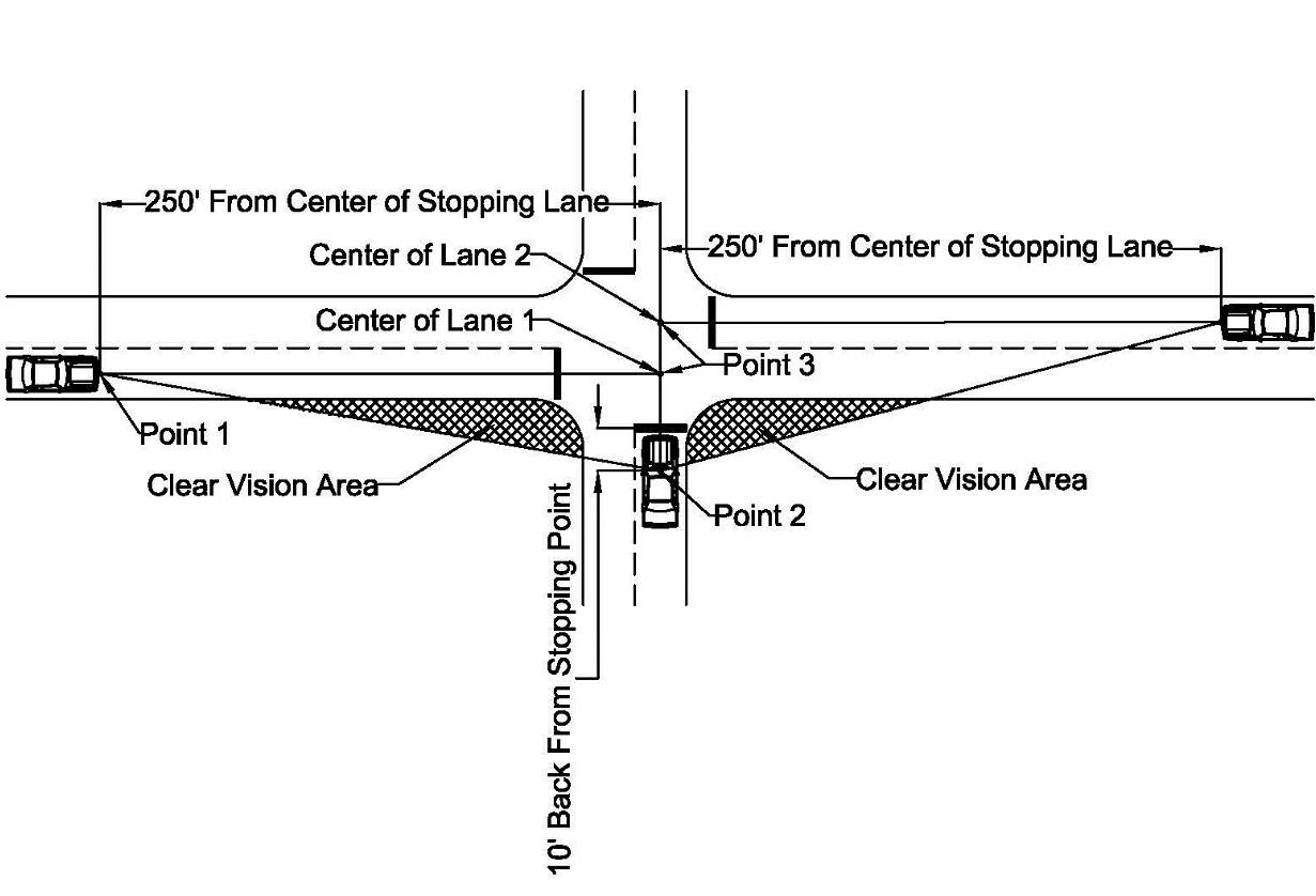 Boulevard Cross Street
 FRONT WALL
The wall of a building that faces either a public street or the required front yard, which will be determined by an Administer/Zoning Administer, if its location is unclear due to the orientation or layout of the structure. Buildings on corner lots may be determined to have two front walls if the building is designed to have two front facades.
GARAGE SALE
The sale or offering for sale to the general public, items of personal property on any portion of a lot in a residential zoning district, either within or outside of a structure to include yard sales and porch sales.
LONG TERM BUSINESSES
Owner occupied structures/ leases of twelve (12) months or longer.
NIT
A unit of measurement of brightness (luminance), which is the measure of the light emanating from an object with respect to the size and is the term used to quantify Electronic Message Sign brightness. The unit of measurement for luminance is nits, which is the total amount of light emitted from a sign divided by the surface area of the sign (candelas per square meter (cd/m2)).
OTHER REQUIRED APPROVALS
Approvals required by the appropriate governing bodies (ex: Plan Commission, Board of Zoning Appeals, Board of Public Works and Safety, Indiana Department of Transportation, Home Owners Associations, etc.).
PROPRIETARY SYMBOL
A graphic, logo type, or other representation of a trademark or service mark or otherwise associated in content or style, color, or other aspect of its appearance with a particular organization or a particular product or service identified with or promoted by an organization. For example, a graphic of a sea shell would be considered a proprietary symbol if it were stylized to resemble the logotype of Shell Oil, and a graphic of an apple would be considered a proprietary symbol if it were stylized to resemble the logo of the Apple Computer Company.
PUBLIC RIGHT-OF-WAY
Right-of-way is an area of land over which people and goods have the right to pass or travel. A public right-of-way grants passage to all and provides the right to park registered vehicles in accordance with local parking restrictions. A public right-of-way is a form of easement typically dedicated to the City during subdivision for public use. A right-of-way is not part of the adjacent parcels; the right-of-way boundary usually coincides with adjacent parcel property lines. A right-of-way may also be deeded, in which case, it is not an easement, but land owned in fee by the City. The City controls all public right-of-ways in the City except for State Road 8, which is State of Indiana right-of-way. Although most right-of-ways dedicated to the City are used for public streets, there are also undeveloped right-of-ways.
SHORT TERM BUSINESS
A temporary, transient, or seasonal business with a lease of less than twelve (12) months. (Examples: fireworks, specialty/seasonal items, and temporary auto/tool sales.)
SIGN
Any visual, graphic board, device, structure, or part thereof used for advertising, display, or publicity purposes, designed or used to communicate (primarily with words, numbers, characters, and/or proprietary symbols) a verbal and/or visual message.
Signs placed or erected by governmental agencies for the purposes of showing street names or traffic directions or regulations for other governmental purposes shall not be included herein.
SIGN, AREA/FACE/PANEL
The area of the sign that is intended for or can be utilized for communication purposes or the surface of any sign against, through, or upon which the message or copy of the sign is attached, displayed, exhibited, or that draws attention to the sign.
SIGN, AWNING
A sign displayed on an awning.
SIGN, BANNER
Any horizontal or vertical hanging sign possessing characters, letters, illustrations, or ornamentations applied to paper, plastic, or fabric of any kind. This classification shall not include plastic or paper signs, which are permanently attached within a rigid frame and are intended to be used as a permanent sign. National flags, flags of political subdivisions, and symbolic flags of any institution or business shall not be considered banners for purpose of this chapter.
SIGN, BILLBOARD
Any large structure affixed to the surface of the land or any building, tower, or other structures designed, arranged, used, or intended to be used for outdoor advertising, or where display space is purchased or rented for general advertising purposes.
SIGN, CANOPY
A sign displayed on a canopy.
SIGN, CHANGEABLE COPY
Any poster board, bulletin board, neon sign, screen, surface, or wall sign, with characters, letters, or illustrations affixed thereto or thereon, by any method or means whatsoever, that can be changed, rearranged, or altered without changing the face of the poster board, bulletin board, neon sign, screen, surface, or wall sign.
SIGN, CHANGEABLE COPY AREA (MANUAL)
A sign or portion of a sign that allows for periodic changes in the sign message by manual means, not including painted or poster billboards or similar signs.
SIGN, CHANGEABLE COPY AREA (MECHANICAL)
A sign or portion of a sign that allows for periodic changes in the sign message by mechanical means, such as multi-prism or tri-vision outdoor advertising signs.
SIGN, CONSTRUCTION
Any sign announcing the names of architects, engineers, contractors, or other individuals or firms involved with the construction, alteration, or repair of a building, enterprise, or purpose for which the project is intended on the site where the sign is placed, together with other information included thereon.
SIGN, DISSOLVE
A mode of message transition on an Electronic Message Sign accomplished by varying the light intensity or pattern, where the first message gradually appears to dissipate and lose legibility simultaneously with the gradual appearance and legibility of the second message.
SIGN, DOUBLE FACED
A sign having two display surfaces, not necessarily displaying the same copy, which are usually parallel, back to back, and generally not more than twenty-four (24) inches apart.
SIGN, ELECTRONIC MESSAGE
A sign or portion of a sign that allows for periodic changes in the sign message by electronic means, such as an electronic message (text) center, video display, projection screen, or similar technology.
SIGN, ENTRANCE
A sign used to identify or introduce a platted subdivision or a planned unit development/district (PUD) with the intention of providing knowledge about the complete platted subdivision or PUD and not a single entity or unit. An entrance sign could include a landscaping design plan or dedicated designed space on which a physical sign or structure could be placed.
SIGN, EXPIRED
A sign for a business no longer in operation, a garage sale sign displayed after the conclusion of the sale, a political campaign sign displayed after the date of election, a real estate sign displayed after the closing of a sale, a construction sign displayed after the completion of construction, or an event sign after the event or activity has been cancelled.
SIGN FADE
A mode of message transition on an Electronic Message Sign accomplished by varying the light intensity, where the first message gradually reduces intensity to the point of not being legible and the subsequent message gradually increases intensity to the point of legibility.
SIGN, FREESTANDING/GROUND
A sign supported by one (1) or more uprights, braces, frame, mast, pole, pylon, or similar support or bases placed upon or affixed in the ground, that is not attached to a building, structure, or similar construction. A freestanding/ground sign would include pole signs, monument signs, and free-standing signs permanently fixed to the ground.
SIGN, FLASHING
A sign that flashes or appears to flash by a powered light source more than two times per second.
SIGN, FRAME
A complete, static display screen on an Electronic Message Sign
SIGN, FRAME EFFECT
A visual effect on an Electronic Message Sign applied to a single frame to attract the attention of viewers.
SIGN, GOVERNMENT
Any temporary or permanent sign erected and maintained by the city, county, state, or federal government for traffic direction or for designation and/or direction to any school, hospital, historical site, or public service, property, or facility.
SIGN, HOME OCCUPATION
A sign used to identify a home occupation taking place within a primarily residential building as per the Zoning Code.
SIGN, IDENTIFICATION
A sign, which is limited to the name and/or address of a building, institution, or person; to the activity carried on in the building or institution; the occupation of the person; and/or logo.
SIGN, ILLEGAL
A sign, which does not meet the requirements of this chapter and has not received legal non-conforming status.
SIGN, INCIDENTAL/INFORMATIONAL
A small on premises auxiliary sign, containing information relative to expediting pedestrian or vehicular traffic flow and parking or containing other essential or nonessential information, such as directions on or to a property, historical information, parking limitations, traffic information, warnings, or other similar information. Direction and similar incidental signs may also include logos or other proprietary symbols.
SIGN, LANDMARK
A sign designated as such by a federal, state, or local historical agency, or similar agency by virtue of exceptional or unique design or cultural, design, historic, or other similar community value.
SIGN, NAME PLATE
A sign for residential dwelling units identifying the name of the occupants and/or the address of the premises.
SIGN, NON-CONFORMING
A sign, which was erected legally but which does not comply with subsequently enacted sign restrictions and regulations. A sign, which does not conform to the sign code requirements but for which a special permit has been issued.
SIGN, OFF PREMISES
Any sign advertising a business, use, activity, product, or merchandise not sold, handled, or occurring in/on the property where the sign is located.
SIGN, ON PREMISES
Any sign advertising a business, use, activity, product, or merchandise that is sold, handled, or occurring in/on the property where the sign is located.
SIGN, PAINTED GRAPHICS
Any advertisement painted directly onto the wall of a building.
SIGN, POLE/PYLON
A sign, which is supported by one or more uprights or braces in the ground with the sign surface located at a minimum height of ten (10) feet above grade level.
SIGN, POLITICAL
Any temporary sign pertaining to any election or referendum, carrying the picture or name of a person seeking election or appointment to a public office, or identifying and urging voter support for or opposition to a particular issue, political party, or candidate for public office.
SIGN, PORTABLE
Any sign not permanently affixed to a building, structure, or the ground and designed to be moved from place to place, or a structure affixed to a chassis equipped with wheel and axle or other means of mobility. An allowable characteristic of a portable sign is one that the space provided for advertising messages may be changed at will by the replacement of lettering or symbols.
SIGN, PROJECTING
A sign characterized by its attachment at an angle, which is typically ninety (90) degrees to the primary face of the building as opposed to being mounted flat on the surface of a building (a Wall Sign).
SIGN, PUBLIC EVENT
A temporary sign announcing a function of public interest. This does not include retail sale signs.
SIGN, REAL ESTATE/AUCTION
Any sign advertising the sale, rental, lease, or auction of the premises or part of the premises on which the sign is located.
SIGN, SCROLL
A mode of message transition on an electronic sign where the message appears to move vertically across the display surface
SIGN, SUBDIVISION SALE
A sign advertising the sale of available lots or buildings within a previously plotted subdivision.
SIGN, STREET BANNER
A Horizontal Banner, spanning the right-of-way of a street.
SIGN, TEMPORARY (SHORT TERM)
A sign displayed upon the same lot for up to thirty (30) days in any calendar year in conjunction with certain activities or events. Examples are business openings, closings, or relocations; business special sales; short-term construction or renovation projects; garage sales; institutional (civic, educational, governmental, non-profit/philanthropic, religious or similar institution or organization) campaigns or events; the offering of real properties or items on a property for auction; and other similar short-term activities or events.
SIGN, TEMPORARY (LONG TERM)
A sign displayed upon the same lot for at least thirty (30) days but no more than 180 days in any calendar year in conjunction with certain activities or events. Examples are long-term construction or renovation projects, “coming soon” development projects, and similar activities or events.
SIGN, TENANT IDENTIFICATION
A sign used solely to identify the owner or leaser of property or building.
SIGN, TRANSITION
A visual effect used on an Electronic Message Sign to change from one message to another.
SIGN, TRAVEL
A mode of message transition on an Electronic Message Sign where the message appears to move horizontally across the display surface
SIGN, WALL
Any sign attached to, mounted on, or displayed upon the wall of a building or similar structure, surface, or construction.
SIGN ALTERATION
Any change to an existing sign or sign structure, excluding a change to a sign face in an existing sign cabinet or a sign conversion.
SIGN CLASSIFICATON
Use, style, or unique material to include, but not limited to: banner, identification, informational, directional, billboard, reader board, electric message, inflatable, flags, and pennant signs that may be incorporated into any Sign Type (See definition).
SIGN COPY
The wording on a sign surface in either permanent or removable letter form.
SIGN TYPE
How the sign is constructed and attached to a structure, support system, or other physical structure, which includes, but is not limited to: Ground/Free Standing Sign, Wall Sign, Awning Sign, Canopy Sign, Vertical/Horizontal Banners, and Street Banner.
FRONT WALL
The wall of a building that faces either a public street or the required front yard, which will be determined by an Administer/Zoning Administer, if its location is unclear due to the orientation or layout of the structure. Buildings on corner lots may be determined to have two front walls if the building is designed to have two front facades.
GARAGE SALE
The sale or offering for sale to the general public, items of personal property on any portion of a lot in a residential zoning district, either within or outside of a structure to include yard sales and porch sales.
LONG TERM BUSINESSES
Owner occupied structures/ leases of twelve (12) months or longer.
NIT
A unit of measurement of brightness (luminance), which is the measure of the light emanating from an object with respect to the size and is the term used to quantify Electronic Message Sign brightness. The unit of measurement for luminance is nits, which is the total amount of light emitted from a sign divided by the surface area of the sign (candelas per square meter (cd/m2)).
OTHER REQUIRED APPROVALS
Approvals required by the appropriate governing bodies (ex: Plan Commission, Board of Zoning Appeals, Board of Public Works and Safety, Indiana Department of Transportation, Home Owners Associations, etc.).
PROPRIETARY SYMBOL
A graphic, logo type, or other representation of a trademark or service mark or otherwise associated in content or style, color, or other aspect of its appearance with a particular organization or a particular product or service identified with or promoted by an organization. For example, a graphic of a sea shell would be considered a proprietary symbol if it were stylized to resemble the logotype of Shell Oil, and a graphic of an apple would be considered a proprietary symbol if it were stylized to resemble the logo of the Apple Computer Company.
PUBLIC RIGHT-OF-WAY
Right-of-way is an area of land over which people and goods have the right to pass or travel. A public right-of-way grants passage to all and provides the right to park registered vehicles in accordance with local parking restrictions. A public right-of-way is a form of easement typically dedicated to the City during subdivision for public use. A right-of-way is not part of the adjacent parcels; the right-of-way boundary usually coincides with adjacent parcel property lines. A right-of-way may also be deeded, in which case, it is not an easement, but land owned in fee by the City. The City controls all public right-of-ways in the City except for State Road 8, which is State of Indiana right-of-way. Although most right-of-ways dedicated to the City are used for public streets, there are also undeveloped right-of-ways.
SHORT TERM BUSINESS
A temporary, transient, or seasonal business with a lease of less than twelve (12) months. (Examples: fireworks, specialty/seasonal items, and temporary auto/tool sales.)
SIGN
Any visual, graphic board, device, structure, or part thereof used for advertising, display, or publicity purposes, designed or used to communicate (primarily with words, numbers, characters, and/or proprietary symbols) a verbal and/or visual message.
Signs placed or erected by governmental agencies for the purposes of showing street names or traffic directions or regulations for other governmental purposes shall not be included herein.
SIGN, AREA/FACE/PANEL
The area of the sign that is intended for or can be utilized for communication purposes or the surface of any sign against, through, or upon which the message or copy of the sign is attached, displayed, exhibited, or that draws attention to the sign.
SIGN, AWNING
A sign displayed on an awning.
SIGN, BANNER
Any horizontal or vertical hanging sign possessing characters, letters, illustrations, or ornamentations applied to paper, plastic, or fabric of any kind. This classification shall not include plastic or paper signs, which are permanently attached within a rigid frame and are intended to be used as a permanent sign. National flags, flags of political subdivisions, and symbolic flags of any institution or business shall not be considered banners for purpose of this chapter.
SIGN, BILLBOARD
Any large structure affixed to the surface of the land or any building, tower, or other structures designed, arranged, used, or intended to be used for outdoor advertising, or where display space is purchased or rented for general advertising purposes.
SIGN, CANOPY
A sign displayed on a canopy.
SIGN, CHANGEABLE COPY
Any poster board, bulletin board, neon sign, screen, surface, or wall sign, with characters, letters, or illustrations affixed thereto or thereon, by any method or means whatsoever, that can be changed, rearranged, or altered without changing the face of the poster board, bulletin board, neon sign, screen, surface, or wall sign.
SIGN, CHANGEABLE COPY AREA (MANUAL)
A sign or portion of a sign that allows for periodic changes in the sign message by manual means, not including painted or poster billboards or similar signs.
SIGN, CHANGEABLE COPY AREA (MECHANICAL)
A sign or portion of a sign that allows for periodic changes in the sign message by mechanical means, such as multi-prism or tri-vision outdoor advertising signs.
SIGN, CONSTRUCTION
Any sign announcing the names of architects, engineers, contractors, or other individuals or firms involved with the construction, alteration, or repair of a building, enterprise, or purpose for which the project is intended on the site where the sign is placed, together with other information included thereon.
SIGN, DISSOLVE
A mode of message transition on an Electronic Message Sign accomplished by varying the light intensity or pattern, where the first message gradually appears to dissipate and lose legibility simultaneously with the gradual appearance and legibility of the second message.
SIGN, DOUBLE FACED
A sign having two display surfaces, not necessarily displaying the same copy, which are usually parallel, back to back, and generally not more than twenty-four (24) inches apart.
SIGN, ELECTRONIC MESSAGE
A sign or portion of a sign that allows for periodic changes in the sign message by electronic means, such as an electronic message (text) center, video display, projection screen, or similar technology.
SIGN, ENTRANCE
A sign used to identify or introduce a platted subdivision or a planned unit development/district (PUD) with the intention of providing knowledge about the complete platted subdivision or PUD and not a single entity or unit. An entrance sign could include a landscaping design plan or dedicated designed space on which a physical sign or structure could be placed.
SIGN, EXPIRED
A sign for a business no longer in operation, a garage sale sign displayed after the conclusion of the sale, a political campaign sign displayed after the date of election, a real estate sign displayed after the closing of a sale, a construction sign displayed after the completion of construction, or an event sign after the event or activity has been cancelled.
SIGN FADE
A mode of message transition on an Electronic Message Sign accomplished by varying the light intensity, where the first message gradually reduces intensity to the point of not being legible and the subsequent message gradually increases intensity to the point of legibility.
SIGN, FREESTANDING/GROUND
A sign supported by one (1) or more uprights, braces, frame, mast, pole, pylon, or similar support or bases placed upon or affixed in the ground, that is not attached to a building, structure, or similar construction. A freestanding/ground sign would include pole signs, monument signs, and free-standing signs permanently fixed to the ground.
SIGN, FLASHING
A sign that flashes or appears to flash by a powered light source more than two times per second.
SIGN, FRAME
A complete, static display screen on an Electronic Message Sign
SIGN, FRAME EFFECT
A visual effect on an Electronic Message Sign applied to a single frame to attract the attention of viewers.
SIGN, GOVERNMENT
Any temporary or permanent sign erected and maintained by the city, county, state, or federal government for traffic direction or for designation and/or direction to any school, hospital, historical site, or public service, property, or facility.
SIGN, HOME OCCUPATION
A sign used to identify a home occupation taking place within a primarily residential building as per the Zoning Code.
SIGN, IDENTIFICATION
A sign, which is limited to the name and/or address of a building, institution, or person; to the activity carried on in the building or institution; the occupation of the person; and/or logo.
SIGN, ILLEGAL
A sign, which does not meet the requirements of this chapter and has not received legal non-conforming status.
SIGN, INCIDENTAL/INFORMATIONAL
A small on premises auxiliary sign, containing information relative to expediting pedestrian or vehicular traffic flow and parking or containing other essential or nonessential information, such as directions on or to a property, historical information, parking limitations, traffic information, warnings, or other similar information. Direction and similar incidental signs may also include logos or other proprietary symbols.
SIGN, LANDMARK
A sign designated as such by a federal, state, or local historical agency, or similar agency by virtue of exceptional or unique design or cultural, design, historic, or other similar community value.
SIGN, NAME PLATE
A sign for residential dwelling units identifying the name of the occupants and/or the address of the premises.
SIGN, NON-CONFORMING
A sign, which was erected legally but which does not comply with subsequently enacted sign restrictions and regulations. A sign, which does not conform to the sign code requirements but for which a special permit has been issued.
SIGN, OFF PREMISES
Any sign advertising a business, use, activity, product, or merchandise not sold, handled, or occurring in/on the property where the sign is located.
SIGN, ON PREMISES
Any sign advertising a business, use, activity, product, or merchandise that is sold, handled, or occurring in/on the property where the sign is located.
SIGN, PAINTED GRAPHICS
Any advertisement painted directly onto the wall of a building.
SIGN, POLE/PYLON
A sign, which is supported by one or more uprights or braces in the ground with the sign surface located at a minimum height of ten (10) feet above grade level.
SIGN, POLITICAL
Any temporary sign pertaining to any election or referendum, carrying the picture or name of a person seeking election or appointment to a public office, or identifying and urging voter support for or opposition to a particular issue, political party, or candidate for public office.
SIGN, PORTABLE
Any sign not permanently affixed to a building, structure, or the ground and designed to be moved from place to place, or a structure affixed to a chassis equipped with wheel and axle or other means of mobility. An allowable characteristic of a portable sign is one that the space provided for advertising messages may be changed at will by the replacement of lettering or symbols.
SIGN, PROJECTING
A sign characterized by its attachment at an angle, which is typically ninety (90) degrees to the primary face of the building as opposed to being mounted flat on the surface of a building (a Wall Sign).
SIGN, PUBLIC EVENT
A temporary sign announcing a function of public interest. This does not include retail sale signs.
SIGN, REAL ESTATE/AUCTION
Any sign advertising the sale, rental, lease, or auction of the premises or part of the premises on which the sign is located.
SIGN, SCROLL
A mode of message transition on an electronic sign where the message appears to move vertically across the display surface
SIGN, SUBDIVISION SALE
A sign advertising the sale of available lots or buildings within a previously plotted subdivision.
SIGN, STREET BANNER
A Horizontal Banner, spanning the right-of-way of a street.
SIGN, TEMPORARY (SHORT TERM)
A sign displayed upon the same lot for up to thirty (30) days in any calendar year in conjunction with certain activities or events. Examples are business openings, closings, or relocations; business special sales; short-term construction or renovation projects; garage sales; institutional (civic, educational, governmental, non-profit/philanthropic, religious or similar institution or organization) campaigns or events; the offering of real properties or items on a property for auction; and other similar short-term activities or events.
SIGN, TEMPORARY (LONG TERM)
A sign displayed upon the same lot for at least thirty (30) days but no more than 180 days in any calendar year in conjunction with certain activities or events. Examples are long-term construction or renovation projects, “coming soon” development projects, and similar activities or events.
SIGN, TENANT IDENTIFICATION
A sign used solely to identify the owner or leaser of property or building.
SIGN, TRANSITION
A visual effect used on an Electronic Message Sign to change from one message to another.
SIGN, TRAVEL
A mode of message transition on an Electronic Message Sign where the message appears to move horizontally across the display surface
SIGN, WALL
Any sign attached to, mounted on, or displayed upon the wall of a building or similar structure, surface, or construction.
SIGN ALTERATION
Any change to an existing sign or sign structure, excluding a change to a sign face in an existing sign cabinet or a sign conversion.
SIGN CLASSIFICATON
Use, style, or unique material to include, but not limited to: banner, identification, informational, directional, billboard, reader board, electric message, inflatable, flags, and pennant signs that may be incorporated into any Sign Type (See definition).
SIGN COPY
The wording on a sign surface in either permanent or removable letter form.
SIGN TYPE
How the sign is constructed and attached to a structure, support system, or other physical structure, which includes, but is not limited to: Ground/Free Standing Sign, Wall Sign, Awning Sign, Canopy Sign, Vertical/Horizontal Banners, and Street Banner.
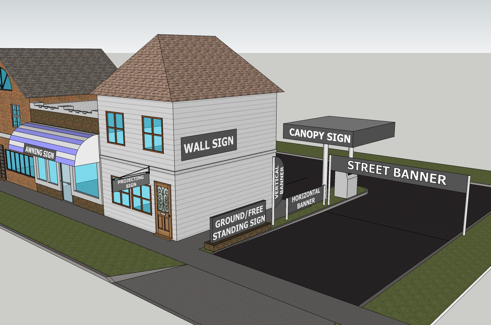 TOURIST AND EVENT ORIENTED DIRECTIONAL (TEOD) SIGNS
Directional signs (either temporary or permanent) that will be located in the road right-of-way for qualifying attractions, such as historical sites, museums, churches, and non-profit organizations.
VISUAL DISPLAY
Displays other than signs intended to draw attention to a property or create visual effects that are at least partially visible from the ground level on adjacent developments. Visual displays include flags, holiday decorations, strings of lights, and other similar displays. Balloons of up to eighteen (18) inches in diameter, which do not meet the definition of sign shall not be considered a visual display.
WEEK
Monday through Sunday.
TOURIST AND EVENT ORIENTED DIRECTIONAL (TEOD) SIGNS
Directional signs (either temporary or permanent) that will be located in the road right-of-way for qualifying attractions, such as historical sites, museums, churches, and non-profit organizations.
VISUAL DISPLAY
Displays other than signs intended to draw attention to a property or create visual effects that are at least partially visible from the ground level on adjacent developments. Visual displays include flags, holiday decorations, strings of lights, and other similar displays. Balloons of up to eighteen (18) inches in diameter, which do not meet the definition of sign shall not be considered a visual display.
WEEK
Monday through Sunday.
150.430 GENERAL PROVISION FOR ALL SIGNS
E)
Any placement of a sign on property lying within the jurisdiction of the Auburn Plan Commission shall require the permission of the property owner.
F)
Administrator/Zoning Administrator approval is required for the issuance of a sign permit.
G)
All signs requiring a permit shall have locations approved by the Administrator/Zoning Administrator, prior to issuance of a permit, to assure elimination of any conflicts with existing or future infrastructure.
H)
All signs, except incidental signs and those that are an integral part of another structure or are stated in 150.440 shall require a sign permit as provided in 150.480.
I)
Two (2) incidental signs are permitted per frontage in front of the building line not to exceed a total of eight (8) square feet in area (excluding those required to explain gas pump operation and government required signs). An unlimited number of incidental signs are permitted behind the building line not to exceed sixteen (16) square feet in area. Incidental signs are permitted in A-1, C-1, C-2, I-1, and I-2 Districts.
J)
All conforming signs, either of a temporary or permanent nature, shall be constructed or maintained in a presentable, well-kept, and recognizable state for the life of the sign.
1)
Any conforming sign that is or becomes rundown or in a condition of disrepair whereas, it is no longer discernible or recognizable as a sign, may result in fines and the removal of the sign.
2)
Said condition shall exist when the area of the sign’s face is determined to be in excess of thirty percent (30%) destroyed or damaged or the sign’s structure is no longer in a safe condition. Said determination shall be made by the Administrator/Zoning Administrator.
K)
Any non-conforming sign that is or becomes rundown or in a condition of disrepair whereas, it is no longer discernible or recognizable as a sign, shall be removed from the premises by the owner of said sign.
1)
Said condition shall exist when the area of the sign’s face is determined to be in excess of thirty percent (30%) destroyed or damaged or the sign’s structure is no longer in a safe condition. Said determination shall be made by the Administrator/Zoning Administrator.
L)
Any sign that advertises a product or service no longer available on the premises of a business that has closed permanently or moved from the premises shall be removed by the owner of such premises.
M)
Maximum Number of Permitted Temporary Signs:
1) A Single Family Residential Structure or Stand Alone Agricultural/Industrial/Commercial Business is allowed three (3) total signs.
2) A Multi-Family Residential Development or Agricultural/Industrial/Commercial Business Shopping Center is allowed three (3) total signs per street frontage.
N)
Visual displays, when promoting a product or sales event, business/commercial activity, or public/cultural activity, may be considered a sign requiring a sign permit (See 150.420, Definition of Visual Display).
O)
Any vehicle, boat, or trailer being used as advertising for Special Event, Garage Sale, Subdivision Construction, or Agricultural/Commercial/Industrial Sales/Promotional Event signs parked on private property are considered temporary signs and fall under the provisions of section 150.450 Temporary/Portable Sign Regulations.
P)
A permit must be secured when the ownership or lessee of the property upon which a sign is located changes. An exception may be made by the Administrator/Zoning Administrator if the name of the business does not change and the size or location of the sign is not altered.
Q)
Any sign authorized in this subchapter is allowed to contain non-commercial copy in lieu of other copy.
150.440 PROHIBITED SIGNS AND LOCATIONS
A)
No sign shall be placed within, over hanging, or encroaching on any public utility easement unless authorized by the appropriate public utility legal representative and the City’s Board of Public Works and Safety
B)
No sign shall be located within, overhanging, or encroaching on any public right-of-way, unless authorized by the City’s Board of Public Works and Safety and as regulated in 150.470.07 Street Banners.
C)
No sign of a permanent or temporary nature shall be affixed to a fence, tree, or utility structure in the public right-of-way.
D)
No sign shall be placed within any public drainage easement unless authorized by the DeKalb County Drainage Board.
E)
No signs shall be located on or attached to physical features such as parking lot light poles, flag poles, vent pipes, permanent sign structures, utility poles, trees, and/or fences within ten (10) feet of road right-of-way in the C-1, C-2, I-1, and I-2 Zoning Districts.
F)
Persons carrying signs or dressed in character as a means of advertising a product, sales event or, special event are prohibited within any public right-of-way unless obtaining prior permission from the City’s Board of Public Works and Safety and any other local, state, and federal agency as required. A sign permit must be obtained.
G)
Any sign that is flashing, strobing, blinking, rotating, or blinding to pedestrians or occupants of motor vehicles shall be prohibited.
H)
Roofs – No sign shall project more than three (3) feet above the roof-line or higher than the maximum height of the zoning designation in which the building is located.
I)
No display or advertising sign shall be attached to the standard of a freestanding/ground sign other than the display surface originally constructed as a part of such sign.
J)
Any sign that is deemed a traffic hazard for reason of obstructing the view of an approaching road or intersection, railroad, school playground, park, pedestrian crosswalk, or any other situation that may endanger the health and welfare of any pedestrian or occupant of any vehicle shall be prohibited.
K)
Clear Vision Triangle – No sign (temporary or permanent) over three (3) feet in total height will be allowed within the Clear Vision Triangle (See 150.420, the Definitions section). Signs less than three (3) feet shall meet the requirements of the zoning district in which it is to be located or placed.
150.450 DESIGN STANDARDS
C)
Awning Signs
1)
Any lettering or graphics attached to the Awning (See 150.420, Definition of Awning) of a building will be counted as an Awning Sign.
2)
Awning Signs will be counted toward the maximum allowable area of Wall Signs (See 150.434 G)).
3)
No individual Awning may have more than fifty percent (50%) of its visible area used for Signs
4)
Only the sign area of an Awning Sign may be indirectly illuminated.
D)
Canopy Signs
1)
Canopy Signs shall be permitted in the A-1, C-1, C-2, I-1, and I-2 Districts.
2)
Sign area on a canopy shall not exceed twenty percent (20%) of the area of the individual façade of the canopy, which is calculated by multiplying the height by the length of the visible edge of the canopy.
3)
Any Canopy Sign must be an integral part of the canopy to which it is attached.
4)
Any single side of a canopy shall have no more than two (2) permanent signs attached to it.
5)
Only the sign area of a Canopy Sign may be illuminated.
E)
Electronic Message Signs are permitted and may be incorporated as part of a Ground/Free Standing or Wall mounted permanent signs with the following restrictions:
1)
Static Message Signs
a)
Operational Limitation. Such displays shall contain static messages only, and shall not have movement, or the appearance or optical illusion of movement, of any part of the sign structure, design, or pictorial segment of the sign, including the movement or appearance of movement, of an illumination.
b)
Minimum Display Time. Each message on the sign must be displayed for a minimum of eight (8) seconds.
c)
Message Change Sequence. A maximum of three tenths (0.3) seconds shall be allowed with no image displayed between each message displayed on the sign.
d)
Light Intensity Change. No flashing, strobing, scintillating, or variation of light intensity effects where the effect takes place more than two (2) times per second.
e)
Sign Design. The design of the copy cannot be created in such a way as to be a distraction to motorists.
f)
Requirements. The sign must meet all other criteria for the zoning district in which it is located.
2)
Motion Message Signs
a)
Operational Limitation. Such displays shall be limited to static displays, messages that appear to disappear from the display through dissolve, fade, travel or scroll modes, or similar transitions and frame effects that have text, animated graphics or images that appear to move or change in size, or be revealed sequentially rather that all at once.
b)
Minimum Display Time. Each message on the sign must be displayed for a minimum of two (2) Seconds.
c)
Message Transition Sequence. A maximum of one (1) second shall be allowed as transition time between messages.
d)
Light Intensity Change. No flashing, strobing, scintillating, or variation of light intensity effects where the effect takes place more than two (2) times per second.
e)
Sign Design. The design of the copy cannot be created in such a way as to be a distraction to motorists.
f)
Requirements. The sign must meet all other criteria for the zoning district in which it is located.
g)
Permit. Motion Message Signs must be approved by the City of Auburn Planning Commission
3)
Video Message Signs
a)
Operational Limitation. A sign capable of displaying words, symbols, figures, or images that can be electronically or mechanically changed by remote or automatic means, including animated graphics and videos.
b)
Location. Video Message Signs are only allowed in non-motor vehicular areas and must not be visible from any motor vehicle traveled public street.
c)
Light Intensity Change. No flashing, strobing, scintillating, or varying of light intensity effects where the effect takes place more than two (2) times per second.
d)
Sign Design. The design of the copy cannot be created in such a way as to be a distraction to motorists.
e)
Requirements. The sign must meet all other criteria for the zoning district in which it is located.
f)
Permit. Video Message Signs must be approved by the City of Auburn Planning Commission
4)
Any Electronic Message Sign that malfunctions, fails, or ceases to operate in its usual or normal programmed manner, causing motion, movement, flashing, or any similar effects, shall be restored to its normal operation, conforming with this section within forty-eight (48) hours unless the Administrator/Zoning Administrator considers such malfunction to be a hazard to the health, safety, and welfare of the public and orders the sign to be turned off, disconnected, or disabled.
5)
Electronic Message Signs are permitted in the A-1, C-1, C-2, I-1, and I-2 Districts only. The distance between an Electronic Message Sign and any “OS” District, “R” District, “MH” District, locations listed on the National Register of Historic Places and/or Register of Indiana Historic Sites and Historic Structures, or school shall be no less than three hundred (300) feet (measured from the center of the horizontal width of the sign). Not to be located within the Clear Vision Triangle.
6)
Electronic Message Boards are not permitted within the designated Historic Downtown Business District.
7)
Display Light Intensity: Electronic Message Signs must meet all industry standards for brightness and illumination. The illumination average will be limited to a maximum of five thousand (5,000) NITs (See150.420, Definition of NIT) during daylight hours and will be reduced to five hundred (500) NITs from a half hour before sunset to a half hour after sunrise. All Electronic Message Signs must be factory-certified as incapable of exceeding these standards and include an ambient light sensor. Proof of factory-certification must be submitted to staff when submitting the Sign Permit application.
F)
Ground/Free Standing Signs
1)
Setback: Shall be set back a minimum of one (1) foot for residential and two (2) feet for all other zoning districts from the front property line and follow the setback standards within that zoning district.
2)
Base and Exposed Foundations for all free standing signs within all zoning districts except I-2/Heavy Industrial Districts shall be covered or wrapped with a finished material so as not to expose the raw structural feature (examples could be: vinyl, brick, wood, or other similar man-made materials). Said determination shall be made by the Administrator/Zoning Administrator.
G)
Street Banner Signs
1)
Banners will only be approved to promote historical, ethnic, or cultural civic events or activities that the City believes are of particular interest or benefit to the City of Auburn or an area thereof. Banners shall be used to celebrate the historical, ethnic, or cultural heritage of the City or neighborhood district therein.
2)
Banners are not to be used for commercial advertising or to advertise or promote political candidates, parties, or issues as the City does not wish to create a forum for the expression of ideas or opinions and wishes to avoid the controversies or disruptions that they cause.
3)
Street Banner Approvals
a)
The City of Auburn reserves the right to refuse any and all requests.
b)
City Sponsored Events have top priority for approval.
c)
All other Banner applications will be approved on a “first come, first served” basis.
i)
Submissions in consecutive years will be given first priority.
4)
The City of Auburn cannot be held responsible for any damage caused by the failure of a Street Banner Sign.
5)
The City of Auburn reserves the right to remove any Street Banner Sign without notice. No refund of application fees will be given for early removal of Street Banner Sign.
H)
Projecting Signs
1)
One Projecting Sign is allowed per Agricultural/Commercial/Industrial Business.
2)
The Sign Area of the Projecting Sign face may be a maximum of sixteen (16) square feet per face.
3)
Projecting Signs will be counted toward the maximum allowable area of Wall Signs (See 150.434 G)).
4)
The minimum distance between the bottom of the sign and the existing grade shall be nine (9) feet and may not be higher than the roof line of the building to which it is attached.
5)
No Projecting Sign shall over-hang a public utility easement or right-of-way without authority of the appropriate public utility legal representative and/or the City Board of Public Works and Safety.
I)
Tourist and Event Oriented Directional (TEOD) Signs
1)
Signs are managed by the Administrator/Zoning Administrator and the appropriate governing bodies
2)
Sign installation shall take place only after obtaining permission from the City’s Board of Works and Public Safety and any other applicable entities.
3)
Application to the Board of Works and Public Safety is to be made through the Department of Building, Planning and Development on a form supplied by the department.
4)
Signs may be ordered through the Street Department at the expense of the applicant, or applicants may provide a Street Department approved sign.
5)
Signs shall be installed by the Street Department. The final quantity, location, and placement of sign will remain at the discretion of the Board of Public Works and Safety.
6)
Placement of TEOD Signs on corner commercial building walls will be allowed, but must meet the zoning and design criteria of the zoning district in which they are located.
7)
An applicant for a TEOD sign agrees to abide by any and all conditions and/or restrictions placed on the installation of the sign,
8)
An applicant for a TEOD sign shall be responsible for the cost of maintenance and replacement if their sign must be replaced for any reason.
J)
Wall Signs
1)
The total accumulated area of all Wall Signs is limited to three (3) square feet of area per lineal front foot of the building unless limited further according to a Sign Regulation’s Maximum Area, Height, or Width.
2)
A Wall Sign shall not protrude greater than twelve (12) inches from the side of the building.
3)
A twenty-five percent (25%) increase in allowed Wall Sign area may be granted by the Board of Zoning Appeals (BZA).
4)
For corner lots, the building front is determined by the building side that coincides with the building’s address.
150.460 EXCEPTIONS TO SIGN REGULATIONS
Any person responsible for the placement of a sign under this section shall be responsible for its removal within forty-eight (48) hours after the activity has closed or within a reasonable period of time to be established by the Administrator/Zoning Administrator when extenuating circumstances may exist. The following signs shall be excluded from the regulations of this subchapter:
A)
Historic Identification Signs: Signs for properties designated by a Federal, State, or Local government as a historic location, site, or landmark do not require a Sign Permit as long as the sign is does not exceed twelve (12) square feet.
B)
Governmental or other signs required by law: Any sign required by the Government or a Federal, State, or Local law are permitted without a Sign Permit regardless of the size, height, or location and may be illuminated if the law requires it.
C)
"No Trespassing", "No Dumping", "No Parking", and "No Hunting" signs are exempt from the requirement of obtaining a permit as long as they do not exceed the sign requirements of the zoning district in which they are located.
D)
Persons carrying signs or dressed in character as a non-commercial means of public expression within the public right-of-way are exempt from obtaining a sign permit but must follow any local, state, and federal regulations.
E)
Downtown District Signs will be exempt from this subchapter if/when a new downtown district ordinance is created and will be subject to the newly created downtown district’s zoning requirements.
F)
Future overlay districts created for sign unification will be exempt from this subchapter once the overlay district is created and will be subject to the newly created overlay district requirements.
G)
Signs or lettering on buses, taxis, or vehicles that operate during normal course of business do not require a Sign Permit.
H)
In the event of any damage to the structure of an existing legally non-conforming billboard sign that is for hire to others that is in district I-1, I-2 or C-2, said structure would be re-built in a manner of like kind and quality within 120 days of said damage.
I)
All signs on vehicles in the road right-of-way are exempt from this ordinance.
150.470 TEMPORARY/PORTABLE SIGN REGULATIONS
This subchapter includes; Real Estate Signs, Special Event Signs, Political Event Signs, Garage Sale Signs, Temporary Commercial/Industrial Sales Event Signs, and Banners.
150.470.01 REAL ESTATE SIGNS
150.470.01.01 RESIDENTIAL ZONES
A)
SIGN TYPE: Ground/Free Standing Sign, Wall Sign
B)
NUMBER:
1)
Ground/Free Standing Sign
a)
Single lot/building for sale/lease
i)
For Sale
(a)
For Sale: One (1) sign per street frontage of property for sale.
(b)
Two (2) signs for properties for sale with over three hundred (300) feet of street frontage.
ii)
Open House (Can be in combination with For Sale sign):
(a)
One (1) sign per lot on street frontage of property for sale.
(b)
Two (2) signs for properties for sale with over three hundred (300) feet street frontage.
b)
Subdivision Sale Sign
i)
One (1) sign per Subdivision entrance
2)
Wall Sign
a)
One (1) per building, may be sale/lease or Open House sign
C)
MAXIMUM SIGN AREA:
1)
Single lot/building for sale/lease
a)
Eighteen (18) inches by twenty-four (24) inches or three (3) square feet.
b)
Subdivision Sale Sign
i)
Not to exceed forty (40) square feet in area
D)
MAXIMUM HEIGHT (to top of sign):
1)
Single lot/building for sale/lease
a)
Five (5) feet.
2)
Subdivision Sale Sign
a)
Eight (8) feet (See Location for further restrictions).
E)
LOCATION:
1)
Single lot/building for sale/lease
a)
Ten (10) foot setback from the property line or public right-of-way, whichever is furthest from the edge of the road
b)
If a ten (10) foot setback is not feasible or practical, an exemption may be granted by the Administrator/Zoning Administrator subject to safety concerns. The new sign location will be determined by staff.
2)
Subdivision Sale Sign
a)
Ten (10) feet from the road right-of-way for a sign up to twenty-four (24) square feet in size and may not be greater than six (6) feet in height.
b)
Fifteen (15) feet from the road right-of-way for a sign of over twenty-four (24) square feet up to thirty-two (32) square feet in size and may not be greater than seven (7) feet in height.
c)
Twenty (20) feet from the road right-of-way for a sign over thirty-two (32) square feet in size and may not be greater than eight (8) feet in height.
3)
Not to be located in the Clear Vision Triangle.
4)
Not to interfere with visual line of sight for ingress/egress of property or conflict with the traffic flow or parking spaces within a site.
F)
DESIGN: No Restrictions.
G)
ILLUMINATION: Not permitted.
H)
SIGN PERMIT: Required for signs over nine (9) square feet.
I)
OTHER REQUIRED APPROVALS: None.
J)
DURATION:
1)
Signs shall be removed promptly after closing, lease, or rental of the property.
2)
An Open House sign may be posted for up to three (3) days when an Open House is being conducted on the premises.
K)
FEES: Required only for signs over nine (9) square feet (See 150.497).
150.470.01.02 AGRICULTURAL/COMMERICAL/INDUSTRIAL ZONES
A)
SIGN TYPE: Ground/Free Standing Sign, Wall Sign
B)
NUMBER:
1)
Ground/Free Standing Sign
a)
Single lot/building for sale/lease
i)
For Sale
(a)
For Sale: One (1) sign per street frontage of property for sale.
(b)
Two (2) signs for properties for sale with over three hundred (300) feet of street frontage.
ii)
Open House (Can be in combination with For Sale sign):
(a)
One (1) sign per lot on street frontage of property for sale.
(b)
Two (2) signs for properties for sale with over three hundred (300) feet of street frontage.
b)
Subdivision Sale Sign
i)
One (1) sign per Subdivision entrance
2)
Wall Sign
a)
One (1) per building, may be sale/lease or Open House sign
C)
MAXIMUM SIGN AREA:
1)
Single lot/building for sale/lease
a)
Less than ten (10) acres: sixteen (16) square feet.
b)
Greater than ten (10) acres: thirty-two (32) square feet.
2)
Subdivision Sale Sign
a)
Not to exceed forty (40) square feet in area
D)
MAXIMUM HEIGHT:
1)
Single lot/building for sale/lease
a)
Seven (7) feet.
2)
Subdivision Sale Sign
a)
Eight (8) feet (See Location for further restrictions).
E)
LOCATION:
1)
Single lot/building for sale/lease
a)
Twelve (12) feet from road right-of-way
b)
If a twelve (12) foot setback is not feasible or practical, an exemption may be granted by the Administrator/Zoning Administrator subject to safety concerns. The new sign location will be determined by staff.
2)
Subdivision Sale Sign
a)
Ten (10) feet from the road right-of-way for a sign up to twenty-four (24) square feet in size and may not be greater than six (6) feet in height.
b)
Fifteen (15) feet from the road right-of-way for a sign of over twenty-four (24) square feet up through thirty-two (32) square feet in size and may not be greater than seven (7) feet in height.
c)
Twenty (20) feet from the road right-of-way for a sign of over thirty-two (32) square feet and may not be greater than eight (8) feet in height.
3)
Not to be located in the Clear Vision Triangle.
4)
Not to interfere with visual line of sight for ingress/egress of property or conflict with the traffic flow or parking spaces within a site.
F)
DESIGN: No Restrictions.
G)
ILLUMINATION: Not permitted.
H)
SIGN PERMIT: Required for signs over nine (9) square feet.
I)
OTHER REQUIRED APPROVALS: None.
J)
DURATION:
1)
Signs shall be removed promptly after closing, lease, or rental of the property.
2)
An Open House sign may be posted for up to three (3) days when an Open House is being conducted on the premises.
K)
FEES: Required only for signs over nine (9) square feet (See 150.497).
150.470.02 SPECIAL EVENT SIGNS
A)
SIGN TYPE: Ground/Free Standing Sign, Wall Sign, TEOD Sign
B)
NUMBER:
1)
No more than three (3) signs per lot in any combination of any allowed temporary sign types
C)
MAXIMUM SIGN AREA: Must conform to maximum area for temporary signs per zoning district
1)
TEOD Signs: one (1) foot by two (2) feet.
D)
MAXIMUM HEIGHT: Must conform to maximum height for temporary signs per zoning district.
E)
LOCATION:
1)
Residential Zones:
a)
Ten (10) feet back from the property line or public right-of-way, whichever is furthest from the edge of the road
b)
If a ten (10) foot setback is not feasible or practical, an exemption may be granted by the Administrator/Zoning Administrator subject to safety concerns. The new sign location will be determined by staff.
2)
Agricultural, Commercial and Industrial Zones
a)
Ten (10) feet back from the property line or public right-of-way, whichever is furthest from the edge of the road
b)
If a ten (10) foot setback is not feasible or practical, an exemption may be granted by the Administrator/Zoning Administrator subject to safety concerns. The new sign location will be determined by staff.
3)
Not to be located within the Clear Vision Triangle.
4)
Not to interfere with visual line of sight for ingress/egress of property or conflict with the traffic flow or parking spaces within a site.
5)
TEOD (See 150.420, Definition of Tourist and Event Oriented Directional) Signs may be used subject to Board of Works and Public Safety and Administrator/Zoning Administrator approval.
F)
DESIGN: No Restrictions.
G)
ILLUMINATION: Not Permitted.
H)
SIGN PERMIT
1)
Signs posted on the premises of special event do not require a permit.
2)
Any off premises signs require permits.
I)
OTHER REQUIRED APPROVALS: None.
J)
DURATION: Two (2) weeks per special event permit, renewable for an additional two (2) week period.
K)
FEES: None.
150.470.03 POLITICAL CAMPAIGN SIGNS
A)
SIGN TYPE: All
B)
NUMBER: No Restrictions.
C)
MAXIMUM SIGN AREA: Must conform to maximum area size for temporary signs per zoning district.
D)
MAXIMUM HEIGHT: Must conform to maximum height for temporary signs per zoning district.
E)
LOCATION:
1)
Must be confined to private property and/or polling sites, and must meet setback requirements per zoning district.
2)
Not to be located within the Clear Vision Triangle.
3)
Not to interfere with visual line of sight for ingress/egress of property or conflict with the traffic flow or parking spaces within a site.
F)
DESIGN: No Restrictions.
G)
ILLUMINATION: Not Permitted.
H)
SIGN PERMIT: Not Required.
I)
OTHER REQUIRED APPROVALS: None.
J)
DURATION: To be removed forty-eight (48) hours after elections.
K)
FEES: None.
150.470.04 GARAGE SALE SIGNS
A)
SIGN TYPE: Ground/Free Standing Sign, Wall Sign,
B)
NUMBER:
1)
Five (5) signs per sale – Three (3) on-site of sale and up to two (2) off site locations with property owner’s permission.
2)
May post signs no more than three (3) times per year (See State of Indiana Information Bulletin #20 for rules governing sales taxation and garage sales)
C)
MAXIMUM SIGN AREA: Three (3) square feet.
D)
MAXIMUM HEIGHT: Three (3) feet.
E)
MAXIMUM WIDTH: Three (3) feet.
F)
LOCATION:
1)
At least one (1) foot from property line, not to be located in road right-of-way.
2)
Not to be located within the Clear Vision Triangle.
G)
DESIGN: No Restrictions.
H)
ILLUMINATION: Not permitted.
I)
SIGN PERMIT:
1)
Signs posted on the premises of garage sale do not require a permit.
2)
Any off premises signs require permits.
J)
OTHER REQUIRED APPROVALS: Off-site signs require property owner’s permission.
K)
DURATION:
1)
Four (4) days per week.
2)
Twelve (12) days per year.
L)
FEES: None
150.470.05 SUBDIVISION CONSTRUCTION SIGNS
A)
SIGN & TYPE: Ground/Free Standing Sign.
B)
NUMBER: One (1) sign at each entrance to the subdivision.
C)
MAXIMUM SIGN AREA: Thirty-two (32) square feet per sign
D)
MAXIMUM HEIGHT: Eight (8) feet
E)
LOCATION:
1)
Minimum of ten (10) feet from street right-of-way of intersecting streets. Sign may be located in an island or median strip location.
2)
Not to be located within the Clear Vision Triangle.
3)
Not to interfere with visual line of sight for ingress/egress of property or conflict with the traffic flow or parking spaces within a site.
F)
DESIGN: No Restrictions.
G)
ILLUMINATION: Not Permitted.
H)
SIGN PERMIT: Required.
I)
OTHER REQUIRED APPROVALS: None, unless specified through Plan Commission or Board of Zoning Appeals conditions.
J)
DURATION: One (1) year unless otherwise specified in application.
K)
FEES: Required (See 150.497).
150.470.06 AGRICULTURAL/COMMERCIAL/INDUSTRIAL SALES/PROMOTIONAL EVENT SIGNS
150.470.06.01 LONG TERM BUSINESSES (SEE 150.420. DEFINITIONS)
150.470.06.01.01 LOCATED IN STAND ALONE STRUCTURES
A)
SIGN TYPE: Awning Sign, Canopy Sign, Ground/Free Standing Sign, Wall Sign, Horizontal Banner, or Vertical Banner
B)
NUMBER:
1)
One (1) Ground/Free Standing Sign or Horizontal Banner per sale/promotional event, or two (2) Vertical Banners per sale/promotional event per street frontage.
2)
One (1) Wall Sign, Canopy Sign, or Awning Sign, per sale/promotional event.
C)
MAXIMUM SIGN AREA:
1)
Awning Signs: As per Design Standards 150.450 A).
2)
Canopy Signs: As per Design Standards 150.450 B).
3)
Ground/Free Standing Sign: Thirty-two (32) square feet depending on location of sign.
4)
Wall: As per Design Standards 150.450 H).
5)
Horizontal or Vertical Banner: Fifty (50) Square Feet.
D)
MAXIMUM HEIGHT:
1)
Ground/Free Standing Sign: Five (5) feet.
2)
Awning, Canopy, and Wall Signs: None, but must conform to Maximum Sign Area as per Design Standards 150.450.
3)
Horizontal Banner: Five (5) feet.
4)
Vertical Banner: Twelve (12) feet.
E)
LOCATION:
1)
Ground/Free Standing Sign
a)
Two (2) feet from road right-of-way for a sign less than four (4) square feet in size.
b)
Ten (10) feet from the road right-of-way for a sign of four (4) square feet through twenty-four (24) square feet in size.
c)
Fifteen (15) feet from the road right-of-way for a sign of over twenty-four (24) square feet.
2)
Horizontal Banner:
a)
Two (2) feet from road right-of-way for a sign less than four (4) square feet in size.
b)
Ten (10) feet from the road right-of-way for a sign of four (4) square feet through twenty-four (24) square feet in size.
c)
Fifteen (15) feet from the road right-of-way for a sign of over twenty-four (24) square feet through thirty-two (32) square feet in size.
d)
Twenty (20) feet from the road right-of-way for a sign over thirty-two (32) square feet up to fifty (50) square feet in size.
3)
Vertical Banner:
a)
Subject to zoning district setbacks.
b)
Not to be located within the Clear Vision Triangle.
c)
Not to interfere with visual line of sight for ingress/egress of property or conflict with the traffic flow or parking spaces within the site.
F)
DESIGN:
1)
Horizontal/Vertical Banners: As per Definition of Sign, Banner 150.420.
G)
ILLUMINATION: Not permitted.
H)
SIGN PERMIT:
1)
Required for all other signage over three (3) square feet in size.
I)
OTHER REQUIRED APPROVALS: None.
J)
DURATION:
1)
Ground/Free Standing Sign, Wall Sign, Awning Sign, Canopy Signs, Horizontal Banner, or Vertical Banner: Four (4) times per year, limited to the period of the sales promotion or one (1) month, whichever is shorter.
K)
FEES: None.
150.470.06.01.02 LOCATED WITHIN SHOPPING CENTERS
A)
SIGN TYPE: Awning Sign, Canopy Sign, Ground/Free Standing Sign, Wall Sign, Horizontal Banner, or Vertical Banner
B)
NUMBER:
1)
Ground/Free Standing Sign or Horizontal Banner:
a)
One (1) sign/banner per sale/promotional event per business.
b)
One (1) sign/banner per each ten (10) feet of lineal street frontage.
c)
Not to exceed four (4) Ground/Free Standing Signs, Horizontal Banners, or Vertical Banners total per shopping center street frontage.
2)
Vertical Banner:
a)
Two (2) banners per sale/promotional event per business.
b)
One (1) sign/banner per each ten (10) feet of lineal street frontage
c)
Not to exceed four (4) Ground/Free Standing Signs, Horizontal Banners, or Vertical Banners total per shopping center street frontage.
3)
One (1) Wall Sign, Canopy Sign, or Awning Sign, per sale/promotional event.
C)
MAXIMUM SIGN AREA:
1)
Awning Signs: As per Design Standards 150.450 A) 1).
2)
Canopy Signs: As per Design Standards 150.450 B) 2).
3)
Ground/Free Standing Sign: Thirty-two (32) square feet depending on location of sign (See Location for further restrictions).
4)
Wall: As per Design Standards 150.450 H) 1).
5)
Horizontal or Vertical Banner: Fifty (50) Square Feet.
D)
MAXIMUM HEIGHT:
1)
Ground/Free Standing Sign: Five (5) feet or less depending on sign location (See Location for further restrictions).
2)
Awning, Canopy, and Wall Signs: None, but must conform to Maximum Sign Area as per Design Standards 150.450.
3)
Horizontal Banner: Five (5) feet.
4)
Vertical Banner: Twelve (12) feet.
E)
LOCATION:
1)
Ground/Free Standing Sign
a)
Two (2) feet from road right-of-way for a sign less than four (4) square feet in size.
b)
Ten (10) feet from the road right-of-way for a sign of four (4) square feet through twenty-four (24) square feet in size.
c)
Fifteen (15) feet from the road right-of-way for a sign of over twenty-four (24) square feet up to thirty-two (32) square feet in size.
2)
Horizontal Banner:
a)
Two (2) feet from road right-of-way for a sign less than four (4) square feet in size.
b)
Ten (10) feet from the road right-of-way for a sign of four (4) square feet through twenty-four (24) square feet in size.
c)
Fifteen (15) feet from the road right-of-way for a sign of over twenty-four (24) square feet through thirty-two (32) square feet in size.
d)
Twenty (20) feet from the road right-of-way for a sign over thirty-two (32) square feet up to fifty (50) square feet in size.
3)
Vertical Banner:
a)
Subject to zoning district setbacks.
4)
Not to be located within the Clear Vision Triangle
5)
Not to interfere with visual line of sight for ingress/egress of property or conflict with the traffic flow or parking spaces within the site.
F)
DESIGN:
1)
Horizontal/Vertical Banners: As per 150.420, Definition of Banners.
G)
ILLUMINATION: Not permitted.
H)
SIGN PERMIT:
1)
Required for all other signage over three (3) square feet in size.
I)
OTHER REQUIRED APPROVALS: None.
J)
DURATION:
1)
Ground/Free Standing Sign, Wall Sign, Awning Sign, Canopy Signs, Horizontal Banner, or Vertical Banner: Four (4) times per year, limited to the period of the sales promotion or one (1) month, whichever is shorter.
K)
FEES: None.
150.470.06.02 SHORT TERM BUSINESSES (SEE DEFINITIONS)
150.470.06.02.02 LOCATED IN STAND ALONE STRUCTURES
A)
SIGN TYPE: Awning Sign, Canopy Sign, Ground/Free Standing Sign, Wall Sign, Horizontal Banner, or Vertical Banner
B)
NUMBER:
1)
One (1) Main Sign.
2)
One (1) Ground/Free Standing Sign or Horizontal Banner per sale/promotional event, or two (2) Vertical Banners per sale/promotional event per street frontage.
3)
One (1) Wall, Canopy, or Awning Sign per sale/promotional event.
C)
MAXIMUM SIGN AREA:
1)
Awning Signs: As per Design Standards 150.450 A) 1).
2)
Canopy Signs: As per Design Standards 150.450 B) 2).
3)
Ground/Free Standing Sign: Thirty-two (32) square feet depending on location of sign (See Location for further restrictions).
4)
Wall Sign: As per Design Standards 150.450 H) 1).
5)
Horizontal or Vertical Banner: Fifty (50) Square Feet.
D)
MAXIMUM HEIGHT:
1)
Ground/Free Standing Sign: Five (5) feet.
2)
Awning, Canopy, and Wall Signs: None, but must conform to Maximum Sign Area as per Design Standards 150.450.
3)
Horizontal Banner: Five (5) feet.
4)
Vertical Banner: Twelve (12) feet.
E)
LOCATION:
1)
Ground/Free Standing Sign
a)
Two (2) feet from road right-of-way for a sign less than four (4) square feet in size.
b)
Ten (10) feet from the road right-of-way for a sign of four (4) square feet through twenty-four (24) square feet in size.
c)
Fifteen (15) feet from the road right-of-way for a sign of over twenty-four (24) square feet up to thirty-two (32) square feet in size.
2)
Horizontal Banner:
a)
Two (2) feet from road right-of-way for a sign less than four (4) square feet in size.
b)
Ten (10) feet from the road right-of-way for a sign of four (4) square feet through twenty-four (24) square feet in size.
c)
Fifteen (15) feet from the road right-of-way for a sign of over twenty-four (24) square feet through thirty-two (32) square feet in size.
d)
Twenty (20) feet from the road right-of-way for a sign over thirty-two (32) square feet up to fifty (50) square feet in size.
3)
Vertical Banner:
a)
Subject to zoning district setbacks.
4)
Not to be located within the Clear Vision Triangle.
5)
Not to interfere with visual line of sight for ingress/egress of property or conflict with the traffic flow or parking spaces within the site.
F)
DESIGN:
1)
Horizontal/Vertical Banners: As per 150.420, Definition of Banners.
G)
ILLUMINATION: Not permitted.
H)
SIGN PERMIT:
1)
Required for all other signage over three (3) square feet in size.
I)
OTHER REQUIRED APPROVALS: None.
J)
DURATION:
1)
Main Sign: One (1) allowed for the duration of the lease.
2)
Sale/Promotional Signs: Limited to the period of the sales promotion or one (1) month, whichever is shorter.
K)
FEES: Required for Main Sign (See 150.497).
150.470.06.02.02 BUSINESS LOCATED WITHIN SHOPPING CENTERS
A)
SIGN TYPE: Awning Sign, Canopy Sign, Ground/Free Standing Sign, Wall Sign, Horizontal Banner, or Vertical Banner
B)
NUMBER:
1)
One (1) Main Sign.
2)
Ground/Free Standing Sign, or Horizontal Banner:
a)
One (1) sign/banner per sale/promotional event per business.
b)
One (1) sign/banner per each ten (10) feet of lineal street frontage
c)
Not to exceed four (4) Ground/Free Standing, Horizontal Banner, and Vertical Banner signs total per shopping center street frontage.
3)
Vertical Banner
a)
Two (2) banners per sale/promotional event per business.
b)
One (1) sign/banner per each ten (10) feet of lineal street frontage
c)
Not to exceed four (4) Ground/Free Standing, Horizontal Banner, and Vertical Banner signs total per shopping center street frontage.
4)
One (1) Wall Sign, Canopy Sign, Awning Sign, per sales/promotional event.
C)
MAXIMUM SIGN AREA:
1)
Awning Signs: As per Design Standards 150.450 A) 1).
2)
Canopy Signs: As per Design Standards 150.450 B) 2).
3)
Ground/Free Standing Sign: Thirty-two (32) square feet depending on location of sign (See E below).
4)
Wall Sign: As per Design Standards 150.450 H) 1).
5)
Horizontal or Vertical Banner: Fifty (50) Square Feet.
D)
MAXIMUM HEIGHT:
1)
Ground/Free Standing Sign: Five (5) feet or less depending on sign location (See Location for further restrictions).
2)
Awning, Canopy, and Wall Signs: None, but must conform to Maximum Sign Area as per Design Standards 150.450.
3)
Horizontal Banner: Five (5) feet.
4)
Vertical Banner: Twelve (12) feet.
E)
LOCATION:
1)
Ground/Free Standing Sign
a)
Two (2) feet from road right-of-way for a sign less than four (4) square feet in size.
b)
Ten (10) feet from the road right-of-way for a sign of four (4) square feet through twenty-four (24) square feet in size.
c)
Fifteen (15) feet from the road right-of-way for a sign of over twenty-four (24) square feet up to thirty-two (32) square feet in size.
2)
Horizontal Banner:
a)
Two (2) feet from road right-of-way for a sign less than four (4) square feet in size.
b)
Ten (10) feet from the road right-of-way for a sign of four (4) square feet through twenty-four (24) square feet in size.
c)
Fifteen (15) feet from the road right-of-way for a sign of over twenty-four (24) square feet through thirty-two (32) square feet in size.
d)
Twenty (20) feet from the road right-of-way for a sign over thirty-two (32) square feet up to fifty (50) square feet in size.
3)
Vertical Banner:
a)
Subject to zoning district setbacks.
4)
Not to be located within the Clear Vision Triangle.
5)
Not to interfere with visual line of sight for ingress/egress of property or conflict with the traffic flow or parking spaces within the site.
F)
DESIGN:
1)
Horizontal/Vertical Banners: As per 150.420, Definition of Banners.
G)
ILLUMINATION: Not permitted.
H)
SIGN PERMIT:
1)
Required for all other signage over three (3) square feet in size.
I)
OTHER REQUIRED APPROVALS: None.
J)
DURATION:
1)
Main Sign: One (1) allowed for the duration of lease.
2)
Sale/Promotional Signs: Limited to the period of the sales promotion or one (1) month, whichever is shorter.
K)
FEES: Required for Main Sign (See 150.497).
150.470.06.03 OUTSIDE PRODUCT SALE SIGNS
A)
SIGN TYPE: Awning Sign, Canopy Sign, Ground/Free Standing Sign, Wall Sign,
B)
TYPE & NUMBER: No more than two (2) signs per lot in any combination of any allowed Sign Type.
C)
MAXIMUM SIGN AREA: Eighteen (18) inches by twenty-four (24) inches or three (3) square feet.
D)
MAXIMUM HEIGHT: Three (3) feet.
E)
LOCATION:
1)
Within two (2) feet of product, shall not be any closer than two (2) feet of the road right-of-way.
a)
Not to be located within the Clear Vision Triangle.
F)
DESIGN: No Restrictions.
G)
ILLUMINATION: Not permitted.
H)
SIGN PERMIT: Not Required.
I)
OTHER REQUIRED APPROVALS: None.
J)
DURATION: During the Sale of the Product.
K)
FEES: None.
150.470.07 STREET BANNERS
The Banner Coordinator for the City of Auburn may authorize Street Banner Signs as per the Design Standards put forth in 150.450 E).
A)
SIGN TYPE: Street Banner Sign
B)
NUMBER: One (1) banner per location.
C)
MAXIMUM SIGN AREA: Not to exceed one hundred (100) square feet.
D)
MAXIMUM HEIGHT: To meet clearance requirement of street category.
E)
LOCATION:
1)
To be determined by the Banner Coordinator subject to the approval of the appropriate governmental agencies.
2)
Street Banner Signs shall not be installed such that it obstructs traffic signs/signals, or warning devices, such as, but not limited to, street name, parking limitations, speed limit, school, directional, or route designation.
F)
DESIGN: As per definition of Banner.
G)
ILLUMINATION: Not Permitted.
H)
SIGN PERMIT: Required
I)
OTHER REQUIRED APPROVALS: Appropriate government agencies having jurisdiction over the proposed location of the proposed Street Banner Sign.
J)
DURATION: May be erected no more than thirty (30) days prior to the event and shall be removed no more than three (3) days after the event.
K)
FEES: None
150.470.08 INTERIM SIGNS PENDING PERMANENT SIGN:
A)
SIGN TYPE: Awning Sign, Canopy Sign, Ground/Free Standing Sign, Wall Sign, Horizontal Banner, or Vertical Banner
B)
NUMBER: One (1) sign for each approved permanent sign.
C)
MAXIMUM SIGN AREA: Not to exceed the area of the approved permanent sign.
D)
MAXIMUM HEIGHT: Not to exceed the height of the approved permanent sign.
E)
LOCATION:
1)
Shall be placed in the location(s) of the not yet erected permanent signs.
2)
Not to be located within the Clear Vision Triangle.
F)
DESIGN: No restrictions
G)
ILLUMINATION: Permitted if permanent sign is to be lit.
1)
Must be approved by planning department
2)
Must obtain required electrical permits
H)
SIGN PERMIT: Required.
I)
OTHER REQUIRED APPROVALS: None.
J)
DURATION: Shall not be displayed for more than ninety (90) days following the issuance of the interim sign permit. An extension of time not to exceed ninety (90) days may be granted. Such an extension request must be made in writing to the Administrator/Zoning Administrator.
K)
FEES: Required. Extension fee will be the same as the initial fee (See 150.497).
150.480 PERMANENT SIGN REGULATIONS
150.480.01 RESIDENTIAL DISTRICTS
150.480.01.01 HOME IDENTIFICATION SIGNS
Permanent signs in Residential Districts shall be for Home Occupation (See 150.420, Definition of Sign, Home Occupation) or Tenant Identification (See 150.420, Definition of Sign, Tenant Identification) purposes only.
A)
SIGN TYPE: Wall
B)
NUMBER: One (1) Tenant Identification Sign and one (1) Home Occupation Sign maximum.
C)
MAXIMUM SIGN AREA: Not to exceed two (2) square feet in area.
D)
MAXIMUM HEIGHT: None
E)
LOCATION:
1)
Attached to and flat against an outside building wall.
2)
To be between four (4) feet and seven (7) feet from existing grade.
F)
DESIGN: Not Required.
G)
ILLUMINATION: Unlighted.
H)
SIGN PERMIT: Required.
I)
OTHER REQUIRED APPROVALS: None.
J)
DURATION: Not Applicable.
K)
FEES: Required (See 150.497).
150.480.01.02 SUBDIVISION/COMPLEX IDENTIFICATION SIGNS
A)
SIGN TYPE: Awning Sign, Canopy Sign, Ground/Free Standing Sign, Projecting Sign, Wall Sign,
B)
NUMBER:
1)
Ground/Free Standing Sign
a)
One (1) sign per entrance
2)
No more than one (1) each, of the following signs: Awning, Canopy, Projecting, and Wall Signs.
3)
Maximum of three (3) signs total per Subdivision/Complex
C)
MAXIMUM SIGN AREA:
1)
Awning Sign: As per Design Standards 150.450 A).
2)
Canopy Sign: As per Design Standards 150.450 B).
3)
Ground/Free Standing Signs
a)
Subdivision Sign
i)
Not to exceed one hundred (100) square feet in area (See Location for further restrictions).
b)
Complex Sign
i)
Not to exceed sixty (60) square feet in area (See Location for further restrictions).
4)
Projecting Sign: As per Design Standards 150.450 E).
5)
Wall Sign
a)
Thirty-two (32) square feet or as per Design Standards 150.450 H), whichever is smaller.
D)
MAXIMUM HEIGHT:
1)
Ground/Free Standing Signs
a)
Eight (8) feet.
2)
Awning, Canopy, and Wall Signs: None, but must conform to Maximum Sign Area as per Design Standards 150.450.
E)
LOCATION:
1)
For Subdivisions/Complexes with multiple entrances, signs must be a minimum of seventy-five (75) feet apart.
2)
Ten (10) feet from the road right-of-way for a sign up through twenty-four (24) square feet in size and may not be greater than six (6) feet in height.
3)
Fifteen (15) feet from the road right-of-way for a sign of over twenty-four (24) square feet through thirty-two (32) square feet in size and may not be greater than seven (7) feet in height.
4)
Twenty (20) feet from the road right-of-way for a sign of over thirty-two (32) square feet
a)
Subdivision Sign: Up to one hundred (100) square feet and may not be greater than ten (10) feet in height.
b)
Complex Sign: Up to sixty (60) square feet and may not be greater than eight (8) feet in height.
5)
Not to be located within the Clear Vision Triangle.
6)
Not to interfere with visual line of sight for ingress/egress of property or conflict with the traffic flow or parking spaces within the site.
F)
DESIGN: As per the Design Standards 150.450 and any modification during planning process.
G)
ILLUMINATION: Allowed.
H)
SIGN PERMIT: Required.
I)
OTHER REQUIRED APPROVALS: None.
J)
DURATION: Not Applicable.
K)
FEES: Required (See 150.497).
150.480.02 COMMERCIAL DISTRICTS
150.480.02.01 A-1/AGRICULTURAL/LOW DENSITY RESIDENTIAL DISTRICT & C-1/NEIGHBORHOOD COMMERCIAL DISTRICT
150.480.02.01.01 LOCATED IN STAND ALONE STRUCTURES
A)
SIGN TYPE: Awning Sign, Canopy Sign, Ground/Free Standing Sign, Projecting Sign, Wall Sign
B)
NUMBER:
1)
Ground/Free Standing Sign:
a)
One (1) sign per entrance
b)
One (1) sign per street frontage
c)
No more than two (2) signs per property
2)
Awning, Canopy, and Wall Signs: No restriction on number of signs allowed but must conform to Design Standards 150.450
3)
Projecting Signs: One (1) per building frontage, no more than two (2) per property.
C)
MAXIMUM SIGN AREA:
1)
Awning Signs: As per Design Standards 150.450 A).
2)
Canopy Signs: As per Design Standards 150.450 B).
3)
Ground/Free Standing Sign:
a)
Signs adjacent to a Residential District are not to exceed one hundred twenty (120) square feet (See Location for further restrictions).
b)
All other signs in this zoning district not to exceed one hundred fifty (150) square feet (See Location for further restrictions).
4)
Projecting Signs: As per Design Standards 150.450 E).
5)
Wall Signs: As per Design Standards 150.450 H).
D)
MAXIMUM HEIGHT:
1)
Ground/Free Standing Sign
a)
No sign may be higher than fifteen (15) feet.
b)
No sign may be higher than eight (8) feet within seventy-five (75) feet of a Residential District.
2)
Awning, Canopy, Projecting, and Wall Signs: None, but must conform to Maximum Sign Area as per Design Standards 150.450.
E)
LOCATION:
1)
For Commercial Developments with multiple entrances, signs must be a minimum of seventy-five (75) feet apart.
2)
Ground/Free Standing Sign:
a)
Ten (10) feet from the road right-of-way for a sign up to fifty (50) square feet in size and may not be greater than six (6) feet in height.
b)
Fifteen (15) feet from the road right-of-way for a sign of fifty (50) square feet through one hundred twenty (120) square feet in size and may not be greater than ten (10) feet in height.
c)
Twenty (20) feet from the road right-of-way for a sign of over one hundred twenty (120) square feet up to one hundred fifty (150) square feet and may not be greater than fifteen (15) feet in height.
3)
Not to interfere with visual line of sight for ingress/egress of property or conflict with the traffic flow or parking spaces within the site.
4)
Not to be located within the Clear Vision Triangle.
F)
DESIGN: As per the Design Standards 150.450 and any modification during planning process.
G)
ILLUMINATION: Allowed.
H)
SIGN PERMIT: Required.
I)
OTHER REQUIRED APPROVALS: None.
J)
DURATION: Not Applicable.
K)
FEES: Required (See 150.497).
150.480.02.01.02 LOCATED WITHIN SHOPPING CENTERS
A)
SIGN TYPE: Awning Sign, Canopy Sign, Ground/Free Standing Sign, Projecting Sign, Wall Sign
B)
NUMBER:
1)
Ground/Free Standing Sign:
a)
One (1) sign per entrance
b)
One (1) sign per street frontage
c)
No more than two (2) signs per Shopping Center
2)
Awning, Canopy, Projecting, and Wall Signs:
a)
No more than two (2) per business.
b)
Must conform to Design Standards 150.450.
C)
MAXIMUM SIGN AREA:
1)
Awning Signs:
a)
Based on individual store frontage
b)
As per Design Standards 150.450 A).
2)
Canopy Signs:
a)
Based on individual store frontage.
b)
As per Design Standards 150.450 B).
3)
Ground/Free Standing Sign:
a)
Signs adjacent to a residential district are not to exceed one hundred twenty (120) square feet (See Location for further restrictions).
b)
All other signs in this zoning district not to exceed one hundred fifty (150) square feet (See Location for further restrictions).
4)
Projecting Signs:
a)
Based on individual store frontage.
b)
As per Design Standards 150.450 E).
5)
Wall Signs:
a)
Based on individual store frontage.
b)
As per Design Standards 150.450 H).
D)
MAXIMUM HEIGHT:
1)
Ground/Free Standing Sign
a)
No sign may be higher than fifteen (15) feet.
b)
No sign may be higher than eight (8) feet within seventy-five (75) feet of a residential district.
2)
Awning, Canopy, Projecting, and Wall Signs: None, but must conform to Maximum Sign Area as per Design Standards 150.450.
E)
LOCATION:
1)
For Commercial Developments with multiple entrances, signs must be a minimum of seventy-five (75) feet apart.
2)
Ground/Free Standing Sign:
a)
Ten (10) feet from the road right-of-way for a sign up to fifty (50) square feet in size and may not be greater than six (6) feet in height.
b)
Fifteen (15) feet from the road right-of-way for a sign of fifty (50) square feet through one hundred twenty (120) square feet in size and may not be greater than ten (10) feet in height.
c)
Twenty (20) feet from the road right-of-way for a sign of over one hundred twenty (120) square feet up to one hundred fifty (150) square feet and may not be greater than fifteen (15) feet in height.
3)
Not to interfere with visual line of sight for ingress/egress of property or conflict with the traffic flow or parking spaces within the site.
4)
Not to be located within the Clear Vision Triangle.
F)
DESIGN:
1)
Sign Design package is encouraged in Shopping Centers.
2)
As per the Design Standards 150.450 and any modification during planning process.
G)
ILLUMINATION: Allowed.
H)
SIGN PERMIT: Required.
I)
OTHER REQUIRED APPROVALS: None.
J)
DURATION: Not Applicable.
K)
FEES: Required (See 150.497).
150.480.02.02 C-2/GENERAL COMMERCIAL DISTRICT
150.480.02.02.01 LOCATED IN STAND ALONE STRUCTURES
A)
SIGN TYPE: Awning Sign, Canopy Sign, Ground/Free Standing Sign, Projecting Sign, Wall Sign
B)
NUMBER:
1)
Ground/Free Standing Sign:
a)
One (1) sign per entrance
b)
No more than two (2) signs per property
2)
Awning, Canopy, and Wall Signs: No restriction on number of signs allowed but must conform to Design Standards 150.450.
3)
Projecting Signs: One (1) per building frontage, no more than two (2) per property.
C)
MAXIMUM SIGN AREA:
1)
Awning Signs: As per Design Standards 150.450 A).
2)
Canopy Signs: As per Design Standards 150.450 B).
3)
Ground/Free Standing Sign:
a)
Signs adjacent to a residential district are not to exceed one hundred twenty (120) square feet (See Location for further restrictions).
b)
All other signs in this zoning district not to exceed one hundred seventy-five (175) square feet (See Location for further restrictions).
4)
Projecting Signs: As per Design Standards 150.450 E).
5)
Wall Signs: As per Design Standards 150.450 H).
D)
MAXIMUM HEIGHT:
1)
Ground/Free Standing Sign
a)
No sign may be higher than twenty (20) feet.
b)
No sign may be higher than eight (8) feet within seventy-five (75) feet of a residential district.
2)
Awning, Canopy, Projecting, and Wall Signs: None, but must conform to Maximum Sign Area as per Design Standards 150.450.
E)
LOCATION:
1)
For Commercial Developments with multiple entrances, signs must be a minimum of seventy-five (75) feet apart.
2)
Ground/Free Standing Sign:
a)
Ten (10) feet from the road right-of-way for a sign up to fifty (50) square feet in size and may not be greater than six (6) feet in height.
b)
Fifteen (15) feet from the road right-of-way for a sign of fifty (50) to one hundred twenty (120) square feet in size and may not be greater than ten (10) feet in height.
c)
Twenty (20) feet from the road right-of-way for a sign of one hundred twenty (120) to one hundred fifty (150) square feet and may not be greater than fifteen (15) feet in height.
d)
Twenty-five (25) feet from the road right-of-way for a sign of one hundred (150) square feet to one hundred seventy-five (175) square feet in size and may not be greater than twenty (20) feet in height.
3)
Not to interfere with visual line of sight for ingress/egress of property or conflict with the traffic flow or parking spaces within the site.
4)
Not to be located within the Clear Vision Triangle.
F)
DESIGN: As per the Design Standards 150.450 and any modification during planning process.
G)
ILLUMINATION: Allowed.
H)
SIGN PERMIT: Required.
I)
OTHER REQUIRED APPROVALS: None.
J)
DURATION: Not Applicable.
K)
FEES: Required (See 150.497).
150.480.02.02.02 LOCATED IN SHOPPING CENTER
A)
SIGN TYPE: Awning Sign, Canopy Sign, Ground/Free Standing Sign, Projecting Sign, Wall Sign
B)
NUMBER:
1)
Ground/Free Standing Sign:
a)
One (1) sign per entrance.
b)
No more than two (2) signs per Shopping Center.
2)
Awning, Canopy, Projecting, and Wall Signs:
a)
No more than two (2) per business.
b)
Must conform to Design Standards 150.450.
C)
MAXIMUM SIGN AREA:
1)
Awning Signs:
a)
Based on individual store frontage.
b)
As per Design Standards 150.450 A).
2)
Canopy Signs:
a)
Based on individual store frontage.
b)
As per Design Standards 150.450 B).
3)
Ground/Free Standing Sign:
a)
Signs adjacent to a residential district are not to exceed one hundred twenty (120) square feet (See Location for further restrictions).
b)
All other signs in this zoning district not to exceed one hundred seventy-five (175) square feet (See Location for further restrictions).
4)
Projecting Signs:
a)
Based on individual store frontage.
b)
As per Design Standards 150.450 E).
5)
Wall Signs:
a)
Based on individual store frontage.
b)
As per Design Standards 150.450 H).
D)
MAXIMUM HEIGHT:
1)
Ground/Free Standing Sign
a)
No sign may be higher than twenty (20) feet.
b)
No sign may be higher than eight (8) feet within seventy-five (75) feet of a residential district.
2)
Awning, Canopy, Projecting, and Wall Signs: None, but must conform to Maximum Sign Area as per Design Standards 150.450.
E)
LOCATION:
1)
For Commercial Developments with multiple entrances, signs must be a minimum of seventy-five (75) feet apart.
2)
Ground/Free Standing Sign:
a)
Ten (10) feet from the road right-of-way for a sign up to fifty (50) square feet in size and may not be greater than six (6) feet in height.
b)
Fifteen (15) feet from the road right-of-way for a sign of fifty (50) to one hundred twenty (120) square feet in size and may not be greater than ten (10) feet in height.
c)
Twenty (20) feet from the road right-of-way for a sign of one hundred twenty (120) through one hundred fifty (150) square feet and may not be greater than fifteen (15) feet in height.
d)
Twenty-five (25) feet from the road right-of-way for a sign of over one hundred fifty (150) square feet up to one hundred seventy-five (175) square feet in size and may not be greater than twenty (20) feet in height.
3)
Not to interfere with visual line of sight for ingress/egress of property or conflict with the traffic flow or parking spaces within the site.
4)
Not to be located within the Clear Vision Triangle.
F)
DESIGN: As per the Design Standards 150.450 and any modification during planning process.
G)
ILLUMINATION: Allowed.
H)
SIGN PERMIT: Required.
I)
OTHER REQUIRED APPROVALS: None.
J)
DURATION: Not Applicable.
K)
FEES: Required (See 150.497).
150.480.03 INDUSTRIAL DISTRICTS
150.480.03.01 I-1/LIGHT INDUSTRIAL/HIGH-TECH/HEAVY COMMERCIAL
A)
SIGN TYPE: Awning Sign, Canopy Sign, Ground/Free Standing Sign, Projecting Sign, Wall Sign
B)
NUMBER:
1)
Ground Sign:
a)
One (1) per one hundred fifty (150) lineal feet of a developed lot.
b)
No more than two (2) signs per property.
2)
Awning, Canopy, and Wall Signs: No restriction on number of signs allowed but must conform to Design Standards 150.450.
3)
Projecting Signs: One (1) per building frontage, no more than two (2) per property.
C)
MAXIMUM SIGN AREA:
1)
Awning Signs: As per Design Standards 150.450 A).
2)
Canopy Signs: As per Design Standards 150.450 B).
3)
Ground/Free Standing Sign:
a)
Signs adjacent to a residential district are not to exceed one hundred fifty (150) square feet (See Location for further restrictions).
b)
All other signs in this zoning district not to exceed two hundred (200) square feet (See Location for further restrictions).
4)
Projecting Signs: As per Design Standards 150.450 E).
5)
Wall Signs: As per Design Standards 150.450 H).
D)
MAXIMUM HEIGHT:
1)
Ground/Free Standing Sign
a)
No sign may be higher than twenty-five (25) feet.
b)
No sign may be higher than eight (8) feet within seventy-five (75) feet of a residential district.
2)
Awning, Canopy, Projecting, and Wall Signs: None, but must conform to Maximum Sign Area as per Design Standards 150.450.
E)
LOCATION:
1)
For Commercial/Industrial Developments with multiple entrances, signs must be a minimum of seventy-five (75) feet apart.
2)
Ground/Free Standing Sign:
a)
Ten (10) feet from the road right-of-way for a sign up to fifty (50) square feet in size and may not be greater than six (6) feet in height.
b)
Fifteen (15) feet from the road right-of-way for a sign of fifty (50) to one hundred twenty (120) square feet in size and may not be greater than ten (10) feet in height.
c)
Twenty (20) feet from the road right-of-way for a sign of one hundred twenty (120) to one hundred fifty (150) square feet and may not be greater than fifteen (15) feet in height.
d)
Twenty-five (25) feet from the road right-of-way for a sign of one hundred fifty (150) to one hundred seventy-five (175) square feet in size and may not be greater than twenty (20) feet in height.
e)
Thirty (30) feet from the road right-of-way for a sign over one hundred seventy-five (175) square feet up to two hundred (200) square feet and may not be greater than twenty-five (25) feet in height.
3)
Not to interfere with visual line of sight for ingress/egress of property or conflict with the traffic flow or parking spaces within the site.
4)
Not to be located within the Clear Vision Triangle.
F)
DESIGN: As per the Design Standards 150.450 and any modification during planning process.
G)
ILLUMINATION: Allowed.
H)
OTHER REQUIRED APPROVALS: None.
I)
SIGN PERMIT: Required.
J)
DURATION: Not Applicable.
K)
FEES: Required (See 150.497).
150.480.03.02 I-2/HEAVY INDUSTRIAL
A)
SIGN TYPE: Awning Sign, Canopy Sign, Ground/Free Standing Sign, Projecting Sign, Wall Sign
B)
NUMBER:
1)
Ground Sign:
a)
One (1) per one hundred fifty (150) lineal feet of a developed lot.
b)
No more than two (2) signs per property.
2)
Awning, Canopy, and Wall Signs: No restriction on number of signs allowed but must conform to Design Standards 150.450.
3)
Projecting Signs: One (1) per building frontage, no more than two (2) per property.
C)
MAXIMUM SIGN AREA:
1)
Awning Signs: As per Design Standards 150.450 A).
2)
Canopy Signs: As per Design Standards 150.450 B).
3)
Ground/Free Standing Sign:
a)
Signs adjacent to a residential district are not to exceed one hundred fifty (150) square feet (See Location for further restrictions).
b)
All other signs in this zoning district not to exceed two hundred fifty (250) square feet (See Location for further restrictions).
4)
Projecting Signs: As per Design Standards 150.450 E).
5)
Wall Signs: As per Design Standards 150.450 H).
D)
MAXIMUM HEIGHT:
1)
Ground/Free Standing Sign
a)
No sign may be higher than thirty-five (35) feet.
b)
No sign may be higher than eight (8) feet within seventy-five (75) feet of a residential district.
2)
Awning, Canopy, Projecting, and Wall Signs: None, but must conform to Maximum Sign Area as per Design Standards 150.450.
E)
LOCATION:
1)
For Commercial/Industrial Developments with multiple entrances, signs must be a minimum of seventy-five (75) feet apart.
2)
Ground/Free Standing Sign:
a)
Ten (10) feet from the road right-of-way for a sign up to fifty (50) square feet in size and may not be greater than six (6) feet in height.
b)
Fifteen (15) feet from the road right-of-way for a sign of fifty (50) to one hundred twenty (120) square feet in size and may not be greater than ten (10) feet in height.
c)
Twenty (20) feet from the road right-of-way for a sign of one hundred twenty (120) to one hundred fifty (150) square feet and may not be greater than fifteen (15) feet in height.
d)
Twenty-five (25) feet from the road right-of-way for a sign of one hundred fifty (150) through one hundred seventy-five (175) square feet in size and may not be greater than twenty (20) feet in height.
e)
Thirty-five (35) feet from the road right-of-way for a sign over one hundred seventy-five (175) square feet up to two hundred fifty (250) square feet and may not be greater than thirty-five (35) feet in height.
3)
Not to interfere with visual line of sight for ingress/egress of property or conflict with the traffic flow or parking spaces within the site.
4)
Not to be located within the Clear Vision Triangle.
F)
DESIGN: As per the Design Standards 150.450 and any modification during planning process.
G)
ILLUMINATION: Allowed.
H)
OTHER REQUIRED APPROVALS: None.
I)
SIGN PERMIT: Required.
J)
DURATION: Not Applicable.
K)
FEES: Required (See 150.497).
150.480.04 OFF PREMISES SIGNS
Off Premises Signs (See 150.420, Definition of Sign, Off Premises) are permitted in the C-2, I-1, and I-2 Districts only. Permanent TEOD Signs (See 150.420, Definition of Tourist and Event Oriented Directional (TEOD) Signs) are permitted in all Zoning Districts provided they meet 150.450 Design Standards and have the City of Auburn Board of Works and Public Safety and Administrator/Zoning Administered approval.
A)
SIGN TYPE: Ground/Free Standing Sign, TEOD Sign
B)
NUMBER:
1)
Ground/Free Standing Sign:
a)
One (1) per property
b)
An Off Premises Sign is counted as one (1) of the maximum allowed numbers of signs per Zoning District.
2)
TEOD Signs: one (1) foot by two (2) feet.
C)
MAXIMUM SIGN AREA:
1)
Ground/Free Standing Sign:
a)
All Off Premises Signs to conform to the Maximum Sign Area requirements per the property’s Zoning District.
D)
MAXIMUM HEIGHT:
1)
Ground/Free Standing Sign: All Off Premises Signs to conform to the Maximum Height requirements per the property’s Zoning District.
E)
LOCATION:
1)
All Off Premises Signs to conform to the Location requirements per the property’s Zoning District.
2)
Off Premises Signs shall be separated by a minimum of seven hundred (700) feet (measured from the center of the horizontal width of the sign).
3)
Off Premises Signs shall be separated from any Residential District, Open Space District, National Register of Historic Places and/or Register of Indiana Historic Sites, Historic Structures, Schools, or Churches by a minimum of three hundred (300) feet (measured from the center of the horizontal width of the sign).
4)
Not to interfere with visual line of sight for ingress/egress of property or conflict with the traffic flow or parking spaces within the site.
5)
Not to be located within the Clear Vision Triangle.
6)
TEOD (See 150.420 Definition of Tourist and Event Oriented Directional (TEOD) Signs) Signs may be used subject to Board of Works and Public Safety and Administrator/Zoning Administrator approval.
F)
DESIGN:
1)
C-2 and I-1 Districts: Signs shall have no more than two (2) advertising faces and shall be architecturally designed to match any other on premises signs so as to provide aesthetic consistency.
2)
I-2 District: Signs shall be designed in accordance to the C-2 or I-1 Districts or be constructed on one (1) steel post and have no more than two (2) advertising faces, which back each other up and face in opposite directions.
G)
ILLUMINATION: No greater than one hundred twenty-five (125) foot candles at any point on the surface of the sign face.
H)
OTHER REQUIRED APPROVALS: Plan Commission Approval.
I)
SIGN PERMIT: Required.
J)
DURATION: Not Applicable.
K)
FEES: Required (See 150.497).
150.480.05 SIGN REGULATIONS FOR CONTINGENT/SPECIAL USES
A)
Contingent uses in R-1, R-2, and R-3, districts may have signs as per the general sign regulations for Permanent Sign Regulations Subdivision/Complex Identification Signs found in 150.480.01.02 and/or any modification during planning process.
1)
Ground/Free Standing Sign will be based on Complex Sign size limits found in 150.480.01.02 C) 3) b).
B)
Contingent uses in C-1, C-2, I-1, and I-2 districts may have signs as per the general sign regulations for that district.
150.490 SIGN PERMIT PROCEDURES
Except as otherwise provided in this ordinance, it shall be unlawful for any person to erect, construct, alter, or relocate a sign within the jurisdictional area of this Ordinance without first obtaining a Sign Permit for each such sign from the Administrator/Zoning Administrator and/or any required approvals from the appropriate Local, State, and Federal Agencies (ex. Indiana Department of Transportation, Board of Works and Public Safety, Plan Commission, Board of Zoning Appeals, etc.).
This Ordinance does not pertain to or require a permit for the change of copy for legal Changeable Copy or for the repainting, cleaning, and other normal maintenance or repair of a sign or sign structure for which a permit has previously been issued, so long as the sign or sign structure is not modified in any way to violate the standards or provisions of this Ordinance.
A sign permit issued by the Administrator/Zoning Administrator shall expire if the sign is not installed within six (6) months after the issuance of the permit. Signs which require approval by the Board of Zoning Appeals or the Plan Commission must be installed within allotted time granted per the Findings of Fact, or approval will be null and void.
No person shall install any sign upon any property or building without the written consent of or other proof of authorization of the owner or person entitled to possession of the property or building, or their authorized representative.
Applications for a Temporary/Permanent Sign Permit shall be made upon forms provided by the Administrator/ Zoning Administrator and shall contain or have attached thereto, the following information:
A)
The name, address, and telephone number of the applicant.
B)
The location of building, structure, or lot to which or upon which the sign or other advertising structure is to be attached or erected.
C)
The position of the sign or advertising structure in relation to nearby buildings or structures.
D)
If required by the Administrator/Zoning Administrator/Building Inspector, a copy of the stress sheets and calculations showing that the structure is designed for dead load and wind pressure in any direction and the amount required by this and/or all other applicable provisions of any ordinance of the city.
E)
Name of the person erecting the sign and any electrical contractors (if applicable). If the sign requires the installation of electrical material the Electrical Contractor shall acquire an electrical permit and pay the fees for said permit.
F)
Such other information as required showing full compliance with this subchapter and any of the other ordinances of the city. The following information is the minimum requirement and the Administrator/Zoning Administrator may request further information:
1)
Drawings to scale of the plans and specifications and method of construction, attachment to the building, or other structure or placement on the ground to include:
a)
Awning Signs, Canopy Signs, Projecting Signs, and Wall Signs:
i)
Drawings to show:
(a)
sign location on all building walls
(b)
front linear footage of the addressed front face of the building
(c)
size of the sign attached to the wall/walls of the building
(d)
illuminated sign (if illuminated an electrical permit may be needed)
b)
Ground/Free Standing Signs:
i)
Drawings to show:
(a)
illuminated sign (if illuminated an electrical permit may be needed)
(b)
location of the sign on the property and relation to nearby structures
(c)
distances of the sign(s) from the property line
(d)
distances of the sign(s) from the right-of-way/easements
(e)
authorization from the Board of Works and Public Safety if aapplicable
(f)
size of the sign
(g)
height of the sign from the ground to the top of the sign
G)
The person installing a sign shall notify the Administrator/Zoning Administrator upon completion of the work and submit a color photograph of the installed sign.
Applications for a Special Event Sign Permit shall be made upon forms provided by the Administrator/ Zoning Administrator and shall contain or have attached thereto, the following information:
A)
The name, address, and telephone number of the applicant.
B)
The location of building, structure, or lot to which or upon which the sign or other advertising structure is to be attached or erected.
1)
For off premises signs, the applicant must provide signed authorization from the property owner along with address.
C)
Such other information as required showing full compliance with this subchapter and any of the other ordinances of the city. The following information is the minimum requirement and the Administrator/Zoning Administrator may request further information:
a)
Ground/Free Standing Signs and Wall Signs:
i)
Drawings to show:
(a)
authorization from the Board of Works and Public Safety if Applicable
(b)
size of the sign
(c)
height of the sign from the ground to the top of the sign
All signs are subject to inspection by the Administrator/Zoning Administrator.
In cases where the duration of an activity by necessity of a Temporary (Long Term) Sign exceeds 180 days, such as longer term construction projects, a request for an extension of the one hundred eighty (180) days may be submitted to the Administrator/Zoning Administrator or appointed staff for review and action.
A)
The Board of Zoning Appeals may approve extended time limits as part of its approval of a request.
B)
The Plan Commission may approve extended time limits as part of its approval of a Development Plan or Master Sign Plan.
The Administrator/Zoning Administrator may, in writing, suspend or revoke a sign permit issued under provisions of this section whenever the sign permit is issued on the basis of a misstatement of fact or fraud after due notice by the Administrator/Zoning Administrator.
When a permanent sign permit is denied or revoked by the Administrator/Zoning Administrator, a written notice of the denial/revocation shall be given to the applicant.
No permit for a sign issued shall be deemed to constitute permission or authorization to maintain an unlawful sign.
Any appeal for a denial of a permit by the Administrator/Zoning Administrator, for the erection of the sign or any application for a variance from any of the terms of this chapter shall be made to the Board of Zoning Appeals.
150.495 VARIANCES
A)
The Board of Zoning Appeals may grant or deny variances from the regulations contained in this subchapter through the Department of Building, Planning and Development application process. Variances may be granted for:
1)
a setback for a sign that is less than the required setback
2)
to increase the maximum height or area allowed.
B)
The Board of Zoning Appeals may grant a variance authorized by this section only if it finds in writing that:
1)
Approval will not be injurious to the public health, safety, morals, and general welfare of the community;
2)
The use and value of the area adjacent to the property included in the variance will not be affected in a substantially adverse manner;
3)
The need for the variance arises from some condition peculiar to the property involved;
4)
The strict application of the terms of the ordinance will constitute an unnecessary hardship if applied to the property for which the variance is sought;
5)
The approval does not interfere substantially with the master plan adopted by the city; and
6)
The unnecessary hardship referred to in subdivision (4) above is due to the exceptional narrowness, shallowness, shape, location, or topography of the location of the proposed sign.
150.497 SIGN PERMIT FEES
��| Permanent Signs:
|
|
| On Premise
|
$50.00 + $0.50 per square foot over 100 square feet in size
|
| Off Premise
|
$100.00 + @1.00 per square foot over 100 square feet in size
|
| Home Occupation
|
$25.00
|
| Directional/Informational/Incidental
|
$25.00
|
| Tourist & Event Directional*
|
$25.00
|
| Temporary Signs:
|
|
| Short Term Business Main
|
$50.00
|
| Subdivision Construction
|
$75.00
|
| Real Estate Subdivision
|
$75.00
|
*Signs placed in the City of Auburn’s Road Right-of-Way are subject to Board of Public Works and Safety approval and include an annual pro-rated fee of $24.00 yearly.
150.500 PENALTY
Violation of any provision of this chapter shall result in the application of the enforcement and penalty provisions of 150.660 Enforcement and penalties of the Zoning Code of Ordinances under Administration and Enforcement.
NON-CONFORMING STRUCTURES AND USES
150.510 STRUCTURES AND USES AFFECTED BY ZONING
A) No structure or part thereof shall hereafter be constructed, erected, placed, moved, maintained or altered; and no land use commenced or continued within the city except as specifically, or by necessary implication, authorized by this chapter.
B) Whenever, in the course of the administration and enforcement of this chapter, it becomes necessary or desirable to make any administrative decision, then, unless other standards are provided in this chapter, the decision shall be made so that the result will not be contrary to the spirit and purpose of this chapter.
150.520 CONTINUANCE OF NON-CONFORMING STRUCTURES AND USES
A) INTENT
Within the districts established by this chapter or by amendments that may later be adopted, there exist: Non-conforming structures; non-conforming uses of land; and non-conforming uses of structures, or structures and land in combination which were lawful before this chapter was passed or amended, but which would be prohibited, regulated or restricted under the terms of this chapter or future amendments hereto. It is the intent of this chapter to permit these non-conforming uses to continue until they are removed, but not to encourage their survival. It is further the intent of this chapter that non-conforming uses shall not be enlarged upon, expanded or extended, nor be used as grounds for adding other structures or uses which are prohibited elsewhere in the same district.
B)
Illegal uses existing at the time this chapter is enacted shall not be validated by virtue of its enactment.
150.530 NON-CONFORMING STRUCTURES
A) Where a lawful structure exists, at the effective date of adoption or amendment of this chapter, that could not now be built under the terms of this chapter by reason of restrictions on area, lot coverage, height, yards, its location on the lot, bulk or other requirements concerning the structure, such structure may be continued so long as it remains otherwise lawful.
B) A structure, non-conforming as to height, yard, or lot area requirements, shall not be added to or enlarged in any manner unless such addition or enlargement conforms to all the requirements of the district in which it is located.
C) No non-conforming structure shall be moved in whole or in part to any other location on the lot on which it is located unless every portion of such structure is made to conform to all requirements of the district in which it is located.
D) A non-conforming structure lawfully existing upon the effective date of adoption or amendment of this chapter may be maintained, except as otherwise provided in this section.
E) A non-conforming structure may be repaired or altered, provided no structural change shall be made.
F) Nothing in this section shall be deemed to prevent the strengthening or restoring to a safe condition of any non-conforming structure, or part thereof, declared to be unsafe by any official charged with protecting the public safety upon order of such officer, provided the repair conforms with 150.540. If a non-conforming use becomes physically unsafe or unlawful by reason of physical condition, it shall not thereafter be restored, repaired or rebuilt except in conformity with the regulations of the district in which it is located.
150.531 NON-CONFORMING USES OF LAND
Where at the time of adoption or amendment of this chapter, lawful uses of land exist which would not be permitted by the regulations imposed by this chapter, the uses may be continued so long as they remain otherwise lawful provided:
A) No such non-conforming uses shall be enlarged or increased, nor extended to occupy a greater area of land than was occupied at the effective date of adoption or amendment of this chapter.
B) No such non-conforming uses shall be moved in whole or in part to any portion of the lot or parcel other than that occupied by such uses at the effective date of adoption or amendment of this chapter.
C) No additional structure, which does not conform to the requirements of this chapter, shall be erected in connection with such non-conforming uses of land.
150.532 NON-CONFORMING USES OF STRUCTURES OR OF STRUCTURES AND LAND IN COMBINATION
If a lawful use of a structure or structure and land in combination exists at the effective date of adoption or amendment of this chapter that would not now be allowed in the district in which it is located under the terms of this chapter, the lawful use may be continued so long as it remains otherwise lawful, subject to the following provisions:
A) A non-conforming use of a structure, designed for a conforming use, shall not be expanded or extended into any other portion of such conforming structure nor changed except to a conforming use.
B) If no structural alterations are made, any non-conforming use of a structure or structure and land in combination may, upon appeal to the Board of Zoning Appeals, be changed to another non-conforming use provided that the Board of Zoning Appeals shall find that the proposed use is equally appropriate, or more appropriate, to the district than the existing non-conforming use. In permitting such change, the Board of Zoning Appeals may require appropriate conditions and safeguards in accordance with other provisions of this chapter.
C) Any structure, or structure and land in combination, in or on which a non-conforming use is superseded by a permitted use, shall thereafter conform to the regulations for the district, and the non-conforming use may not thereafter be resumed.
D) Where non-conforming use status applies to a structure and land in combination, removal or destruction of the structure shall eliminate the non-conforming status of the land.
150.533 CONFORMING MOBILE HOME COURTS
Any mobile home court which existed upon the effective date of adoption or amendment of this chapter and which is located in a district which permitted a mobile home court either as a permitted use, or by special exemption, shall be regarded as conforming use and may be continued except that any change in layout, expansion or extension shall be subject to all provisions of this chapter.
150.534 NON-CONFORMING VARIANCE AND AVOIDANCE OF UNDUE HARDSHIP
A) The Board of Zoning Appeals may authorize, upon appeals in specific cases, such variance from the terms of this section as will not be contrary to the public interest where, owning to special conditions, a literal enforcement of the provisions of this section will result in unnecessary hardship, and so that the spirit of this section shall be observed and substantial justice done, no action shall be taken or decision made, except after public nearing.
B) To avoid undue hardship, nothing in this chapter shall be deemed to require a change in the plans, construction, or designated use of any building or development on which actual construction was lawfully begun prior to the effective date of adoption or amendment of this chapter, and upon which actual building construction has been carried on diligently. Where demolition or removal of an existing building has been substantially begun, and/or preparatory to rebuilding, such demolition or removal shall be deemed to be actual construction, provided that the work shall be carried on diligently. Actual construction is hereby defined as work done which is beyond the preparation stage, and which is into that stage where the changes or additions are made permanent.
C) The Board may permit a non-conforming use to be changed to any use found within the same zoning classification that the original non-conforming use would have been legally permitted in, or to a use permitted within a more restrictive zoning classification.
D) No building damaged by fire, or other causes, to the extent that its restoration will cost more than double its assessed valuation, shall be repaired or rebuilt except to conform to the provisions of this chapter.
150.550 NON-CONFORMANCE DUE TO RECLASSIFICATION
The provisions of this subchapter shall also apply to structures and uses which hereafter become non-conforming due to any zoning reclassification, or inclusion pursuant to this chapter, or any change in the provisions in this chapter.
ADMINISTRATION AND ENFORCEMENT
150.610 ADMINISTRATION
The City of Auburn Department of Building, Planning and Development shall provide the staff as needed for the Plan Commission. The City of Auburn Department of Building, Planning and Development shall be responsible for the administration of the provisions of this chapter.
150.611 PLAN COMMISSION
A) MEMBERSHIP
1) All members of the Plan Commission shall be either residents of the City of Auburn or its extraterritorial jurisdiction. The Commission shall be made up of 11 members as follows:
a) One member appointed from the Common Council.
b) One member appointed from the Park Board.
c) One member or designated representative appointed by the Board of Public Works and Safety.
d) The Engineer or a qualified assistant appointed by the Engineer.
e) Five citizen members, of whom no more than three may be of the same political party, appointed by the city's Mayor.
f) Two citizen members not of the same political party and of whom must reside within the extraterritorial jurisdiction, appointed by the DeKalb County Commissioners.
2) A designated representative of the Commission shall serve as an advisory member of the County Plan Commission. This provision is according to IC 36-7-4-213 as may be amended from time to time.
3) Term of office
The term of office of the Commission shall be governed by IC 36-7-4-217 as the same may be amended from time to time for those members appointed from the membership of the Common Council, Park Board, and Board of Public Works and Safety, and by IC 36-7-4-218 as the same may be amended from time to time for citizen appointed members and by IC 36-7-4-214 as the same may be amended from time to time for those members appointed from the membership of the DeKalb County Commissioners..
B) ORGANIZATION
The organization and procedures of the Commission, for the purposes of this chapter, shall be governed by the provisions of IC 36-7-4, as the same may be amended from time to time, and any rule or regulation duly adopted by the Commission.
C) POWERS AND DUTIES
The duties of the Commission are governed by IC 36-7-4-401(a) as the same may be amended from time to time. In addition, the Commission shall:
1) As an Advisory Plan Commission, within the meaning of that term as used in IC 36-7-4, as the same shall be amended from time to time, hear and make recommendations to the Board of Public Works and Safety concerning all matters allowed or required under state law, including by way of illustration and not by limitation, amendments to this chapter and the City Master Plan;
2) Hear and determine all development plans which are required to be submitted under this chapter;
3) Be authorized and empowered to do and perform any act which is required or allowed under state law;
4) Be authorized and empowered to adopt, without public notice or hearing, any rules or regulations allowed or required under IC 36-7-4, as the same may be amended from time to time, or such other rules or regulations as the Commission may deem necessary or advisable for the effective administration of its duties under state law;
5) Be authorized and empowered to appoint a President, Vice-President,
Secretary and such other positions as are necessary for the discharge of the duties of the Commission; and to prescribe any duties or responsibilities for such positions, subject to the requirements and limitations prescribed under this chapter and under state law.
150.612 Department of Building, Planning and Development
The Department of Building, Planning and Development shall provide the staff support for the Plan Commission and the Board of Zoning Appeals. The staff shall consist of the Department Administrator, Zoning Administrator, Administrative Assistant(s), and other individuals assigned by the Administrator as are necessary for the discharge of duties within the Department, subject to the requirements and limitations prescribed under this chapter and under state law.
POWERS AND DUTIES
The Department of Building, Planning and Development shall:
A) Be empowered to enforce and, if necessary, prosecute any actions for violations of this chapter, in the manner and form and with the powers provided under this chapter;
B) Be authorized and empowered to issue to qualified applicants such permits permitted or required under the provisions of this chapter;
C) Be authorized and empowered to do and perform such acts as may be required or prescribed under the provisions of this chapter, or by the Commission under rules or regulations duly adopted, or otherwise;
D) Approve or deny all sign permit applications.
150.613 BOARD OF ZONING APPEALS
A) MEMBERSHIP
1) All members of the Advisory Board of Zoning Appeals shall be either residents of the City of Auburn or its extraterritorial jurisdiction. The Board shall be made up of five members as follows:
a) Three citizen members appointed by the Mayor, of whom one must be a member of the Plan Commission and two must not be members of the Plan Commission.
b) One citizen member appointed by the Common Council, who must not be a member of the Plan Commission.
c) One citizen member appointed by the Plan Commission, who must be a member of the Commission and a resident of the extraterritorial jurisdiction other than the member appointed in (1)(a) above.
2) Term of office
The term of office of the Board shall be governed by IC 36-7-4-906 and IC 36-7-4-903 as may be amended from time to time.
B) ORGANIZATION
The organization and procedures of the Board, for the purposes of this chapter, shall be governed by the provisions of IC 36-4-4, as the same may be amended from time to time, and any rule or regulation duly adopted by the Board.
C) POWERS AND DUTIES
The powers and duties of the Board are governed by IC 36-7-4-900 et seq. (Board of Zoning Appeals). In addition, the Board shall:
1) Hear and determine appeals from and review any order, requirement, decision or determination made by the Administrator/Zoning Administrator and any other administrative official or Board charged with the enforcement of this chapter or any regulation adopted pursuant hereto;
2) Permit and authorize contingent uses and special uses subject to, and within the limitations prescribed by, the provisions of this chapter;
3) Authorize upon appeal in specific cases such variance from the terms of this chapter as will not be contrary to the public interest, where, owing to special conditions, a literal enforcement of the provisions of this chapter shall be observed and substantial justice done; however, no action shall be taken or decision made except after public hearing.
4) Be authorized to do and perform any act or duty which is required or allowed under state law;
5) Be empowered to adopt, without public notice or hearing, any rules or regulations allowed or required under IC 36-7-4, as the same may be amended from time to time, or such other rules or regulations as the Board may deem necessary or advisable for the effective administration of its duties under this chapter or under state law.
6) In exercising its powers, the Board may reverse or affirm, wholly or partly, or may modify the order, requirement, decision or determination appealed from as in its opinion ought to be done in the premises, and to that end shall have all powers of the officer or Board from whom the appeal is taken. It may impose such conditions regarding the location, character, and other features of the proposed building, structure or use with which the appeal before it is concerned as it may deem advisable in the furtherance of the purposes of this chapter and the protection of the public convenience and welfare.
7) The Board may appoint a Secretary and such positions as are necessary for the discharge of its duties.
150.620 AMENDMENTS TO ZONING CODE
A) PROCEDURE
Petitions requesting an amendment or repeal of this chapter:
1) Shall be filed with the Department of Building, Planning and Development and shall be in the form prescribed by the Plan Commission;
2) May only be filed by those persons or entities enumerated in IC 36-7-4, as the same may be amended from time to time;
3) Shall be heard and acted upon by the Commission in accordance with the provisions of IC 36-7-4, as the same may be amended from time to time, and by rule or regulation duly adopted by the Commission.
B) NOTIFICATION OF PUBLIC HEARING
1) Legal notice by publication of said public hearing on the petition shall be given in accordance with IC 5-3-1;
2) The Commission shall also give such notice to interested persons as may be required by rules or regulations duly adopted by the Commission;
3) Notice of the date, place and time of the public hearing shall be sent to public agencies having probable interest therein, requesting their comments with regard to the petition proposed.
150.630 IMPROVEMENT LOCATION PERMIT
A) No structure, improvement or use of land may be altered, changed, placed, erected or located on platted or unplatted lands, unless the structure, improvement or use and its location conform with the city comprehensive plan and zoning ordinances and an improvement location permit for that structure, improvement or use has been issued. That permit shall be valid for one year after date of issuance. The Administrator/Zoning Administrator shall have the power to renew the improvement location permit.
B) The Administrator/Zoning Administrator shall issue an improvement location permit, upon written application, when the proposed structure, improvement or use and its location conform in all respects to the city comprehensive plan.
C) Every application for an improvement location permit shall be accompanied by:
1) A site plan drawn to scale showing the ground area of the building or structure, the building lines in relation to lot lines, the number of stories or the height of building or structure, the use to be made of the building, or structure, or land, and all other information required by the Administrator/Zoning Administrator for the proper enforcement of this chapter.
2) The site plan shall be attached to the application for an improvement location permit when it is submitted to the Administrator/Zoning
Administrator and shall be retained by the Plan Commission as a public record.
3) Before issuance of any improvement location permit, the Administrator/Zoning Administrator shall have evidence that all local, state and federal approvals have been met.
D) Any decision of the Administrator/Zoning Administrator concerning the issuance of an improvement location permit may be appealed to the Board of Zoning Appeals by any person claiming to be adversely affected by that decision.
E) The issuance of an improvement location permit cannot substitute for or supersede the requirement of any ordinance adopted by the Common Council which requires the issuance of a building permit before the construction of any building or structure. The issuance of an improvement location permit does not waive any requirement of any pertinent municipal, county, state or federal ordinance, rule, regulation or law.
150.640 CERTIFICATE OF OCCUPANCY
A) No occupancy, use or change of use, except buildings incidental to non-residential agricultural uses and public utility lines and supports shall take place until a certificate of occupancy shall have been applied for in writing and issued by the Administrator or his/her designee in the following cases:
1) Occupancy and use of a building or structure hereafter erected or enlarged
2) Change in use of an existing building or structure
3) Occupancy and use of vacant land, except for the raising of crops
4) Change in the use of land to use a different classification except for the raising of crops
5) Any change in use to a non-conforming use
B) Certificates of occupancy must be applied for within ten days of a contemplated change in use of a building or land. If the proposed use is in conformity with the provisions of this chapter, the certificate of occupancy therefore shall be issued within five days after the application for the same has been made.
C) All applications for certificates of occupancy shall be consecutively numbered and either bound in numbered volumes or filed electronically. These records shall be open to public inspection and copying.
150.650 FEES
A) Applications filed pursuant to the provisions of this chapter requiring Plan Commission or Board of Zoning Appeals action shall be accompanied by the filing fees specified by the fee schedule adopted by Commission rule. The fee schedule shall not be a part of this chapter and may be revised annually by Commission rule.
B) Fees may be applied, but not limited to, the following applications:
1) Variance application.
2) Special use permit application.
3) Contingent use permit application.
4) Sign permit application.
5) Improvement location permit application.
6) Certificate of occupancy application.
7) Development plan application.
8) Amendment to approved development plan if public hearing is necessary.
9) Application to amend this chapter.
10) Application to appeal an order, requirement, decision or determination made by the Zoning Administrator.
150.660 ENFORCEMENT AND PENALTIES
A) ENFORCEMENT
1) It shall be the duty of the Administrator/Zoning Administrator to enforce the provisions of this chapter in the manner and form and with the powers provided by this chapter.
2) All departments, officials and employees of the city which are vested with the duty of authority to issue permits or licenses shall conform to the provisions of this chapter and shall issue no permit or license for any use, building or purpose if the same would be in conflict with the provisions of this chapter. Any permit or license issued in conflict with the provisions of this chapter shall be null and void.
3) The Administrator/Zoning Administrator or the Board, or with respect to the development plan, the Administrator/Zoning Administrator or the Commission, shall also have the discretionary power to issue an order for proceedings and work on any structure, premises, land or lot which is in violation of this chapter, to be immediately stayed, and to call upon the police power of the city to give effect to such order. A decision by the Administrator/Zoning Administrator to issue such an order may be appealed to the Board, or with respect to a development plan, to the Commission; however, the decision of the Administrator/Zoning Administrator to issue a stay order shall remain in effect during the pending of the appeal, and thereafter unless modified or revoked by the Board, or if applicable, the Commission. A violation of such an order issued by the Administrator/Zoning Administrator, the Board or the Commission shall be considered a violation of this chapter.
B) PENALTIES
1) Any person, whether as principal, agent, owner, lessee, tenant, contractor, builder, architect, engineer or otherwise, who violates any provisions of this chapter shall be guilty of a zoning ordinance violation. Such person shall, upon conviction, be punished by a fine of not more than $2,500 for each offense. Each day of the existence of any violation of this chapter shall be a separate offense.
2) The erection, construction, enlargement, conversion, moving or maintenance of any building or structure, and the use of any land or building which is continued, operated or maintained contrary to any provision of this chapter is hereby declared to be a nuisance and an unlawful violation of this chapter. The Administrator/Zoning Administrator may institute a suit for injunction in the Circuit Court, or any Superior Court of DeKalb County, to restrain any person or governmental unit from violating any provision of this chapter; and to cause any such violation to be prevented, abated or removed. Such action may also be instituted by any property owner who may be especially damaged by the violation of any provision of this chapter.
3) The Board of Zoning Appeals may also bring an action in the Circuit Court or Superior Court of DeKalb County, for a mandatory injunction directing a person who violates, or is liable for a violation, of this chapter, to remove a structure erected, used or maintained in violation of this chapter.
4) Any sign erected or maintained contrary to or in violation of the provisions of this chapter shall be declared and hereby is declared to be a common nuisance. The owner of any sign or the owner of the land or premises upon which it is located shall be liable for maintaining a common nuisance.
5) If any sign is unlawfully erected, altered or maintained, the Administrator/Zoning Administrator or any officer of the city may enter onto that property and take appropriate action to bring the sign or property into compliance with the provisions of this chapter. However, before action to bring compliance may be taken, all persons holding a substantial interest in the sign or property must be given notice by certified mail and a reasonable opportunity to bring the sign or property into compliance.
6) The Plan Commission, the Board of Zoning Appeals or any officer of the city may also institute a civil action to enjoin any person who erects or maintains a sign in violation of the provisions of this chapter or may institute an action for mandatory injunction for the purpose of having the sign erected or maintained in violation of this chapter removed.
7) The remedies provided for in this section shall be cumulative and not exclusive, and shall be in addition to any other remedies provided by law.
150.710 Statutory Authorization, Findings of Fact, Purpose, Objectives, and Floodplain Overly Districts
A) Statutory authorization
The Indiana Legislature has in IC 36-7-4 granted the power to local units of government to control land use within their jurisdictions.
B) Findings of Fact
1) The flood hazard areas of The City of Auburn are subject to periodic inundation which may result in loss of life and property, health and safety hazards, disruption of commerce and governmental services, extraordinary public expenditures for flood protection and relief, and impairment of the tax base, all of which adversely affect the public health, safety, and general welfare.
2) These flood losses are caused by the cumulative effect of obstructions in floodplains causing increases in flood heights and velocities, and by the occupancy in flood hazard areas by uses vulnerable to floods or hazardous to other lands which are inadequately elevated, flood-proofed, or otherwise unprotected from flood damages.
C) Statement of Purpose
It is the purpose of this ordinance to promote the public health, safety, and general welfare and to minimize public and private losses due to flood conditions in specific areas by provisions designed to:
1) Restrict or prohibit uses which are dangerous to health, safety, and property due to water or erosion hazards, which result in damaging increases in erosion or in flood heights or velocities;
2) Require that uses vulnerable to floods, including facilities which serve such uses, be protected against flood damage at the time of initial construction;
3) Control the alteration of natural floodplains, stream channels, and natural protective barriers which are involved in the accommodation of flood waters;
4) Control filling, grading, dredging, and other development which may increase erosion or flood damage;
5) Prevent or regulate the construction of flood barriers which will unnaturally divert floodwaters or which may increase flood hazards to other lands; and,
6) Make federally subsidized flood insurance available for structures and their contents in the City of Auburn by fulfilling the requirements of the National Flood Insurance Program.
D) Objectives
The objectives of this ordinance are:
1) To protect human life and health;
2) To minimize expenditure of public money for costly flood control projects;
3) To minimize the need for rescue and relief efforts associated with flooding and generally undertaken at the expense of the general public;
4) To minimize prolonged business interruptions;
5) To minimize damage to public facilities and utilities such as water and gas mains, electric, telephone, and sewer lines, streets, and bridges located in floodplains;
6) To help maintain a stable tax base by providing for the sound use and development of flood prone areas in such a manner as to minimize flood blight areas, and;
7) To ensure that potential homebuyers are notified that property is in a flood area.
E) Flood overlay districts
The Floodplain Overlay Districts are established as "overlay" districts, meaning that this type of district is overlaid upon other districts and the land so encumbered may be used in a manner permitted in the underlying district only if and to the extent such use is also permitted in the applicable overlay district. In other words, any of the permitted uses identified in this subchapter (150.700) shall also be permitted by the zoning regulations for the district for which the use is to be placed.
150.720 Definitions
Unless specifically defined below, words or phrases used in this ordinance shall be interpreted so as to give them the meaning they have in common usage and to give this ordinance it’s most reasonable application. The definitions contained herein apply to application of Section 150 of the Auburn City Code and not necessarily to other chapters or sections of the code.
ZONE
Means portions of the Special Flood Hazard Areas (SFHA) in which the principal source of flooding is runoff from rainfall, snowmelt, or a combination of both. In A zones, floodwaters may move slowly or rapidly, but waves are usually not a significant threat to buildings. These areas are labeled as Zone A, Zone AE, Zones A1-A30, Zone AO, Zone AH, Zone AR and Zone A99 on a FIRM or FHBM. The definitions are presented below:
Zone A: Areas subject to inundation by the one-percent annual chance flood event. Because detailed hydraulic analyses have not been performed, no base flood elevation or depths are shown. Mandatory flood insurance purchase requirements apply.
Zone AE and A1-A30: Areas subject to inundation by the one-percent annual chance flood event determined by detailed methods. Base flood elevations are shown within these zones. Mandatory flood insurance purchase requirements apply. (Zone AE is on new and revised maps in place of Zones A1-A30.)
Zone AO: Areas subject to inundation by one-percent annual chance shallow flooding (usually sheet flow on sloping terrain) where average depths are between one and three feet. Average flood depths derived from detailed hydraulic analyses are shown within this zone. Mandatory flood insurance purchase requirements apply.
Zone AH: Areas subject to inundation by one-percent annual chance shallow flooding (usually areas of ponding) where average depths are 1-3 feet. Average flood depths derived from detailed hydraulic analyses are shown within this zone. Mandatory flood insurance purchase requirements apply.
Zone AR: Areas that result from the decertification of a previously accredited flood protection system that is determined to be in the process of being restored to provide base flood protection. Mandatory flood insurance purchase requirements apply.
Zone A99: Areas subject to inundation by the one-percent annual chance flood event, but which will ultimately be protected upon completion of an under-construction Federal flood protection system. These are areas of special flood hazard where enough progress has been made on the construction of a protection system, such as dikes, dams, and levees, to consider it complete for insurance rating purposes. Zone A99 may only be used when the flood protection system has reached specified statutory progress toward completion. No base flood elevations or depths are shown. Mandatory flood insurance purchase requirements apply.
ACCESSORY STRUCTURE (appurtenant structure)
Means a structure that is located on the same parcel of property as the principal structure and the use of which is incidental to the use of the principal structure. Accessory structures should constitute a minimal initial investment, may not be used for human habitation, and be designed to have minimal flood damage potential. Examples of accessory structures are detached garages, carports, storage sheds, pole barns, and hay sheds.
ADDITION (to an existing structure)
Means any walled and roofed expansion to the perimeter of a structure in which the addition is connected by a common load-bearing wall other than a firewall. Any walled and roofed addition, which is connected by a firewall or is separated by independent perimeter load-bearing walls, is new construction.
APPEAL
Means a request for a review of the floodplain -zoning administrator’s interpretation of any provision of this ordinance or a request for a variance.
AREA OF SHALLOW FLOODING
means a designated AO or AH Zone on the community’s Flood Insurance Rate Map (FIRM) with base flood depths from one to three feet where a clearly defined channel does not exist, where the path of flooding is unpredictable and indeterminate, and where velocity flow may be evident. Such flooding is characterized by ponding or sheet flow.
BASE FLOOD ELEVATION (BFE)
Means the elevation of the one-percent annual chance flood.
BASEMENT
Means that portion of a structure having its floor sub-grade (below ground level) on all sides.
BUILDING - see "Structure."
COMMUNITY
Means a political entity that has the authority to adopt and enforce floodplain ordinances for the area under its jurisdiction.
COMMUNITY RATING SYSTEM (CRS)
Means a program developed by the Federal Insurance Administration to provide incentives for those communities in the Regular Program that have gone beyond the minimum floodplain management requirements to develop extra measures to provide protection from flooding.
CRITICAL FACILITY
Means a facility for which even a slight chance of flooding might be too great. Critical facilities include, but are not limited to, schools, nursing homes, hospitals, police, fire, and emergency response installations, installations which produce, use or store hazardous materials or hazardous waste.
DEVELOPMENT
Means any man-made change to improved or unimproved real estate including but not limited to:
1) Construction, reconstruction, or placement of a building or any addition to a structure;
2) Installing a manufactured home on a site, preparing a site for a manufactured home or installing a recreational vehicle on a site for more than 180 days;
3) Installing utilities, erection of walls and fences, construction of roads, or similar projects;
4) Construction of flood control structures such as levees, dikes, dams, channel improvements, and the like;
5) Mining, dredging, filling, grading, excavation, or drilling operations;
6) Construction and/or reconstruction of bridges or culverts;
7) Storage of materials; or
8) Any other activity that might change the direction, height, or velocity of flood or surface waters.
"Development" does not include activities such as the maintenance of existing buildings and facilities such as painting, re-roofing; resurfacing roads; or gardening, plowing, and similar agricultural practices that do not involve filling, grading, excavation, or the construction of permanent buildings.
ELEVATED STRUCTURE
Means a non-basement structure built to have the lowest floor elevated above the ground level by means of fill, solid foundation perimeter walls, pilings, or columns (posts and piers).
ELEVATION CERTIFICATE
Is a certified statement that verifies a structure’s elevation information.
EMERGENCY PROGRAM
Means the first phase under which a community participates in the NFIP. It is intended to provide a first layer amount of insurance at subsidized rates on all insurable structures in that community before the effective date of the initial FIRM.
ENCROACHMENT
Means the advance or infringement of uses, fill, excavation, buildings, permanent structures or development into a floodplain, which may impede or alter the flow capacity of a floodplain.
EXISTING CONSTRUCTION
Means any structure for which the “start of construction” commenced before effective date of the community’s first floodplain ordinance.
EXISTING MANUFACTURED HOME PARK OR SUBDIVISION
Means manufactured home park or subdivision for which the construction of facilities for servicing the lots on which the manufactured homes are to be affixed (including, at a minimum, the installation of utilities, the construction of streets, and either final site grading or the pouring of concrete pads) is completed before the effective date of the community's first floodplain ordinance.
EXPANSION TO AN EXISTING MANUFACTURED HOME PARK OR SUBDIVISION
Means preparation of additional sites by the construction of facilities for servicing the lots on which the manufactured homes to be affixed (including the installation of utilities the construction of streets, and either final site grading or the pouring of concrete pads).
FEMA
Means Federal Emergency Management Agency.
FIVE-HUNDRED YEAR FLOOD (500-year flood)
Means the flood that has a 0.2 percent chance of being equaled or exceeded in any year.
FLOOD
Means a general and temporary condition of partial or complete inundation of normally dry land areas from the overflow, the unusual and rapid accumulation, or the runoff of surface waters from any source.
FLOOD BOUNDTRY and FLOODWAY MAP (FBFM)
Means an official map on which the Federal Emergency Management Agency (FEMA) or Federal Insurance Administration (FIA) has delineated the areas of flood hazards and regulatory floodway.
FLOOD HAZARD BOUNDRY MAP (FHBM)
Means an official map of a community, issued by FEMA, where the boundaries of the areas of special flood hazard have been identified as Zone A.
FLOOD INSURANCE RATE MAP (FIRM)
Means an official map of a community, on which FEMA has delineated both the areas of special flood hazard and the risk premium zones applicable to the community.
FLOOD INSURANCE STUDY (FIS)
Is the official hydraulic and hydrologic report provided by FEMA. The report contains flood profiles, as well as the FIRM, FBFM (where applicable), and the water surface elevation of the base flood.
FLOODPLAIN
Means the channel proper and the areas adjoining any wetland, lake or watercourse which have been or hereafter may be covered by the regulatory flood. The floodplain includes both the floodway and the floodway fringe districts.
FLOODPLAIN MANAGEMENT
Means the operation of an overall program of corrective and preventive measures for reducing flood damage and preserving and enhancing, where possible, natural resources in the floodplain, including but not limited to emergency preparedness plans, flood control works, floodplain management regulations, and open space plans.
FLOODPLAIN MANAGEMENT REGULATIONS
Means this ordinance and other zoning ordinances, subdivision regulations, building codes, health regulations, special purpose ordinances, and other applications of police power which control development in flood-prone areas. This term describes federal, state, or local regulations in any combination thereof, which provide standards for preventing and reducing flood loss and damage. Floodplain management regulations are also referred to as floodplain regulations, floodplain ordinance, flood damage prevention ordinance, and floodplain management requirements.
FLOOD PROTECTION GRADE (FPG)
Is the elevation of the regulatory flood plus two feet at any given location in the SFHA. (see “Freeboard”)
FLOODPROOFING (dry floodproofing)
Is a method of protecting a structure that ensures that the structure, together with attendant utilities and sanitary facilities, is watertight to the flood proofed design elevation with walls that are substantially impermeable to the passage of water. All structural components of these walls are capable of resisting hydrostatic and hydrodynamic flood forces, including the effects of buoyancy, and anticipated debris impact forces.
FLOOD PROOFING CERTIFICATE
Is a form used to certify compliance for non-residential structures as an alternative to elevating structures to or above the FPG. This certification must be by a Registered Professional Engineer or Architect.
FLOODWAY
Is the channel of a river or stream and those portions of the floodplains adjoining the channel which are reasonably required to efficiently carry and discharge the peak flood flow of the regulatory flood of any river or stream.
FREEBOARD
Means a factor of safety, usually expressed in feet above the BFE, which is applied for the purposes of floodplain management. It is used to compensate for the many unknown factors that could contribute to flood heights greater than those calculated for the base flood.
FRINGE
Means those portions of the floodplain lying outside the floodway.
FUNCTIONALYY DEPENDENT FACILITY
Means a facility which cannot be used for its intended purpose unless it is located or carried out in close proximity to water, such as a docking or port facility necessary for the loading and unloading of cargo or passengers, shipbuilding, ship repair, or seafood processing facilities. The term does not include long-term storage, manufacture, sales, or service facilities.
HARDSHIP (as related to variances of this ordinance)
Means the exceptional hardship that would result from a failure to grant the requested variance. The Board of Zoning Appeals requires that the variance is exceptional, unusual, and peculiar to the property involved. Mere economic or financial hardship alone is NOT exceptional. Inconvenience, aesthetic considerations, physical handicaps, personal preferences, or the disapproval of one’s neighbors likewise cannot, as a rule, qualify as an exceptional hardship. All of these problems can be resolved through other means without granting a variance, even if the alternative is more expensive, or requires the property owner to build elsewhere or put the parcel to a different use than originally intended.
HIGHEST ADJACENT GRADE
Means the highest natural elevation of the ground surface, prior to the start of construction, next to the proposed walls of a structure.
HISTORIC STRUCTURE
Means any structure individually listed on the Register of Historic Places or the Indiana State Survey of Historic Architectural, Archaeological and Cultural Sites, Structures, Districts, and Objects.
INCREASED COST OF COMPLIANCE (ICC)
Means the cost to repair a substantially damaged structure that exceeds the minimal repair cost and that is required to bring a substantially damaged structure into compliance with the local flood damage prevention ordinance. Acceptable mitigation measures are elevation, relocation, demolition, or any combination thereof. All renewal and new business flood insurance policies with effective dates on or after June 1, 1997, will include ICC coverage.
LETTER OF MAP AMENDMENT (LOMA)
Means an amendment to the currently effective FEMA map that establishes that a property is not located in a Special Flood Hazard Area (SFHA). A LOMA is only issued by FEMA.
LETTER OF MAP REVISION (LOMR)
An official revision to the currently effective FEMA map. It is issued by FEMA and changes flood zones, delineations, and elevations.
LETTER OF MAP REVISION BASED ON FILL (LOMR-F)
Means an official revision by letter to an effective NFIP map. A LOMR-F provides FEMA’s determination concerning whether a structure or parcel has been elevated on fill above the BFE and excluded from the SFHA.
LOWEST ADJACENT GRADE
Means the lowest elevation, after completion of construction, of the ground, sidewalk, patio, deck support, or basement entryway immediately next to the structure.
LOWEST FLOOR
Means the lowest of the following:
1) the top of the lowest level of the structure;
2) the top of the basement floor;
3) the top of the garage floor, if the garage is the lowest level of the structure;
4) the top of the first floor of a structure elevated on pilings or pillars;
5) the top of the first floor of a structure constructed with a crawl space, provided that the lowest point of the interior grade is at or above the BFE and construction meets requirements of 6. a.; or
6) the top of the floor level of any enclosure, other than a basement, below an elevated structure where the walls of the enclosure provide any resistance to the flow of flood waters unless:
a) the walls are designed to automatically equalize the hydrostatic flood forces on the walls by allowing for the entry and exit of flood waters, by providing a minimum of two openings (in addition to doorways and windows) having a total net area of one (1) square inch for every square foot of enclosed area subject to flooding. The bottom of all such openings shall be no higher than one (1) foot above grade; and,
b) such enclosed space shall be usable solely for the parking of vehicles and building access.
MANUFACTURED HOME
Means a structure, transportable in one or more sections, which is built on a permanent chassis and is designed for use with or without a permanent foundation when attached to the required utilities. The term "MANUFACTURED HOME" does not include a recreational vehicle.
MANUFACTURED HOME PARK OR SUBDIVISION
Means a parcel (or contiguous parcels) of land divided into two or more manufactured home lots for rent or sale.
MAP AMENDMENT
means a change to an effective NFIP map that results in the exclusion from the SFHA of an individual structure or a legally described parcel of land that has been inadvertently included in the SFHA (i.e., no alterations of topography have occurred since the date of the first NFIP map that showed the structure or parcel to be within the SFHA).
MAP PANEL NUMBER
Is the four-digit number followed by a letter suffix assigned by FEMA on a flood map. The first four digits represent the map panel, and the letter suffix represents the number of times the map panel has been revised. (The letter “A” is not used by FEMA, the letter “B” is the first revision.)
MARKET VALUE
Means the building value, excluding the land (as agreed to between a willing buyer and seller), as established by what the local real estate market will bear. Market value can be established by independent certified appraisal, replacement cost depreciated by age of building (actual cash value), or adjusted assessed values.
MITIGATION
Means sustained actions taken to reduce or eliminate long-term risk to people and property from hazards and their effects. The purpose of mitigation is twofold: to protect people and structures, and to minimize the cost of disaster response and recovery.
NATIONAL FLOOD INSURANCE PROGRAM (NFIP)
Means the federal program that makes flood insurance available to owners of property in participating communities nationwide through the cooperative efforts of the Federal Government and the private insurance industry.
NATIONAL GEODETIC VERICAL DATUM (NGVD)
As corrected in 1988 (FIRM) is a vertical control used as a reference for establishing varying elevations within the floodplain.
NEW CONSTRUCTION
Means any structure for which the “start of construction” commenced after the effective date of the community’s first floodplain ordinance.
NEW MANUFACTURED HOME PARK OR SUBDIVISION
Means a manufactured home park or subdivision for which the construction of facilities for servicing the lots on which the manufactured homes are to be affixed (including at a minimum, the installation of utilities, the construction of streets, and either final site grading or the pouring of concrete pads) is completed on or after the effective date of the community's first floodplain ordinance.
NORTH AMERICAN VERTICAL DATUM of 1988 (NAVD 88)
As adopted in 1993 is a vertical control datum used as a reference for establishing varying elevations within the floodplain.
OBSTRUCTION
includes, but is not limited to, any dam, wall, wharf, embankment, levee, dike, pile, abutment, protection, excavation, canalization, bridge, conduit, culvert, building, wire, fence, rock, gravel, refuse, fill, structure, vegetation, or other material in, along, across or projecting into any watercourse which may alter, impede, retard or change the direction and/or velocity of the flow of water; or due to its location, its propensity to snare or collect debris carried by the flow of water, or its likelihood of being carried downstream.
ONE-HUNDRED YEAR FLOOD (100-year flood)
Is the flood that has a one percent (1%) chance of being equaled or exceeded in any given year. Any flood zone that begins with the letter A is subject to the one-percent annual chance flood. See “Regulatory Flood”.
ONE-PERCENT ANNUAL CHANCE FLOOD
Is the flood that has a one percent (1%) chance of being equaled or exceeded in any given year. Any flood zone that begins with the letter A is subject to the one-percent annual chance flood. See “Regulatory Flood”.
PARTICIPATING COMMUNITY
Is any community that voluntarily elects to participate in the NFIP by adopting and enforcing floodplain management regulations that are consistent with the standards of the NFIP.
PHYSICAL MAP REVISION (PMR)
Is an official republication of a community’s FEMA map to effect changes to base (1-percent annual chance) flood elevations, floodplain boundary delineations, regulatory floodways, and plan metric features. These changes typically occur as a result of structural works or improvements, annexations resulting in additional flood hazard areas, or correction to base flood elevations or SFHAs.
POST-FIRM CONSTRUCION
Means construction or substantial improvement that started on or after the effective date of the initial FIRM of the community or after December 31, 1974, whichever is later.
PRE-FIRM CONSTRUCTION
Means construction or substantial improvement, which started on or before December 31, 1974, or before the effective date of the initial FIRM of the community, whichever is later.
PROBATION
Is a means of formally notifying participating communities of violations and deficiencies in the administration and enforcement of the local floodplain management regulations.
PUBLIC SAFETY and NUISANCE
Is anything which is injurious to the safety or health of an entire community, neighborhood or any considerable number of persons, or unlawfully obstructs the free passage or use, in the customary manner, of any navigable lake, or river, bay, stream, canal, or basin.
RECREATIONAL VEHICLE
means a vehicle which is (1) built on a single chassis; (2) 400 square feet or less when measured at the largest horizontal projections; (3) designed to be self-propelled or permanently towable by a light duty truck; and (4) designed primarily not for use as a permanent dwelling, but as quarters for recreational camping, travel, or seasonal use.
REGULAR PROGRAM
Means the phase of the community’s participation in the NFIP where more comprehensive floodplain management requirements are imposed and higher amounts of insurance are available based upon risk zones and elevations determined in a FIS.
REGULATORY FLOOD
Means the flood having a one percent (1%) chance of being equaled or exceeded in any given year, as calculated by a method and procedure that is acceptable to and approved by the Indiana Department of Natural Resources and the Federal Emergency Management Agency. The regulatory flood elevation at any location is as defined in 150.730 (B) of this ordinance. The "Regulatory Flood" is also known by the term "Base Flood”, “One-Percent Annual Chance Flood”, and “100-Year Flood”.
REPETITIVE LOSS
Means flood-related damages sustained by a structure on two separate occasions during a 10-year period ending on the date of the event for which the second claim is made, in which the cost of repairing the flood damage, on the average, equaled or exceeded 25% of the market value of the structure at the time of each such flood event.
SECTION 1316
Is that section of the National Flood Insurance Act of 1968, as amended, which states that no new flood insurance coverage shall be provided for any property that the Zoning Administrator finds has been declared by a duly constituted state or local zoning authority or other authorized public body to be in violation of state or local laws, regulations, or ordinances that intended to discourage or otherwise restrict land development or occupancy in flood-prone areas.
SPECIAL FLOOD HAZARD AREA (SFHA)
Means those lands within the jurisdictions (including extraterritorial jurisdictions) of the City of Auburn subject to inundation by the regulatory flood. The SFHAs of the City of Auburn are generally identified as such on the Flood Insurance Rate Map of DeKalb County and Incorporated Areas dated September 29, 2006, as well as any future updates, amendments, or revisions, prepared by the Federal Emergency Management Agency with the most recent date. (These areas are shown on a FIRM as Zone A, AE, A1- A30, AH, AR, A99, or AO).
START OF CONSTRUCTION
Includes substantial improvement, and means the date the building permit was issued, provided the actual start of construction, repair, reconstruction, or improvement was within 180 days of the permit date. The actual start means the first placement or permanent construction of a structure (including a manufactured home) on a site, such as the pouring of slabs or footing, installation of piles, construction of columns, or any work beyond the stage of excavation for placement of a manufactured home on a foundation. Permanent construction does not include land preparation, such as clearing, grading and filling; nor does it include the installation of streets and/or walkways; nor does it include excavation for a basement, footings, piers, foundations, or the erection of temporary forms; nor does it include the installation on the property of accessory buildings, such as garages or sheds not occupied as dwelling units or not part of the main structure. For substantial improvement, the actual start of construction means the first alteration of any wall, ceiling, floor, or other structural part of a building, whether or not that alteration affects the external dimensions of the building.
STRUCTURE
Means a structure that is principally above ground and is enclosed by walls and a roof. The term includes a gas or liquid storage tank, a manufactured home, or a prefabricated building. The term also includes recreational vehicles to be installed on a site for more than 180 days.
SUBSTANTIAL DAMAGE
Means damage of any origin sustained by a structure whereby the cost of restoring the structure to it’s before damaged condition would equal or exceed 40 percent of the market value of the structure before the damage occurred.
SUBSTANTIAL IMPROVEMENT
Means any reconstruction, rehabilitation, addition, or other improvement of a structure, the cost of which equals or exceeds 40% of the market value of the structure before the start of construction of the improvement. This term includes structures which have incurred substantial damage regardless of the actual repair work performed. The term does not include improvements of structures to correct existing violations of state or local health, sanitary, or safety code requirements or any alteration of a "historic structure," provided that the alteration will not preclude the structures continued designation as a historic structure.
SUSPENSION
Means the removal of a participating community from the NFIP because the community has not enacted and/or enforced the proper floodplain management regulations required for participation in the NFIP.
VARIANCE
Is a grant of relief from the requirements of this ordinance, which permits construction in a manner otherwise prohibited by this ordinance where specific enforcement would result in unnecessary hardship.
VIOLATION
Means the failure of a structure or other development to be fully compliant with this ordinance. A structure or other development without the elevation, other certification, or other evidence of compliance required in this ordinance is presumed to be in violation until such time as that documentation is provided.
WATERCOURSE
Means a lake, river, creek, stream, wash, channel or other topographic feature on or over which waters flow at least periodically. Watercourse includes specifically designated areas in which substantial flood damage may occur.
WATER SURFACE ELEVATION
Means the height, in relation to the North American Vertical Datum of 1988 (NAVD 88), National Geodetic Vertical Datum (NGVD) of 1929, (or other datum where specified) of floods of various magnitudes and frequencies in the floodplains of riverine areas.
X ZONE
Means the area where the flood hazard is less than that in the SFHA. Shaded X zones shown on recent FIRMs (B zones on older FIRMs) designate areas subject to inundation by the flood with a 0.2 percent chance of being equaled or exceeded (the 500-year flood). Unshaded X zones (C zones on older FIRMs) designate areas where the annual exceedance probability of flooding is less than 0.2 percent.
ZONE
Means a geographical area shown on a FHBM or FIRM that reflects the severity or type of flooding in the area.
ZONE A (see definition for A zone)
ZONE B, C, and X
Means areas identified in the community as areas of moderate or minimal hazard from the principal source of flood in the area. However, buildings in these zones could be flooded by severe, concentrated rainfall coupled with inadequate local drainage systems. Flood insurance is available in participating communities but is not required by regulation in these zones. (Zone X is used on new and revised maps in place of Zones B and C.)
150.730 GENERAL PROVISIONS
A) Lands to which this ordinance applies
This ordinance shall apply to all SFHAs within the jurisdiction of the City of Auburn
B) Basis for establishing Regulatory Flood Data
This ordinance’s protection standard is the regulatory flood. The best available regulatory flood data is listed below. Whenever a party disagrees with the best available data, the party submitting the detailed engineering study needs to replace existing data with better data and submit it to the Indiana Department of Natural Resources for review and approval.
1) The regulatory flood elevation, floodway, and fringe limits for the studied SFHAs of The City of Auburn shall be as delineated on the 100 year flood profiles in the Flood Insurance Study of DeKalb County and Incorporated Areas, dated September 29, 2006 and the corresponding FIRM dated September 29, 2006, as well as any future updates, amendments, or revisions, prepared by the Federal Emergency Management Agency with the most recent date
2) The regulatory flood elevation, floodway, and fringe limits for each of the unstudied SFHAs of the City of Auburn delineated as an "A Zone" on the FIRM of DeKalb County and Incorporated Areas shall be according to the best data available as provided by the Indiana Department of Natural Resources.
C) Establishment of Floodplain Development Permit
A Floodplain Development Permit shall be required in conformance with the provisions of this ordinance prior to the commencement of any development activities in areas of special flood hazard.
D) Compliance
No structure shall hereafter be located, extended, converted or structurally altered within the SFHA without full compliance with the terms of this ordinance and other applicable regulations. No land or stream within the SFHA shall hereafter be altered without full compliance with the terms of this ordinance and other applicable regulations.
E) Abrogation and greater restrictions
This ordinance is not intended to repeal, abrogate, or impair any existing easements, covenants, or deed restrictions. However, where this ordinance and another conflict or overlap, whichever imposes the more stringent restrictions shall prevail.
F) Discrepancy between Mapped Floodplain and actual Ground Elevations
1) In cases where there is a discrepancy between the mapped floodplain (SFHA) on the FIRM and the actual ground elevations, the elevation provided on the profiles shall govern.
2) If the elevation of the site in question is below the base flood elevation, that site shall be included in the SFHA and regulated accordingly.
3) If the elevation (natural grade) of the site in question is above the base flood elevation, that site shall be considered outside the SFHA and the floodplain regulations will not be applied. The property owner should be advised to apply for a LOMA.
G) Interpretation
In the interpretation and application of this ordinance all provisions shall be:
1) Considered as minimum requirements;
2) Liberally construed in favor of the governing body; and,
3) Deemed neither to limit nor repeal any other powers granted under state statutes.
H) Warning and disclaimer of liability
The degree of flood protection required by this ordinance is considered reasonable for regulatory purposes and is based on available information derived from engineering and scientific methods of study. Larger floods can and will occur on rare occasions. Therefore, this ordinance does not create any liability on the part of City of Auburn, the Indiana Department of Natural Resources, or the State of Indiana, for any flood damage that results from reliance on this ordinance or any administrative decision made lawfully thereunder.
I) Penalties for violation
Failure to obtain a Floodplain Development Permit in the SFHA or failure to comply with the requirements of a Floodplain Development Permit or conditions of a variance shall be deemed to be a violation of this ordinance. All violations shall be considered a common nuisance and be treated as such in accordance with the provisions of the Zoning Code for the City of Auburn. All violations shall be punishable by a fine not exceeding $2,500.
1) A separate offense shall be deemed to occur for each day the violation continues to exist.
2) The City of Auburn Planning Commission shall inform the owner that any such violation is considered a willful act to increase flood damages and therefore may cause coverage by a Standard Flood Insurance Policy to be suspended.
3) Nothing herein shall prevent the City of Auburn from taking such other lawful action to prevent or remedy any violations. All costs connected therewith shall accrue to the person or persons responsible.
150.740 ADMINISTRATION
A) Designation of Zoning Administrator
The Zoning Administrator is to administer and implement the provisions of this ordinance and is herein referred to as the Floodplain-Zoning Administrator.
B) Permit Procedures
Application for a Floodplain Development Permit shall be made to the Floodplain-Zoning Administrator on forms furnished by him or her prior to any development activities, and may include, but not be limited to, the following plans in duplicate drawn to scale showing the nature, location, dimensions, and elevations of the area in question; existing or proposed structures, earthen fill, storage of materials or equipment, drainage facilities, and the location of the foregoing. Specifically the following information is required:
1) Application stage
a) A description of the proposed development;
b) Location of the proposed development sufficient to accurately locate property and structure in relation to existing roads and streams;
c) A legal description of the property site;
d) A site development plan showing existing and proposed development locations and existing and proposed land grades;
e) Elevation of the top of the lowest floor (including basement) of all proposed buildings. Elevation should be in National Geodetic Vertical Datum (NGVD) or North American Vertical Datum of 1988 (NAVD 88);
f) Elevation in (North American Vertical Datum of 1988 or National Geodetic Vertical Datum) to which any non-residential structure will be flood proofed;
g) Description of the extent to which any watercourse will be altered or related as a result of proposed development, and;
h) A registered land surveyor or professional engineer shall review and certify information presented in e), f), and g) above.
2) Construction stage
Upon placement of the lowest floor; or flood proofing, it shall be the duty of the permit holder to submit to the Floodplain-Zoning Administrator a certification of the (in NAVD 88 or NGVD) elevation of the lowest floor or flood proofed elevation, as built. Said certification shall be prepared by or under the direct supervision of a registered land surveyor or professional engineer and certified by the same. When flood proofing is utilized for a particular structure said certification shall be prepared by or under the direct supervision of a professional engineer or architect and certified by same. Any work undertaken prior to submission of the certification shall be at the permit holders’ risk. (The Floodplain-Zoning Administrator shall review the lowest floor and flood proofing elevation survey data submitted.) The permit holder shall correct deficiencies detected by such review before any further work is allowed to proceed. Failure to submit the survey or failure to make said corrections required hereby shall be cause to issue a stop-work order for the project.
C) Duties and Responsibilities of the Floodplain-Zoning Administrator
The Floodplain-Zoning Administrator and/or designated staff is hereby authorized and directed to enforce the provisions of this ordinance. The Zoning Administrator is further authorized to render interpretations of this ordinance, which are consistent with its spirit and purpose.
Duties and Responsibilities of the Floodplain-Zoning Administrator shall include, but not be limited to:
1) Review all floodplain development permits to assure that the permit requirements of this ordinance have been satisfied;
2) Inspect and inventory damaged structures in SFHA and complete substantial damage determinations;
3) Ensure that construction authorization has been granted by the Indiana Department of Natural Resources for all development projects subject to 150.750, Section E and G of this ordinance, and maintain a record of such authorization (either copy of actual permit or floodplain analysis/regulatory assessment.)
4) Ensure that all necessary federal or state permits have been received prior to issuance of the local floodplain development permit. Copies of such permits are to be maintained on file with the floodplain development permit;
5) Notify adjacent communities and the State Floodplain Coordinator prior to any alteration or relocation of a watercourse, and submit copies of such notifications to FEMA;
6) Maintain for public inspection and furnish upon request local permit documents, damaged structure inventories, substantial damage determinations, regulatory flood data, SFHA maps, Letters of Map Amendment (LOMA), Letters of Map Revision (LOMR), copies of DNR permits and floodplain analysis and regulatory assessments (letters of recommendation), federal permit documents, and “as-built” elevation and flood proofing data for all buildings constructed subject to this ordinance.
7) Utilize and enforce all Letters of Map Revision (LOMR) or Physical Map Revisions (PMR) issued by FEMA for the currently effective SFHA maps of the community.
8) Assure that maintenance is provided within the altered or relocated portion of said watercourse so that the flood-carrying capacity is not diminished;
9) Verify and record the actual elevation of the lowest floor (including basement) of all new or substantially improved structures, in accordance with 150.740, Section B;
10) Verify and record the actual elevation to which any new or substantially improved structures have been flood proofed, in accordance with 150.740, Section B;
11) Review certified plans and specifications for compliance.
12) Stop Work Orders (optional)
a) Upon notice from the Administrator/Zoning Administrator, work on any building, structure or premises that is being done contrary to the provisions of this ordinance shall immediately cease.
b) Such notice shall be in writing and shall be given to the owner of the property, or to his agent, or to the person doing the work, and shall state the conditions under which work may be resumed.
13) Revocation of Permits (optional)
a) The Administrator/Zoning Administrator may revoke a permit or approval, issued under the provisions of the ordinance, in cases where there has been any false statement or misrepresentation as to the material fact in the application or plans on which the permit or approval was based.
b) The Administrator/Zoning Administrator may revoke a permit upon determination by the Administrator/Zoning Administrator that the construction, erection, alteration, repair, moving, demolition, installation, or replacement of the structure for which the permit was issued is in violation of, or not in conformity with, the provisions of this ordinance.
150.741 FLOODPLAIN OVERLAY DISTRICTS
A) Purpose
The purpose of the Floodplain Overlay Districts is to guide development in the Floodway and Floodway Fringe Districts. For areas for which detailed information about the location of the floodway or floodway fringe are not available, these Overlay Districts will be determined by the Indiana Department of Natural Resources. Floodplain Overlay Districts will include those areas within the approximate regulatory flood boundaries identified by the Federal Emergency Management Agency on the most current edition of the Flood Boundary and Floodway Map and as “A zone’ in 150.720, Definitions. These areas are labeled as Zone A on the most current edition of the Flood Insurance Rate Map for the city. This map and any subsequent revisions thereto are adopted by reference and declared to be part of this subsection.
150.742 FLOODWAY (FW) OVERLAY DISTRICTS
A) Purpose
The purpose of the Floodway (FW) Overlay District is to guide development in areas identified as a floodway. The floodway district is identified as such by the Federal Emergency Management Agency on the most current edition of the "Flood Boundary and Floodway Map" for the city. This map and any subsequent revisions thereto are adopted by reference and declared to be part of the subsection.
B) Permitted uses
The following uses shall be permitted by right, provided they do not involve erecting any structure or obstruction, the opening of any excavation, or the deposition of any material or substance:
1) Agricultural uses.
2) Forestry, wildlife areas, and nature preserves.
3) Parks, recreational and educational uses.
C) Special uses
The following special uses may be permitted by special use permit in an FW District only after a permit for construction in a floodway has been granted by Natural Resources. All terms and conditions imposed by Natural Resources shall be incorporated into any special use permit granted by the Board of Zoning Appeals. All buildings or additions to existing buildings shall have flood protection grades at least two feet above the regulatory flood profile.
1) Water management use facilities.
2) Transportation facilities.
3) Temporary or seasonal flood plain occupancy.
4) Water-related urban uses.
150.743 FLOODWAY FRINGE (FF) OVERLAY DISTRICT
A) Purpose
The purpose of the Floodway Fringe (FF) District is to guide development in areas subject to potential flooding, but outside an identified Floodway (FW) District. FF Districts are those areas identified by the Federal Emergency Management Agency as outside the floodway, but subject to inundation by the regulatory flood on the most current edition of the Flood Boundary and Floodway Map for the city. This map and any subsequent revisions thereto are adopted by reference and declared to be part of this subsection.
B) Permitted uses
The following uses shall be permitted by right:
1) Agricultural uses.
2) Forestry, wildlife areas, and nature preserves.
3) Parks, recreational and educational uses.
C) Special uses
The following special uses may be permitted by special use permit in an FF District only after a permit for construction in a floodway has been granted by Natural Resources. All terms and conditions imposed by Natural Resources shall be incorporated into any special use permit granted by the Board of Zoning Appeals. All buildings or additions to existing buildings shall have flood protection grades at least two feet above the regulatory flood profile.
1) Water management use facilities.
2) Transportation facilities.
3) Temporary or seasonal flood plain occupancy.
4) Water-related urban areas.
150.750 PROVISIONS for FLOOD HAZARD REDUCTION
A) General Standards
In all SFHAs the following provisions are required:
1) New construction and substantial improvements shall be anchored to prevent flotation, collapse or lateral movement of the structure;
2) Manufactured homes shall be anchored to prevent flotation, collapse, or lateral movement. Methods of anchoring may include, but are not limited to, use of over-the-top or frame ties to ground anchors. This standard shall be in addition to and consistent with applicable state requirements for resisting wind forces;
3) New construction and substantial improvements shall be constructed with materials and utility equipment resistant to flood damage below the FPG;
4) New construction and substantial improvements shall be constructed by methods and practices that minimize flood damage;
5) Electrical, heating, ventilation, plumbing, air conditioning equipment and other service facilities shall be designed and/or located so as to prevent water from entering or accumulating within the components during conditions of flooding;
6) New and replacement water supply systems shall be designed to minimize or eliminate infiltration of flood waters into the system;
7) New and replacement sanitary sewage systems shall be designed to minimize or eliminate infiltration of flood waters into the system;
8) On-site waste disposal systems shall be located and constructed to avoid impairment to them or contamination from them during flooding;
9) Any alteration, repair, reconstruction or improvements to a structure that is in compliance with the provisions of this ordinance shall meet the requirements of “new construction” as contained in this ordinance; and,
10) Any alteration, repair, reconstruction or improvement to a structure that is not in compliance with the provisions of this ordinance, shall be undertaken only if said non-conformity is not further, extended, or replaced.
11) Whenever any portion of the SFHA is authorized for use, the volume of space which will be occupied by the authorized fill or structure below the Base Flood Elevation (BFE) shall be compensated for and balanced by an equivalent volume of excavation taken below the BFE. The excavation volume shall be at least equal to the volume of storage lost (replacement ratio of 1 to 1) due to the fill or structure.
a) The excavation shall take place in the floodplain and in the same immediate watershed within the City of Auburn Plan Commission Jurisdiction, in which the authorized fill or structure is located;
b) Under certain circumstances, the excavation may be allowed to take place outside of but adjacent to the floodplain provided that the excavated volume will be below the regulatory flood elevation, will be in the same immediate watershed in which the authorized fill or structure is located, will be accessible to the regulatory flood water, will not be subject to ponding when not inundated by flood water, and that it shall not be refilled;
c) The fill or structure shall not obstruct a drainage way leading to the floodplain;
d) The fill or structure shall be of a material deemed stable enough to remain firm and in place during periods of flooding and shall include provisions to protect adjacent property owners against any increased runoff or drainage resulting from its placement; and,
e) Plans depicting the areas to be excavated and filled shall be submitted prior to the actual start of construction or any site work; once site work is complete, but before the actual start of construction, the applicant shall provide to the Floodplain – Administrator / Zoning Administrator a certified survey of the excavation and fill sites demonstrating the fill and excavation comply with this article.
B) SPECIFIC STANDARDS
In all SFHAS, the following provisions are required:
1) In addition to the requirements of 150.750, Section A, all structures to be located in the SFHA shall be protected from flood damage below the FPG. This building protection requirement applies to the following situations:
a) Construction or placement of any new structure having a floor area greater than 400 square feet;
b) Structural alterations made to:
i. an existing (previously unaltered structure), the cost of which equals or exceeds 40% of the value of the pre-altered structure (excluding the value of the land);
ii. any previously altered structure
c) Reconstruction or repairs made to a damaged structure that are valued at more than 40% of the market value of the structure (excluding the value of the land) before damaged occurred;
d) Installing a travel trailer or recreational vehicle on a site for more than 180 days;
e) Installing a manufactured home on a new site or a new manufactured home on an existing site. This ordinance does not apply to returning the existing manufactured home to the same site it lawfully occupied before it was removed to avoid flood damage; and
f) Reconstruction or repairs made to a repetitive loss structure.
2) Residential Construction
New construction or substantial improvement of any residential structure (or manufactured home) shall have the lowest floor; including basement, at or above the FPG (two feet above the base flood elevation). Should solid foundation perimeter walls be used to elevate a structure, openings sufficient to facilitate the unimpeded movements of floodwaters shall be provided in accordance with the standards of 150.750, Section B (4).
3) Non-Residential Construction
New construction or substantial improvement of any commercial, industrial, or non-residential structure (or manufactured home) shall have the lowest floor, including basement, elevated to or above the FPG (two feet above the base flood elevation). Structures located in all “A Zones” may be flood proofed in lieu of being elevated if done in accordance with the following:
a) A Registered Professional Engineer or Architect shall certify that the structure has been designed so that below the FPG, the structure and attendant utility facilities are watertight and capable of resisting the effects of the regulatory flood. The structure design shall take into account flood velocities, duration, rate of rise, hydrostatic pressures, and impacts from debris or ice. Such certification shall be provided to the official as set forth in 150.740, Section C (10).
b) Flood proofing measures shall be operable without human intervention and without an outside source of electricity.
4) Elevated Structures
New construction or substantial improvements of elevated structures that include fully enclosed areas formed by foundation and other exterior walls below the base flood elevations shall be designed to preclude finished living space and designed to allow for the entry and exit of floodwaters to automatically equalize hydrostatic flood forces on exterior walls.
a) Designs for complying with this requirement must either be certified by a professional engineer or architect or meet the follow minimum criteria:
i) provide a minimum of two openings having a total net area of not less than one square inch for every square foot of enclosed area subject to flooding;
ii) the bottom of all openings shall be no higher than one foot above foundation interior grade (which must be equal to in elevation or higher than the exterior foundation grade); and
iii) openings may be equipped with screens, louvers, valves or other coverings or devices provided they permit the automatic flow of floodwaters in both directions.
iv) access to the enclosed area shall be the minimum necessary to allow for parking for vehicles (garage door) or limited storage of maintenance equipment used in connection with the premises (standard exterior door) or entry to the living area (stairway or elevator); and
v) the interior portion of such enclosed area shall not be partitioned or finished into separate rooms.
vi) where elevation requirements exceed 6 feet above the highest adjacent grade, a copy of the legally recorded deed restriction prohibiting the conversion of the area below the lowest floor to a use or dimension contrary to the structure’s originally approved design, shall be presented as a condition of issuance of the final Certificate of Occupancy.
5) Structures Constructed on Fill
A residential or nonresidential structure may be constructed on a permanent land fill in accordance with the following:
a) The fill shall be placed in layers no greater than 1 foot deep before compacting to 95% of the maximum density obtainable with the Standard Proctor Test method.
b) The fill should extend at least ten feet beyond the foundation of the structure before sloping below the FPG.
c) The fill shall be protected against erosion and scour during flooding by vegetative cover, riprap, or bulk heading. If vegetative cover is used, the slopes shall be no steeper than 3 horizontal to 1 vertical.
d) The fill shall not adversely affect the flow of surface drainage from or onto neighboring properties.
e) The top of the lowest floor including basements shall be at or above the FPG.
6) Standards for Structures Constructed with a Crawlspace
A residential or nonresidential structure may be constructed with a crawlspace located below the flood protection grade provided that the following conditions are met:
a) The building must be designed and adequately anchored to resist flotation, collapse, and lateral movement of the structure resulting from hydrodynamic and hydrostatic loads, including the effects of buoyancy; and
b) Any enclosed area below the flood protection grade shall have openings that equalize hydrostatic pressures by allowing for the automatic entry and exit of floodwaters. A minimum of one opening on each wall having a total net area of not less than one square inch for every one square foot of enclosed area. The bottom of the openings shall be no more than one foot above grade; and
c) The interior grade of the crawlspace must be at or above the base flood elevation; and
d) The interior height of the crawlspace measured from the interior grade of the crawlspace to the top of the foundation wall must not exceed four feet at any point; and
e) An adequate drainage system must be installed to remove floodwaters from the interior area of the crawlspace within a reasonable period of time after a flood event; and
f) Portions of the building below the flood protection grade must be constructed with materials resistant to flood damage; and
g) Utility systems within the crawlspace must be elevated above the flood protection grade.
7) Standards for Manufactured Homes and Recreational Vehicles.
Manufactured homes and recreational vehicles to be installed or substantially improved on a site for more than 180 days must meet one of the following requirements:
a) The manufactured home shall be elevated on a permanent foundation such that the lowest floor shall be at or above the FPG and securely anchored to an adequately anchored foundation system to resist flotation, collapse, and lateral movement. This requirement applies to all manufactured homes to be placed on a site;
i) outside a manufactured home park or subdivision;
ii) in a new manufactured home park or subdivision
iii) in an expansion to an existing manufactured home park or subdivision; or
iv) in an existing manufactured home park or subdivision on which a manufactured home has incurred “substantial damage” as a result of a flood.
b) The manufactured home shall be elevated so that the lowest floor of the manufactured home chassis is supported by reinforced piers or other foundation elevations that are no less than 36 inches in height above grade and be securely anchored to an adequately anchored foundation system to resist flotation, collapse, and lateral movement. This requirement applies to all manufactured homes to be placed on a site in an existing manufactured home park or subdivision that has not been substantially damaged by a flood.
c) Recreational vehicles placed on a site shall either:
i) be on site for less than 180 days; and,
ii) be fully licensed and ready for highway use (defined as being on its wheels or jacking system, is attached to the site only by quick disconnect type utilities and security devices, and has no permanently attached additions); or
iii) meet the requirements for “manufactured homes” as stated earlier in this section.
C) Standards for Subdivision Proposals
1) All subdivision proposals shall be consistent with the need to minimize flood damage;
2) All subdivision proposals shall have public utilities and facilities such as sewer, gas, electrical, and water systems located and constructed to minimize flood damage;
3) All subdivision proposals shall have adequate drainage provided to reduce exposure to flood hazards, and;
4) Base flood elevation data shall be provided for subdivision proposals and other proposed development (including manufactured home parks and subdivisions), which is greater than the lesser of fifty lots or five acres.
D) Critical Facility
Construction of new critical facilities shall be, to the extent possible, located outside the limits of the SFHA. Construction of new critical facilities shall be permissible within the SFHA if no feasible alternative site is available. Critical facilities constructed within the SFHA shall have the lowest floor elevated to or above the FPG at the site. Flood proofing and sealing measures must be taken to ensure that toxic substances will not be displaced by or released into floodwaters. Access routes elevated to or above the FPG shall be provided to all critical facilities to the extent possible.
E) Standards for Identified Floodways
Located within SFHAs, established in 150.730, Section B, are areas designated as floodways. The floodway is an extremely hazardous area due to the velocity of floodwaters, which carry debris, potential projectiles, and has erosion potential. If the site is in an identified floodway, the Floodplain – Administrator/ Zoning Administrator shall require the applicant to forward the application, along with all pertinent plans and specifications, to the Indiana Department of Natural Resources and apply for a permit for construction in a floodway. Under the provisions of IC 14-28-1 a permit for construction in a floodway from the Indiana Department of Natural Resources is required prior to the issuance of a local building permit for any excavation, deposit, construction or obstruction activity located in the floodway. This includes land preparation activities such as filling, grading, clearing and paving etc. undertaken before the actual start of construction of the structure. However, it does exclude non-substantial additions/improvements to existing (lawful) residences in a non-boundary river floodway. (IC 14-28-1-26 allows construction of non-substantial additions/improvements to residences in a non-boundary river floodway without obtaining a permit for construction in a floodway from the Indiana Department of Natural Resources. Please note that if fill is needed to elevate an addition above the existing grade, prior approval (construction in a floodway permit) for the fill is required from the Indiana Department of Natural Resources.)
No action shall be taken by the Floodplain - Administrator/ Zoning Administrator until a permit (when applicable) has been issued by the Indiana Department of Natural Resources granting approval for construction in a floodway. Once a permit for construction in a floodway has been issued by the Indiana Department of Natural Resources, the Floodplain- Administrator/Zoning Administrator may issue the local Floodplain Development Permit, provided the provisions contained in 150.750 of this ordinance have been met. The Floodplain Development Permit cannot be less restrictive than the permit for construction in a floodway issued by the Indiana Department of Natural Resources. However, a community’s more restrictive regulations (if any) shall take precedence.
No development shall be allowed which acting alone or in combination with existing or future development, will increase the regulatory flood more than 0.14 of one foot; and for all projects involving channel modifications or fill (including levees) the City of Auburn shall submit the data and request that the Federal Emergency Management Agency revise the regulatory flood data.
F) Standards for Identified Fringe
If the site is located in an identified fringe, then the Floodplain - Administrator/ Zoning Administrator may issue the local Floodplain Development Permit provided the provisions contained in 150.750 of this ordinance have been met. The key provision is that the top of the lowest floor of any new or substantially improved structure shall be at or above the FPG.
G) Standards for SFHAs Without Established Base Flood Elevation and/or Floodways/Fringes
1) Drainage area upstream of the site is greater than one square mile:
If the site is in an identified floodplain where the limits of the floodway and fringe have not yet been determined, and the drainage area upstream of the site is greater than one square mile, the Floodplain - Administrator/ Zoning Administrator shall require the applicant to forward the application, along with all pertinent plans and specifications, to the Indiana Department of Natural Resources for review and comment.
No action shall be taken by the Floodplain- Administrator/Zoning Administrator until either a permit for construction in a floodway or a floodplain analysis/regulatory assessment citing the 100 year flood elevation and the recommended Flood Protection Grade has been received from the Indiana Department of Natural Resources.
Once the Floodplain - Administrator/ Zoning Administrator has received the proper permit for construction in a floodway or floodplain analysis/regulatory assessment approving the proposed development, a Floodplain Development Permit may be issued provided the conditions of the Floodplain Development Permit are not less restrictive than the conditions received from the Indiana Department of Natural Resources and the provisions contained in 150.750 of this ordinance have been met.
2) Drainage area upstream of the site is less than one square mile:
If the site is in an identified floodplain where the limits of the floodway and fringe have not yet been determined and the drainage area upstream of the site is less than one square mile, the Floodplain - Administrator/ Zoning Administrator shall require the applicant to provide an engineering analysis showing the limits of the floodway, fringe and 100 year flood elevation for the site.
Upon receipt, the Floodplain - Administrator/Zoning Administrator may issue the local Floodplain Development Permit, provided the provisions contained in 150.750 of this ordinance have been met.
3) The total cumulative effect of the proposed development, when combined with all other existing and anticipated development, will not increase the regulatory flood more than 0.14 of one foot and will not increase flood damages or potential flood damages.
150.760 VARIANCE PROCEDURES
A) Designation of Variance and Appeals Board
The City of Auburn Board of Zoning Appeals as established by Common Council of City of Auburn shall hear and decide appeals and requests for variances from requirements of this ordinance.
B) Duties of Variance and Appeals Board
The board shall hear and decide appeals when it is alleged an error in any requirement, decision, or determination is made by the Floodplain - Administrator/ Zoning Administrator in the enforcement or administration of this ordinance. Any person aggrieved by the decision of the board may appeal such decision to the Circuit Court or any Superior Court of DeKalb County, as provided in Chapter 150: Zoning Code of the City of Auburn.
C) Variance Procedures
In passing upon such applications, the Auburn Board of Zoning Appeals shall consider all technical evaluations, all relevant factors, all standards specified in other sections of this ordinance, and;
1) The danger of life and property due to flooding or erosion damage;
2) The susceptibility of the proposed facility and its contents to flood damage and the effect of such damage on the individual owner;
3) The importance of the services provided by the proposed facility to the community;
4) The necessity to the facility of a waterfront location, where applicable;
5) The availability of alternative locations for the proposed use which are not subject to flooding or erosion damage;
6) The compatibility of the proposed use with existing and anticipated development;
7) The relationship of the proposed use to the comprehensive plan and floodplain management program for that area;
8) The safety of access to the property in times of flood for ordinary and emergency vehicles;
9) The expected height, velocity, duration, rate of rise, and sediment of transport of the floodwaters at the site; and,
10) The costs of providing governmental services during and after flood conditions, including maintenance and repair of public utilities and facilities such as sewer, gas, electrical, and water systems, and streets and bridges.
D) Conditions for Variances
1) Variances shall only be issued when there is:
a) A showing of good and sufficient cause;
b) A determination that failure to grant the variance would result in exceptional hardship; and,
c) A determination that the granting of a variance will not result in increased flood heights, additional threats to public safety, extraordinary public expense, create nuisances, cause fraud or victimization of the public, or conflict with existing laws or ordinances.
2) No variance for a residential use within a floodway subject to 150.750, Section E or Section G of this ordinance may be granted.
3) Any variance granted in a floodway subject to 150.750, Section E or Section G of this ordinance will require a permit from the Indiana Department of Natural Resources.
4) Variances to the Provisions for Flood Hazard Reduction of 150.750, Section B, may be granted only when a new structure is to be located on a lot of one-half acre or less in size, contiguous to and surrounded by lots with existing structures constructed below the flood protection grade.
5) Variances shall only be issued upon a determination that the variance is the minimum necessary, considering the flood hazard, to afford relief.
6) Variances may be granted for the reconstruction or restoration of any structure individually listed on the Register of Historic Places or the Indiana State Survey of Historic Architectural, Archaeological and Cultural Sites, Structures, Districts, and Objects.
7) Any application to whom a variance is granted shall be given written notice specifying the difference between the base flood elevation and the elevation to which the lowest floor is to be built and stating that the cost of the flood insurance will be commensurate with the increased risk resulting from the reduced lowest floor elevation (See Section E).
8) The Floodplain - Administrator/ Zoning Administrator shall maintain the records of appeal actions and report any variances to the Federal Emergency Management Agency or the Indiana Department of Natural Resources upon request (See Section E).
E) Variance Notification
Any applicant to whom a variance is granted shall be given written notice over the signature of a community official that:
1) The issuance of a variance to construct a structure below the base flood elevation will result in increased premium rates for flood insurance up to amounts as high as $25 for $100 of insurance coverage; and;
2) Such construction below the base flood level increases risks to life and property. A copy of the notice shall by recorded by the Floodplain- Administrator/ Zoning Administrator in the Office of the DeKalb County Recorder and shall be recorded in a manner so that it appears in the chain of title of the affected parcel of land.
The Floodplain- Administrator/ Zoning Administrator will maintain a record of all variance actions, including justification for their issuance, and report such variances issued in the community’s biennial report submission to the Federal Emergency Management Agency.
F) Historic Structure
Variances may be issued for the repair or rehabilitation of “historic structures” upon a determination that the proposed repair or rehabilitation will not preclude the structure’s continued designation as an “historic structure” and the variance is the minimum to preserve the historic character and design of the structure.
G) Special Conditions
Upon the consideration of the factors listed in 150.760 and the purposes of this ordinance, the Auburn Board of Zoning Appeals may attach such conditions to the granting of variances as it deems necessary to further the purposes of this ordinance.
150.770 Severability
If any section, clause, sentence, or phrase of the Ordinance is held to be invalid or unconstitutional by any court of competent jurisdiction, then said holding shall in no way effect the validity of the remaining portions of this Ordinance.
150.810 GENERAL PROVISIONS
A) Purpose
The intent of this subchapter is to prevent harm to the human and natural environment from water pollution, increased flooding and loss of ground water supply that may result when natural wetlands are drained, filled or otherwise subjected to uses incompatible with public health, safety and welfare. This purpose is consistent with Policy L-9 of Auburn's Comprehensive Master Plan. The provisions of this subchapter are intended to achieve this purpose by:
1) Identifying wetlands within the planning and zoning jurisdiction of the city that are large enough to have significant environmental functions;
2) Establishing regulations that permit reasonable economic use of important wetland areas consistent with sound wetland conservation practices;
3) Guiding development adjacent to important wetland areas to prevent harm to wetlands and protect property from potential flood damage; and
4) Establishing procedures to assure compliance with the Federal Clean Water Act and with state regulations that may affect wetlands.
B) Definitions
Words used in this section are intended to have their common-sense meanings unless defined otherwise. The definitions and rules of construction that apply to the rest of the Auburn Zoning Ordinance are intended to apply to this subchapter unless a different definition or rule is provided for.
Development
Any improvement or change to property brought about by human activity, including, but not limited to, buildings and other structures, mining, dredging, filling, grading, paving, excavation or drilling operations.
Fill Material
Any solid material that displaces water or reduces water holding capacity.
Hydric Soil
A soil that is saturated, flooded, or ponded long enough during the growing season to develop deficiencies in oxygen as a result of excessive water content.
Hydrophytic Vegetation
Plant life growing in water or on a substrate that is at least periodically deficient in oxygen as a result of excessive water content. Plant life that fall under this category are included in National list of Plant Species that Occur in Wetlands: North Central (Region 3), Reed, R.B., Jr. National Fish Wildl. Serv. Biol. Rep 88 (26.3) 99 pg.
National Wetlands Inventory (NWI)
A series of maps produced by the Fish and Wildlife Service of the United States Department of the Interior showing the location and classification of wetlands in standard topographic areas.
National Water Storage Capacity
The maximum volume of water a wetland can contain up to its ordinary high water mark without alterations to its natural grade or contour.
Ordinary High Water Mark
In general terms, a mark delineating permanent or periodic inundation or prolonged soil saturation sufficient to create conditions that support hydrophytic vegetation and include hydric soils.
Overlay District
A zoning district that is overlaid upon other zoning districts. Land in an overlay district may be used in a manner permitted in the underlying district only if and to the extent that such use is also permitted in the overlay district.
Periodic Maintenance
Ordinary inspection and repair of facilities accessory to use of a wetland. This includes erosion control, removal of silt and non-hydrophytic vegetation from a wetland in ways that do not substantially disturb hydrophytic plant and animal life. Period maintenance does not include any modification of a wetland's contour or natural water storage capacity.
Wetland
An area which supports predominantly aquatic or hydrophytic vegetation, contains hydric soils, and is permanently or seasonally saturated with water and displays a hydrology typically associated with a wetland as described in the Unified Federal Method. Said method described in Wetland Training Institute, Inc. 1989 Field Guide for Delineating Wetlands; Unified Federal Method. WTI 89-1 131 pp.
Wetland Hydrology
Commonly referred to as the wetness of an area. An area has Wetland Hydrology when saturated or inundated at some point in time during an average rainfall year. The criteria for Wetland Hydrology as outlined in the Field Guide for Delineating Wetlands must be met to achieve Wetland Hydrology. These criteria use the Unified Federal Method for Wetland Delineation as referred to in 150.810.
C) Wetland overlay districts
The Wetland (W) Districts established by 150.810 are overlay districts.
D) 1) Application
This section does not apply to:
a) Artificially-constructed ponds, drainage ditches, storm-water detention/retention basins, gravel quarries or waste treatment lagoons, except to the extent that such uses are restricted or prohibited in Wetland (W) Districts;
b) Wetlands in areas governed by Section 700 (Flood Plain Management) of the Auburn Zoning Ordinance; or to
c) Wetlands or portions thereof for which federal or state permits for fill were issued prior to the enactment of 150.810 or prior to the extension of the planning and zoning jurisdiction of the city over the areas for which the permits were issued.
2) Notwithstanding 150.810(D)(1)(c), if a wetland has been divided by the discharge or placement of fill material, the separated parts shall be considered a single wetland.
3) Wetlands of different National Wetlands Inventory (NWI) classifications that are contiguous to one another shall be considered a single wetland.
E) Zoning Administrator
The Zoning Administrator shall review all applications for improvement location permits to assure compliance with 150.810. In determining the boundary of a wetland, the Zoning Administrator may seek the advice and assistance of appropriate federal and state agencies, and private firms.
F) Other affected agencies
All federal and state permits, approvals or letters of non-applicability must be obtained prior to any city permit application.
150.820 WETLAND (W) DISTRICT
A) Designation
A Wetland (W) District is any wetland area other than those exempted in 150.810(D)(1) at least five acres in size that appears on the most current National Wetlands Inventory (NWI) map or maps published by the U.S. Fish and Wildlife Service for areas subject to the planning and zoning jurisdiction of the city. The most current edition of the applicable NWI map or maps and any subsequent revisions thereto are hereby adopted by reference and declared to be part of 150.820. The Wetland (W) District must also meet the guidelines of the Unified Federal Method of Wetland Delineation and be verified by field observation.
1) a) The National Wetlands Inventory (NWI) shows only the general location of wetlands. Precise delineation shall be made by the applicant for an improvement location permit through the performance of a full field survey applying the Unified Federal Method. All permit applications for development in a Wetland (W) District or on a tract containing or abutting a Wetland (W) District shall be accompanied by a scaled drawing showing the district boundary. The applicant shall submit evidence documenting the results of the boundary survey to the Zoning Administrator. The Zoning Administrator shall verify the accuracy of the boundary delineation and may make adjustments to it.
b) The Zoning Administrator may waive the delineation requirement if he determines that a development will have no adverse impact on the wetland area.
2) Because the Zoning Administrator may incur extraordinary costs in verifying the accuracy of an applicant's boundary delineation, the Plan Commission may set reasonable fees for verification over and above the basic fee for an improvement location permit, subject to approval of the Common Council.
3) When requested by the applicant, the Zoning Administrator shall perform the delineation, employing the experts as needed. The applicant shall be charged for the costs incurred.
4) Any person aggrieved by the Zoning Administrator's determination of the district boundary may appeal the determination to the Board of Zoning Appeals.
5) In applying for an improvement location permit, the applicant consents to allowing the Zoning Administrator and agents and employees of the Zoning Administrator's office to enter upon the applicant's land for the purpose of performing their duties under this section.
B) Permitted uses
The following uses are permitted by right, provided they do not involve erecting a building or structure, opening an excavation, depositing or discharging fill material, dredging, earth moving, extending existing drainage systems or creating new drainage systems.
1) Agricultural uses, except animal feed lots, but including general farming, grazing, gardening, sustained-yield forestry, nurseries and the erection and maintenance of wire agricultural fences;
2) Hunting, trapping and fishing, where not otherwise prohibited by law;
3) Parks, when left in a natural state, wildlife and nature preserves, recreational uses, including swimming, boating and natural surface hiking and bridle paths, and educational and scientific uses;
4) Uses incidental to the enjoyment of residential property.
C) Special uses
The following special uses may be permitted by special use permit provided that all required federal and state permits have been obtained:
1) Temporary structures accessory to permitted uses not intended for human habitation or sheltering livestock;
2) Boat anchorages or moorings and piers constructed as improvements to parks or residential property;
3) Private or municipal wells;
4) Public infrastructure, other than buildings and electrical substations, but including public utilities, street, and bridges provided that:
a) There is no practical alternative route outside the wetland;
b) The public need cannot be met by existing facilities or the modification thereof;
c) The proposed facility shall be designed to permit the unimpeded circulation of water in the wetland, control runoff from paved surfaces in accordance with 150.820(C)(5) below, and otherwise minimize adverse impacts on the wetland's natural functions;
d) Any filling, excavating or draining must be necessary for the construction and maintenance of the proposed facility and done in a way that minimized adverse impacts on the wetland's natural functions;
e) Underground utilities must be installed in watertight conduits; and
f) The proposed construction shall not disturb waterfowl breeding areas during breeding season.
5) Offsite storm water detention/retention, provided a wetland utilization plan is prepared by the applicant and approved by the Board of Zoning Appeals showing actual use of the wetland, steps for monitoring surface and subsurface water quality and a schedule of periodic maintenance of the wetland while in use as a storm water detention/retention facility; and further provided that net flow does not exceed the wetland's natural water storage capacity and appropriate pretreatment is applied to the storm water to prevent silt, debris and chemical pollutants from entering the wetland.
a) No special use permit for storm water detention/retention use of a wetland shall involve decreasing the natural water storage capacity of a Wetland (W) District or placing more than 25% of the surface area of the detention/retention pond in the Wetland (W) District. The natural outflow of the Wetland (W) District shall not be changed as to increase the normal pool elevation. Minor alteration of a wetland's contour may be permitted for the installation of facilities accessory to storm water inflow.
b) No more than one detention/retention pond may be placed within a Wetland (W) District.
c) Any portion of a Wetland (W) District used for storm water detention/retention shall remain part of the Wetland (W) District.
d) A constructed outflow drainage system to a DeKalb County Drainage Board regulated drain requires approval of the DeKalb County Drainage Board through the DeKalb County Surveyor's office.
150.830 GENERAL DEVELOPMENT STANDARDS
In order to guide development outside a Wetland (W) District to prevent harm to wetlands inside the district, no building, structure, street, alley, driveway or parking area shall be placed closer than 25 horizontal feet from the boundary of a Wetland (W) District; all uses within 50 horizontal feet of the boundary shall have flood protection grades at least 2 feet above the ordinary high water mark; and no storm water runoff from a development shall be directed into a Wetland (W) District except as provided in 150.820(C)(5).
150.840 NON-CONFORMING USES
A) Any building, structure or other use that does not conform to this subchapter is a nonconforming use and is subject to the provisions set out herein.
B) 1) A non-conforming use may be altered, enlarged or extended, provided:
a) The lowest ground floor elevation of the new construction is at least 2 feet above the ordinary high water mark;
b) The proposed alterations, enlargements or extensions do not increase the value of the use by more than 40% of its pre-improvement market value, excluding the value of land; and
c) No extension of a non-conforming use that does not conform to the setback requirements of 150.830(A) shall be constructed in the direction of a Wetland (W) District.
2) A non-conforming use that is damaged by flood, fire, explosion, natural disaster or the public enemy may be restored to its original dimensions and condition provided the damage does not reduce the value of the use, excluding the value of land, by more than 40% of its pre-damage value.
150.850 BOARD OF ZONING APPEALS
A) The Board of Zoning Appeals may grant variances from the provisions of 150.850, provided the applicant established that:
1) The grant of the proposed variance complies with I.C. 36-7-4-918.4 and subsequent amendments thereto; and that
2) The grant of the proposed variance will not adversely affect the water quality, volume of ground water supply or flood storage capacity of the Wetland (W) District.
B) Variances shall give the minimum relief necessary to alleviate the applicant's hardship.
C) No variance shall be granted which permits storm water runoff from a street, parking area or the roof of an industrial or commercial building to be directed into a Wetland (W) District.
D) Variances and special use permits may be granted only on the condition that all required federal and state permits have been obtained.
E) Whenever a variance or special use permit is granted for a use which may alter the grade or contour of land in a Wetland (W) District, the Board of Zoning Appeals shall require that, upon completion of the proposed construction, the land will be restored as closely as possible to its original grade and contour.
F) No variance or special use permit shall be granted that results in a net loss of wetland area. Where all or part of a wetland in a Wetland (W) District would be destroyed or substantially altered by a proposed development, the Board of Zoning appeals shall require mitigation, by the developer and his successors, according to the following standards:
1) Acre-for-acre replacement of the same or a better type of wetland providing the environmental benefits that would be lost because of the proposed development;
2) Replacement wetlands shall be located adjacent to the Wetland (W) District in which the losses have been sustained and shall become part of the District;
3) Periodic maintenance of replacement wetlands shall be carried out for a reasonable period of time to control erosion, remove nuisance vegetation and assure the establishment and survival of predominantly hydrophytic vegetation;
4) The Board of Zoning Appeals shall require replacement of wetland losses even when the applicant has received federal or state approval for the proposed construction without mitigative conditions;
5) If replacement of the same or a better type of wetland is not possible adjacent to the Wetland (W) District in which the projected losses would be sustained, the Board of Zoning Appeals may consider replacement at ratios greater than 1:1 of a lesser quality wetland adjacent to the Wetland (W) District.
6) The authorization of replacement wetlands shall not be used as a means of permitting avoidable losses of natural wetlands.
SEXUALLY ORIENTED BUSINESSES
150.900 PURPOSE AND FINDINGS
A) Purpose
It is the purpose of this subchapter to regulate sexually oriented businesses in order to promote health, safety, morals, and general welfare of the citizens of the city, and to establish reasonable and uniform regulations to prevent the deleterious location and concentration of sexually oriented businesses within the city. The provisions of this subchapter have neither the purpose nor effect of imposing a limitation or restriction on the content of any communicative materials, including sexually oriented materials. Similarly, it is not the intent nor effect of this subchapter to restrict or deny access by adults to sexually oriented materials protected by the First Amendment, or to deny access by the distributors and exhibitors of sexually oriented entertainment to their intended market. Neither is it the intent or effect of this subchapter to condone or legitimize the distribution of obscene material.
B) Findings
Based on evidence concerning the adverse secondary effects of adult uses on the community presented in hearings and in reports made available to Council, and on findings incorporated in the case of City of Renton v. Playtime Theaters, Inc., 475 U.S. 41 (1986), Young v. American Mini Theaters, 426 U.S. 50 (1976), Barnes v. Glen Theater, Inc., 501 U.S. 560 (1991), and all other relevant court decisions related to and concerning the adverse secondary effects of adult uses on the community.
This subchapter has also taken into account land usage studies performed in other communities including, but not limited to Phoenix, Arizona; Minneapolis, Minnesota; Houston, Texas; Indianapolis, Indiana; Amarillo, Texas; Garden Grove, California; Los Angeles, California; Whittier, California; Austin, Texas; Seattle, Washington; Oklahoma City, Oklahoma; Cleveland, Ohio; and Beaumont, Texas; and also on findings from the Report of the Attorney General's Working Group on the Regulation of Sexually Oriented Businesses, (June 6, 1989, State of Minnesota), the Council finds:
1) Sexually oriented businesses lend themselves to ancillary unlawful and unhealthy activities that are presently uncontrolled by the operators of the establishments. Further, there is presently no mechanism to make the owners of these establishments responsible for the activities that occur on their premises.
2) Certain employees of sexually oriented businesses defined in this subchapter as adult theaters and cabarets engage in higher incidence of certain types of illicit sexual behavior than employees of other establishments.
3) Sexual acts, including masturbation, and oral and anal sex, occur at sexually oriented businesses, especially those which provide private or semi-private booths or cubicles for viewing films, videos, or live sex shows.
4) Offering and providing such space encourages such activities, which create unhealthy conditions.
5) Persons frequent certain adult theaters, adult arcades, and other sexually oriented businesses for the purpose of engaging in sex within the premises of such sexually oriented businesses.
6) At least 50 communicable diseases may be spread by activities occurring in sexually oriented businesses, including but not limited to, syphilis, gonorrhea, human immunodeficiency virus infection (HIV-AIDS), genital herpes, hepatitis B, Non A, Non B amebiasis, salmonella infections and shigella infections.
7) Since 1981 and to the present, there has been an increasing cumulative number of reported cases of AIDS caused by the human immunodeficiency virus (HIV) in the United States - 600 in 1982, 2,200 in 1983, 4,600 in 1984, 8,555 in 1985 and 253,448 through December 31, 1992.
8) As of December 31, 1999, there are a significant number of reported cases of AIDS in the State of Indiana.
9) Since 1981 and to the present, there have been a number of persons in Auburn and DeKalb County, Indiana testing positive for the HIV antibody.
10) The number of cases of early (less than one year) syphilis in the United States reported annually has risen, with 33,613 cases reported in the 1982 and 45,200 through November 1990.
11) The number of cases of gonorrhea in the United States reported annually remains at a high level, with over one-half million cases reported in 1990.
12) The surgeon general of the United States in his report of October 22, 1986, has advised the American public that AIDS and HIV infection may be transmitted through sexual contact, intravenous drug abuse, exposure to infected blood and blood components, and from an infected mother to her newborn.
13) According to the best scientific evidence, AIDS and HIV infection, as well as syphilis and gonorrhea, can be transmitted, among other ways, by sexual acts.
14) Sanitary conditions in some sexually oriented businesses are unhealthy, in part, because the activities conducted there are unhealthy, and, in part, because of the unregulated nature of the activities and the failure of the owners and the operators of the facilities to self-regulate those activities and maintain those facilities.
15) Numerous studies and reports have determined that semen is found in the areas of sexually oriented businesses where people view "adult" oriented films.
16) The findings noted in divisions (1) through (15) above raise substantial governmental concerns and a substantial governmental interest.
17) Sexually oriented businesses have operational characteristics, which should be reasonably regulated in order to protect those substantial governmental concerns and or interests.
18) A reasonable licensing procedure is an appropriate mechanism to place the burden of that reasonable regulation on the owners and the operators of the sexually oriented businesses. Further, such a licensing procedure will place a heretofore nonexistent incentive on the operators to see that the sexually oriented business is run in a manner consistent with the health, safety and welfare of its patrons and employees, as well as the citizens of the city. It is appropriate to require reasonable assurances that the licensee is the actual operator of the sexually oriented business, fully in possession and control of the premises and activities occurring therein.
19) Removal of doors on adult booths and requiring sufficient lighting on premises with adult booths advances a substantial governmental interest in curbing the illegal and unsanitary sexual activity occurring in adult theaters.
20) Requiring licensees of sexually oriented businesses to keep information regarding current employees and certain past employees will help reduce the incidence of certain types of criminal behavior by facilitating the identification of potential witnesses or suspects and by preventing minors from working in such establishments.
21) The disclosure of certain information by those persons ultimately responsible for the day-to-day operation and maintenance of the sexually oriented business, where such information is substantially related to the significant governmental interest and or concern in the operation of such uses, will aid in preventing the spread of sexually transmitted diseases.
22) It is desirable in the prevention of the spread of communicable diseases to obtain a limited amount of information regarding certain employees who may engage in the conduct which this subchapter is designed to prevent or who are likely to be witnesses to such activity.
23) The fact that an applicant for an adult use license has been convicted of a sexually or violent related crime leads to the rational assumption that the applicant may engage in that conduct in contravention of this subchapter.
24) The barring of such individuals from the management of adult uses for a period of years serves as a deterrent to and prevents conduct, which leads to the transmission of sexually transmitted diseases.
25) The general welfare, health, morals and safety of the citizens of the city will be promoted by the enactment of this subchapter.
150.901 DEFINITIONS
ADULT ARCADE
Any place to which the public is permitted or invited wherein coin-operated, slug-operated, or for any form of consideration, electronically, electrically, or mechanically controlled still or motion picture machines, projectors, video or laser disc players, or other image-producing devices are maintained to show images to five or fewer persons per machine at any one time, and where the images so displayed are distinguished or characterized by the depicting or describing of "specified sexual activities" or "specified anatomical areas."
ADULT BOOKSTORE, ADULT NOVELTY STORE or ADULT VIDEO STORE
A commercial establishment in which 20% or more of the inventory by quantity is offered for sale or rental for any form of consideration any one or more of the following:
1) Books, magazines, periodicals or other printed matter, or photographs, films, motion pictures, video cassettes or video reproductions, slides, or other visual representations which are characterized by the depiction or description of "specified sexual activities" or "specified anatomical areas"; or
2) Instruments, devices, or paraphernalia which are designed for use in connection with "specified sexual activities."
A commercial establishment may have other principal business purposes that do not involve the offering for sale or rental of material depicting or describing "specified sexual activities" or "specified anatomical areas" and still be categorized as ADULT BOOKSTORE, ADULT NOVELTY STORE, or ADULT VIDEO STORE. Such other business purposes will not serve to exempt such commercial establishments from being categorized as an ADULT BOOKSTORE, ADULT NOVELTY STORE, or ADULT VIDEO STORE so long as more than 20% of the business purposes are offered for sale or rental for consideration the specified materials which are characterized by the depiction or description of "specified sexual activities" or "specified anatomical areas."
ADULT CABARET
A nightclub, bar, restaurant, or similar commercial establishment which regularly features:
1) Persons who appear in a state of nudity or semi-nude; or
2) Live performances which are characterized by the exposure of "specified anatomical areas" or by "specified sexual activities;" or
3) Films, motion pictures, video cassettes, slides or other photographic reproductions which are characterized by the depiction or description of "specified sexual activities" or "specified anatomical areas".
ADULT MOTEL
A hotel, motel or similar commercial establishment which:
1) Offers accommodations to the public for any form of consideration; provides patrons with closed-circuit television transmissions, films, motion pictures,
video cassettes, slides or other photographic reproductions which are characterized by the depiction or description of "specified sexual activities" or "specified anatomical areas"; and has a sign visible from the public right of way which advertises the availability of this adult type of photographic reproductions; or
2) Offers a sleeping room for rent for a period of time that is less than 10 hours; or
3) Allows a tenant or occupant of a sleeping room to sub rent the room for a period of time that is less than 10 hours.
ADULT MOTION PICTURE THEATER
A commercial establishment where, for any form of consideration, films, motion pictures, video cassettes, slides, or similar photographic reproductions are regularly shown which are characterized by the depiction or description of "specified sexual activities" or "specified anatomical area". R-rated movies are not intended to meet this definition. NC-17 and or X-rated type movies are intended to meet this definition.
ADULT THEATER
A theater, concert hall, auditorium, or similar commercial establishment which regularly features persons who appear in a state of nudity or semi-nude, or live performances which are characterized by the exposure of "specified anatomical areas" or by "specified sexual activities". R-rated movies are not intended to meet this definition. NC-17 and X-rated movies are intended to meet this definition.
CONNECTED or CONNECTION
The person receives consideration in return for providing as service to or for sexually oriented business.
EMPLOYEE
A person who performs any service on the premises of a sexually oriented business on a full time, part time or contract basis, whether or not the person is denominated an employee, independent contractor, agent or otherwise and whether or not said person is paid a salary, wage or other compensation by the operator of said business. Employee does not include a person exclusively on the premises for repair or maintenance of the premises or equipment on the premises, or for the delivery of goods to the premises.
ESCORT
A person who, for consideration, agrees or offers to act as a sexual companion for another person, or who agrees or offers to privately model lingerie or to privately perform a striptease for another person.
ESCORT AGENCY
A person or business association who furnishes, offers to furnish, or advertises to furnish escorts as one of its primary business purposes for a fee, tip or other consideration.
ESTABLISHMENT
Includes any of the following:
1) The opening or commencement of any sexually oriented business as a new business;
2) The conversion of an existing business, whether or not a sexually oriented business, to any sexually oriented business;
3) The additions of any sexually oriented business to any other existing sexually oriented business; or
4) The relocation of any sexually oriented business.
LICENSEE
A person in whose name a license to operate a sexually oriented business has been issued, as well as the individual listed as an applicant on the application for a license; and in the case of an employee, a person in whose name a license has been issued authorizing employment in a sexually oriented business.
NUDE MODEL STUDIO
Any place where a person who appears semi-nude, in a state of nudity, or who displays "specified anatomical areas" and is provided to be observed, sketched, drawn, painted, sculptured, photographed, or similarly depicted by other persons who pay money or any form of consideration. NUDE MODEL STUDIO shall not include a proprietary school licensed by the state or a college, junior college or university supported entirely or in part by public taxation; a private college or university which maintains and operates educational programs in which credits are transferable to a college, junior college, or university supported entirely or partly by taxation; or in a structure:
1) That has no sign visible from exterior of the structure and no other advertising that indicates a nude or semi-nude person is available for viewing; and
2) Where in order to participate in a class a student must enroll at least three days in advance of the class; and
3) Where no more than one nude or semi-nude model is on the premises at any one time.
NUDITY or a STATE OF NUDITY
The showing of the human male or female genitals, pubic area, vulva, anus, anal cleft or cleavage with less than a fully opaque covering, the showing of the female breast with less than a fully opaque covering of the nipple, or the showing of the covered male genitals in a discernibly turgid state.
PERSON
An individual, proprietorship, partnership, corporation, association, limited liability company or partnership or any other legal entity recognized under local, state, federal or international law.
SEMI-NUDE or in a SEMI-NUDE CONDITION
The showing of the female breast below a horizontal line across the top of the areola at its highest point or the showing of the male or female buttocks. This definition shall include the entire lower portion of the human female breast, but shall not include any portion of the cleavage of the human female breast, exhibited by a dress, blouse, skirt, leotard, bathing suit, or other wearing apparel provided the areola is not exposed in whole or in part.
SEXUAL ENCOUNTER CENTER
A business or commercial enterprise that, as one of its business purposes, offers for any form of consideration:
1) Physical contact in the form of wrestling or tumbling between persons of the opposite sex; or
2) Activities between male and female persons and/or persons of the same sex when one or more of the persons is in a state of nudity or semi-nude.
SEXUALLY ORIENTED BUSINESS
An adult arcade, adult bookstore, adult novelty store, adult video store, adult cabaret, adult motel, adult motion picture theater, adult theater, escort agency, nude model studio or sexual encounter center.
SPECIFIED ANATOMIC AREAS
1) The human male genitals in a discernibly turgid state, even if completely and opaquely covered; or
2) Less than completely and opaquely covered human genitals, pubic region, buttocks or a female breast below a point immediately above the top of the areola.
SPECIFIED CRIMINAL ACTIVITY Any of the following offenses:
1) Prostitution or promotion of prostitution; dissemination of obscenity; sale, distribution or display of harmful material to a minor; sexual performance by a child; possession or distribution of child pornography; public lewdness; indecent exposure; indecency with a child; engaging in organized criminal activity; sexual assault; molestation of a child; gambling; or distribution of a controlled substance; or any similar offenses to those described above under the criminal or penal code of other states or countries; for which:
a) Less than two years have elapsed since the date of conviction or the date of release from confinement imposed for the conviction, whichever is the later date, if the conviction is of a misdemeanor offense;
b) Less than five years have elapsed since the date of conviction or the date of release from confinement for the conviction, whichever is the later date, if the conviction is of a felony offense; or
c) Less than five years have elapsed since the date of the last conviction or the date of release from confinement for the last conviction, whichever is the later date, if the convictions are of two or more misdemeanor offenses or combination of misdemeanor offenses occurring within any 24-month period.
2) The fact that a conviction is being appealed shall have no effect on the disqualification of the application or a person residing with the applicant.
SPECIFIED SEXUAL ACTIVITIES Any of the following:
1) The fondling or other erotic touching of human genitals, pubic region, buttocks, anus or female breasts;
2) Sex acts, normal or perverted, actual or simulated, including intercourse, oral copulation, masturbation, or sodomy; or
3) Excretory functions as part of or in connection with any of the activities set forth in divisions (1) and (2) above.
SUBSTANTIAL ENLARGEMENT
The increase in floor areas occupied by the business by more than 25%, as the floor areas exist on the date this subchapter takes effect.
TRANSFER OF OWNERSHIP OR CONTROL Includes any of the following:
1) The sale, lease or sublease of the business;
2) The transfer of securities which constitute a controlling interest in the business, whether by sale, exchange, or similar means; or
3) The establishment of a trust, gift, or other similar legal device which transfers the ownership or control of the business, except for transfer by bequest or other operation of law upon the death of the person possessing the ownership or control.
150.902 CLASSIFICATION
Sexually oriented businesses are classified as follows:
A) Adult arcades;
B) Adult bookstores, adult novelty stores, or adult video stores;
C) Adult cabarets;
D) Adult motels;
E) Adult motion picture theaters;
F) Adult theaters;
G) Escort agencies;
H) Nude model studios; and
I) Sexual encounter centers.
150.903 SEXUALLY ORIENTED BUSINESS LICENSE
A) License required
1) It is a violation of this subchapter:
a) For any person to operate a sexually oriented business without a valid sexually oriented business license issued by the city pursuant to this subchapter.
b) For any person who operates a sexually oriented business to employ a person to work for the sexually oriented business who is not licensed as a sexually oriented business employee by the city pursuant to this subchapter.
c) For any person to obtain employment with a sexually oriented business without having secured a sexually oriented business employee license pursuant to this subchapter.
2) An application for a license must be made on a form provided by the city.
3) All applicants must be qualified according to the provisions of this subchapter. The application may request and the applicant shall provide such information (including fingerprints) as to enable the city to determine whether the applicant meets the qualifications established in this subchapter.
4) If a person who wishes to operate a sexually oriented business is an individual, the person must sign the application for a license as an applicant. If a person who wishes to operate a sexually oriented business is other than an individual, each individual who has a 20% or greater interest in the business must sign the application for a license as applicant. Each applicant must be qualified under the division (B) below and each applicant shall be considered a licensee if a license is granted.
5) The completed application for a sexually oriented business license shall contain the following information and shall be accompanied by the following documents:
a) If the applicant is:
1) An individual, the individual shall state his or her legal name and any aliases and submit proof that he or she is 18 years of age;
2) A partnership, the partnership shall state its complete name, and the names of all partners, whether the partnership is general or limited, and a copy of the partnership agreement, if any;
3) A corporation, the corporation shall state its complete name, the date of its incorporation, evidence that the corporation is in good standing under the laws of its state of incorporation, the names and capacity of all officers, directors and principal stockholders, and the name of the registered corporate agent and the address of the registered office for service of process.
4) A Limited Liability Company
The LLC shall state its complete name, and the names of all managers and or members, evidence that the LLC is in good standing under the laws of its state of organization. The names and capacity of all officers, directors and principal members, and the name of the registered company agent and the address of the registered office for service of process.
5) Any other business entity recognized or able to be operated in the state, and the name of all individuals with an ownership interest therein, evidence that said business is in good standing under the law. Also, the names and capacity of all officers, members, directors, owners, partners, or any other individual who has decision making power within the business and the registered agent of the business for service of process.
b) If the applicant intends to operate the sexually oriented business under a name other than that of the applicant; he or she must state the sexually oriented business's trade name and submit the required registration documents.
c) Whether the applicant, or a person residing with the applicant, has been convicted of a specified criminal activity as defined in this subchapter, and, if so, the specified criminal activity involved, the date, place, and jurisdiction of each.
d) Whether the applicant, or a person residing with the applicant, has had a previous license under this subchapter or other similarly sexually oriented business ordinances from another city or county denied, suspended or revoked, including the name and location of the sexually oriented business for which the permit was denied, suspended or revoked, as well as the date of the denial, suspension or revocation, and whether the applicant or a person residing with the applicant has been a partner in a partnership or an officer, director or principal stockholder of a corporation, member manager or member of an LLC or any other person with a private business interest that is licensed under this subchapter whose license has previously been denied, suspended or revoked, including the name and location of the sexually oriented business for which the permit was denied, suspended or revoked as well as the date of denial, suspension or revocation.
e) Whether the applicant or a person residing with the applicant holds any other licenses under this subchapter or other similar sexually oriented business ordinance from another city or county and, if so, the names and location of such other licensed businesses.
f) The single classification of license for which the applicant is filing.
g) The location of the proposed sexually oriented business, including a legal description of the property, an up to date survey prepared by a licensed surveyor in the state, evidence of clear title by way of title insurance, the street address and telephone number(s), if any of said business.
h) The applicant's mailing address and residential address and the applicant's home and business phone numbers.
I) A recent photograph of the applicant(s) and any individual who is involved with the business including all professionals involved with the development of the business at the time of application.
j) The applicant's driver's license number, Social Security Number, and/or his or her state or federally issued tax identification number.
k) A sketch or diagram showing the configuration of the premises, including a statement of total floor space occupied by the business. The sketch or diagram should be professionally prepared, and it must be drawn to a designated scale or drawn with marked dimensions of the interior of the premises to an accuracy of plus or minus six inches.
l) A current certificate and straight-line drawing prepared within 30 days prior to application by a registered land surveyor depicting the property lines and the structures containing any existing sexually oriented businesses within 1,000 feet of the property to be certified; the property lines of any established religious institution/synagogue, residential zone, school or public park or recreation area, institutions licensed to sell alcohol, and family oriented businesses within 1,000 feet of the property to be certified. For purposes of this section, a use shall be considered existing or established if it is in existence at the time an application is submitted.
m) If an applicant wishes to operate a sexually oriented business, other than an adult motel, which shall exhibit on the premises, in a viewing room or booth of less than 150 square feet of floor space, films, video cassettes, other video reproductions, or live entertainment which depict specified sexual activities or specified anatomical areas, then the applicant shall comply with the application requirements set forth in 150.905(B) of this code
6) Before any applicant may be issued a sexually oriented business employee license, the applicant shall submit on a form to be provided by the city the following information:
a) The applicant's name or any other name (including "stage" names) or aliases used by the individual;
b) Age, date, and place of birth;
c) Height, weight, hair and eye color;
d) Present residence address and telephone number;
e) Present business address and telephone number;
f) Date, issuing state and number of driver's permit or other identification card information;
g) Social security number; and
h) Proof that the individual is at least 18 years of age.
I) Address for the last 10 years.
j) Any denial of a sexually oriented business application in any other municipality, county or state for the last 10 years by the business or any individual acting on behalf of the company.
7) Attached to the application form for a sexually oriented business employee license as provided above, shall be the following:
a) A color photograph of the applicant clearly showing the applicant's face and the applicant's fingerprints on a form provided by the police department. The applicant shall pay any fees for the photographs and fingerprints.
b) A statement detailing the license history of the applicant for the five years immediately preceding the date of the filing of the application, including whether such applicant previously operated or is seeking to operate, in this or any other county, city or state has ever had a license, permit or authorization to do business denied, revoked, or suspended, or had any professional or vocational license or permit denied, revoked or suspended. In the event of any such denial, revocation, or suspension, state the name, the name of the issuing or denying jurisdiction, and describe in full the reason for the denial, revocation, or suspension shall be attached to the application.
c) A statement whether the applicant has been convicted of a specified criminal activity as defined in this subchapter and, if so, the specified criminal activity involved, the date, place and jurisdiction of each.
B) Issuance of license
1) The Clerk-Treasurer or like kind position shall be the individual charged with processing the license requirements and issuing the license under this subchapter. The Clerk-Treasurer or like kind position shall be charged with delegating authority and assigning responsibilities in order to carry out the functions and procedures under this subchapter.
2) The applicant under this subchapter must be in compliance with all health and safety laws promulgated by any county, state or federal agency.
3) The applicant must be in compliance and have written evidence from the DeKalb County Health Department that the business applied for will meet all health and safety provisions under the guidance and authority of the County Health Department.
4) Upon the filing of said application for a sexually oriented business employee license, the city shall issue a temporary license to said applicant. The application shall then be referred to the appropriate city departments for an investigation to be made on such information as is contained on the application. The application process shall be completed within 90 days from the date the completed application is filed. After the investigation, the city shall issue a license, unless it is determined by a preponderance of the evidence that one or more of the following findings is true:
a) The applicant has failed to provide information reasonably necessary for issuance of the license or has falsely answered a question or request for information on the application form;
b) The applicant is under the age of 18 years of age;
c) The applicant has been convicted of a "specified criminal activity" as defined in this subchapter;
d) The sexually oriented business employee license is to be used for employment in a business prohibited by local or state law, statute, rule or regulation, or prohibited by a particular provision of this subchapter; or
e) The applicant has had a sexually oriented business employee license revoked by any governmental body within four years of the date of the current application. If the sexually oriented business employee license is denied, any temporary license previously issued is immediately deemed null and void. Denial, suspension, or revocation of a license issued pursuant to this subsection shall be subject to appeal as set forth in division (G) of this section.
5) A license granted pursuant to this section shall be subject to annual renewal upon the written application of the applicant and a finding by the city that the applicant has not been convicted of any specified criminal activity as defined in this subchapter or committed any act during the existence of the previous license, which would be grounds to deny the initial license application. The renewal of the license shall be subject to the payment of the fee as set forth in division (C) of this section.
6) Within 90 days after receipt of a completed sexually oriented business application, the city shall approve or deny the issuance of a license to an applicant. The city may extend this period for a time of up to 60 days upon good cause shown. The city shall approve the issuance of a license to an applicant unless it is determined by a preponderance of the evidence that one or more of the following findings is true:
a) An applicant is under 18 years of age.
b) An applicant or a person with whom applicant is residing is overdue in payment to the city of taxes, fees, fines, or penalties assessed against or imposed upon him or her in relation to any business.
c) An applicant has failed to provide information reasonably necessary for issuance of the license or has falsely answered a question or request for information on the application form.
d) An applicant or a person with whom the applicant is residing has been denied a license by the city to operate a sexually oriented business within the preceding 12 months or whose license to operate a sexually oriented business has been revoked within the preceding 12 months.
e) An applicant or a person with whom the applicant is residing has been convicted of a specified criminal activity defined in this subchapter.
f) The premises to be used for the sexually oriented business have not been approved by the health department, fire department, and the building official as being in compliance with applicable laws and ordinances.
g) The license fee required by this subchapter has not been paid.
h) An applicant of the proposed establishment is in violation of or is not in compliance with any of the provisions of this subchapter.
7) The license, if granted shall state on its face the name of the person or persons to whom it is granted, the expiration date, the address of the sexually oriented business and the classification for which the license is issued pursuant to 150.902. All licenses shall be posted in a conspicuous place at or near the entrance to the sexually oriented business so that they may be easily read at any time.
8) The health department, fire department, police department and the building official and or like kind department shall complete their certification that the premises is in compliance or not in compliance within 75 days of receipt of the application by the city. An extension of this time may be made upon good cause shown.
9) A sexually oriented business license shall issue for only one classification as found in 150.902.
10) The applicant herein must be in compliance and present written evidence from the DeKalb County Health Department that all standards and regulations under their authority have been met.
C) Fees
1) Every application for a sexually oriented business license (whether for a new license or for renewal of an existing license) shall be accompanied by a $750 non-refundable application and investigation fee.
2) In addition to the application and investigation fee required above, every sexually oriented business that is granted a license (new or renewal) shall pay to the city an annual non-refundable license fee of $250 within 30 days of license issuance or renewal.
3) Every application for a sexually oriented business employee license (whether for a new license or for a renewal of an existing license) shall be accompanied by an annual $250 non-refundable application, investigation, and license fee, referred to above.
4) All license applications and fees shall be submitted to the Clerk-Treasurer.
5) The above referenced fees shall be used for investigations and administrative purposes. The purpose of the fee is not to limit or prohibit the ability to establish such businesses under this subchapter in any way.
D) Inspection
1) An applicant or licensee shall permit representatives of the Police Department, Health Department, Fire Department, Zoning/Building Department or other relevant city departments or agencies to inspect the premises of a sexually oriented business for the purpose of insuring compliance with the law, at any time it is occupied or open for business.
2) A person who operates a sexually oriented business or his or her agent or employee violates this subchapter if he or she refuses to permit such lawful inspection of the premises at any time it is open for business.
E) Expiration of license
1) Each license shall expire one year from the date of issuance and may be renewed only by making application as provided in division (A) above. Application for renewal shall be made at least 30 days before the expiration date; the expiration of the license will not be affected.
2) When the city denies renewal of a license, the applicant shall not be issued a license for one year from the date of denial.
F) Suspension
The city shall suspend a license for a period not to exceed 30 days if it determines that a license or an employee of a licensee has:
1) Violated or is not in compliance with any section of this subchapter;
2) Refused to allow an inspection of the sexually oriented business premises as authorized by this subchapter.
G) Revocation
1) The city shall revoke a license if a cause of suspension in division (F) above occurs and license has been suspended within the preceding 12 months.
2) The city shall also revoke a license if it determines that:
a) A licensee gave false or misleading information in the material submitted during the application process;
b) A licensee has knowingly allowed possession, use, or sale of controlled substances on the premises;
c) A licensee has knowingly allowed prostitution on the premises;
d) A licensee knowingly operated the sexually oriented business during a period of time when the licensee's license was suspended;
e) A licensee has knowingly allowed any act of sexual intercourse, sodomy, oral copulation, masturbation, or other sex act to occur in or on the licensed premises; or
f) A licensee is delinquent in payment to the city, county, or state for any taxes or fees past due.
3) When the city revokes a license, the revocation shall continue for one year, and the licensee shall not be issued a sexually oriented business license for one year from the date the revocation became effective. If, subsequent to revocation, the city finds that the basis for the revocation has been corrected or abated, the applicant may be granted a license if at least 90 days have elapsed since the date the revocation became effective.
4) After denial of an application, or denial of renewal of an application, or suspension or revocation of any license, the applicant or licensee may seek prompt judicial review of such administrative action in any court of competent jurisdiction. However, before seeking judicial review the applicant must request an administrative hearing before Board of Public Works and Safety. The Board of Public Works and Safety shall conduct an administrative hearing in which evidence will be presented and findings will be made which will either: affirm the revocation, modify the revocation in some manner or overturn the revocation. After the administrative review the applicant may then seek a competent court to promptly review the administrative action as soon as the court's calendar may permit.
H) Transfer of license
A licensee shall not transfer his or her license to another, nor shall a licensee operate a sexually oriented business under the authority of a license at any place other than the address designated in the application.
150.904 LOCATION OF SEXUALLY ORIENTED BUSINESSES
A) A person commits a violation of this subchapter if that person operates or causes to be operated a sexually oriented business in any zoning district other than I-1/Light Industrial/Heavy Commercial District, I-2/Heavy Industrial District, and C-2/General Commercial District, as defined and described in this zoning code.
B) A person shall not cause a business to be operated in violation of the provisions of this subchapter.
C) A person causes a violation of this subchapter when causing the operation of a sexually oriented business within 1,000 feet of
1) A church, synagogue, mosque, temple or building which is used primarily for religious worship and related religious activities;
2) A public or private educational facility including but not limited to child day care facilities, nursery schools, preschools, kindergartens, elementary schools, intermediate schools, junior high schools, middle schools, secondary schools, continuation schools, special education schools, junior colleges, and universities; school includes the school grounds, but does not include facilities used primarily for another purpose and only incidentally as a school;
3) A boundary of any type residential district as defined in this zoning code;
4) A public park or recreational area open space area or other naturalized landscaped area as defined by this zoning code which has been designated for natural, park or recreational activities including but not limited to a park, playground, nature trails, swimming pool, reservoir, athletic field, basketball or tennis courts, pedestrian/bicycle paths, wilderness areas, or other similar public land within the city which is under the control, operation, or management of the city park and recreation authorities;
5) The property line of a lot devoted to any residential use as defined in this zoning code;
6) An entertainment business and or restaurant which is oriented primarily towards children or family entertainment; or
7) Licensed premises licensed pursuant to the alcoholic beverage control regulations of the state.
D) A person commits a violation of this subchapter if that person causes or permits the operation, establishment, substantial enlargement, or transfer of ownership or control of a sexually oriented business within 1,000 feet of another sexually oriented business.
E) A person commits a violation of this subchapter if that person causes or permits the operation, establishment, substantial enlargement, or transfer of ownership or control of a sexually oriented business within 1,000 feet of an apartment complex.
F) A person is in violation of this subchapter if that person causes or permits the operation, establishment, or maintenance of more than one sexually oriented business in the same building, structure, or portion thereof, or the increase of floor area of any sexually oriented business in any building, structure, or portion thereof containing another sexually oriented business.
G) For the purpose of this subchapter, all measurement shall be measured in a straight line, without regard to intervening structures or objects, from the closest point of the property to the closest point of property being measured to. Presence of a city, county, or other political subdivision boundary shall be irrelevant for purposes of calculating and applying the distance requirements of this section.
H) Any sexually oriented business lawfully operating on April 11, 2000 that is in violation of divisions (A) through (G) of this section shall be deemed a nonconforming use. The nonconforming use will be permitted to continue for a period not to exceed one year, unless sooner terminated for any reason or voluntarily discontinued for a period of 30 days or more. Such nonconforming uses shall not be increased, enlarged, extended, or altered except that the use may be changed to a conforming use. If two or more sexually oriented businesses are within 1,000 feet of one another and otherwise in a permissible location, the sexually oriented business which was first established and continually operating at a particular location is the conforming use and the later-established business(es) is/are nonconforming.
I) A sexually oriented business lawfully operating as a conforming use is not rendered a nonconforming use by the location, subsequent to the grant or renewal of the sexually oriented business license, of a use listed in division (C) of this section within 1,000 feet of the sexually oriented business. This provision applies only to the renewal of a valid license, and does not apply when an application for a license is submitted after a license has expired or been revoked.
J) A sexually oriented business may not be operated in the same building, structure, operation thereof, containing any other sexually oriented business as defined herein.
150.905 REGULATIONS
A) Additional regulations for adult motels
1) Evidence that a sleeping room in a hotel, motel, or a similar commercial establishment has been rented and vacated two or more times in a period of time that is less than 10 hours creates a rebuttal presumption that the establishment is an adult motel as that term is defined in this subchapter.
2) A person commits a violation of this subchapter if, as the person in control of a sleeping room in a hotel, motel, or similar commercial establishment that does not have a sexually oriented license, he or she rents or sub rents a sleeping room to a person and, within 10 hours from the time the room is rented, he or she rents or sub rents the same sleeping room again.
3) For purposes of division (2) above, the terms "rent" or "sub rent" mean the act of permitting a room to be occupied for any form of consideration.
B) Regulations pertaining to exhibition of sexually explicit films, videos or live entertainment in viewing rooms
1) A person who operates or causes to be operated a sexually oriented business, other than an adult motel, which exhibits on the premises in a viewing room of less than 150 square feet of floor space, a film, video cassette, live entertainment or other video reproduction which depicts specified sexual activities or specified anatomical areas, shall comply with the following requirements:
a) Upon application for a sexually oriented license, the application shall be accompanied by a diagram of the premises showing a plan thereof specifying the location of one or more manager's stations and the location of all overhead lighting fixtures and designating any portion of the premises in which patrons will not be permitted. A manager's station may not exceed 32 square feet of floor area. The diagram shall also designate the place at which the permit will be conspicuously posted, if granted. A professionally prepared diagram in the nature of an engineer's or architect's blueprint shall not be required; however, each diagram should be oriented to the north or to some designated street or object and should be drawn to a designated scale or with marked dimensions sufficient to show the various internal dimensions of all areas of the interior of the premises to an accuracy of plus or minus six inches. The city may waive the foregoing diagram for renewal applications if the applicant adopts a diagram that was previously submitted and certifies that the configuration of the premises has not been altered since it was prepared.
b) The application shall be sworn to be true and correct by the applicant.
c) No alteration in the configuration or location of a manager's station may be made without the prior approval of the city.
d) It is the duty of the licensee of the premises to ensure that at least one licensed employee is on duty and situated in each manager's station at all times that any patron is present inside the premises.
e) The interior of the premises shall be configured in such a manner that there is an unobstructed view from a manager's station of every area of the premises to which any patron is permitted access for any purpose, excluding restrooms. Restrooms may not contain video reproduction equipment. If the premises has two or more manager's stations designated, then the interior of the premises shall be configured in such a manner that there is an unobstructed view of each area of the premises to which any patron is permitted access for any purpose from at least one of the manager's stations. The view required in this subsection must be by direct line of sight from the manager's station.
f) It shall be the duty of the licensee to ensure that the view area specified in division (e) above remains unobstructed by any doors, curtains, partitions, walls, merchandise, display racks or other materials and, at all times, to ensure that no patron is permitted access to any area of the premises which has been designated as an area in which patrons will not be permitted in the application filed pursuant to division (a) of this subsection.
g) No viewing room may be occupied by more than one person at any time.
h) The premises shall be equipped with overhead lighting fixtures of sufficient intensity to illuminate every place to which patrons are permitted access at an illumination of not less than five foot-candles as measured at the floor level.
i) It shall be the duty of the licensee to ensure that the illumination described in division (B)(1)(h) above is maintained at all times that any patron is present in the premises.
j) No licensee shall allow openings of any kind to exist between viewing rooms or booths.
k) No person shall make or attempt to make an opening of any kind between viewing booths or rooms.
l) The licensee shall, during each business day, regularly inspect the walls between the viewing booths to determine if any openings or holes exist.
m) The licensee shall cause all floor coverings in viewing booths to be nonporous, easily cleanable surfaces with no rugs or carpeting.
n) The licensee shall cause all wall surfaces and ceiling surfaces in viewing booths to be constructed of, or permanently covered by, nonporous, easily cleanable material. No wood, plywood, composition board or other porous material shall be used within 48 inches of the floor.
2) A person having a duty under divisions (1)(a) through (n) above is in violation of this subchapter if he or she knowingly fails to fulfill that duty.
C) Additional regulations for escort agencies
1) An escort agency shall not employ any person under the age of 18 years.
2) A person is in violation of this subchapter if the person acts as an escort or agrees to act as an escort for any person under the age of 18 years.
D) Additional regulations for nude model studios
1) A nude model studio shall not employ any person under the age of 18 years.
2) A person under the age of 18 years is in violation of this subchapter if the person appears semi-nude or in a state of nudity in or on the premises of a nude model studio. It is a defense to prosecution under this division if the person under 18 years was in a restroom not open to public view or visible to any other person.
3) A person when applicable and is in violation of this subchapter if the person appears in a state of nudity, or knowingly allows another to appear in a state of nudity in an area of a nude model studio premises which can be viewed from the public right of way.
4) A nude model studio shall not place or permit a bed, sofa, or mattress in any room on the premises, except that a sofa may be placed in a reception room open to the public.
E) Additional regulations concerning public nudity
1) It shall be a violation of this subchapter for a person who knowingly and intentionally, in a sexually oriented business, appears in a state of nudity or depicts specified sexual activities.
2) It shall be a violation of this subchapter for a person who knowingly or intentionally in a sexually oriented business appears in a semi-nude condition unless the person is an employee who, while semi-nude, shall be at least ten feet from any patron or customer and on a stage at least two feet from the floor.
3) It shall be a violation of this subchapter for an employee, while semi-nude in a sexually oriented business, to solicit any pay or gratuity from any patron or customer or for any patron or customer to pay or give any gratuity to any employee, while said employee is semi-nude in a sexually oriented business.
4) It shall be a violation of this subchapter for an employee, while semi-nude to touch a customer or the clothing of a customer.
150.906 PROHIBITION AGAINST CHILDREN IN A SEXUALLY ORIENTED BUSINESS
A person violates the provisions of this subchapter if the person knowingly allows a person under the age of 18 years on the premises of a sexually oriented business.
150.907 EXEMPTIONS
It is a defense to prosecution under 150.905(E) that a person appearing in a state of nudity did so in a modeling class operated:
A) By a proprietary school, licensed by the state; a college, junior college, or university supported entirely or partly by taxation;
B) By a private college or university which maintains and operates educational programs in which credits are transferable to a college, junior college, or university supported entirely or partly by taxation; or
C) In a structure:
1) Which has no sign visible from the exterior of the structure and no other advertising that indicates a nude person is available for viewing; and
2) Where, in order to participate in a class a student must enroll at least three days in advance of the class; and
3) Where no more than one nude model is on the premises at any one time.
150.908 INJUNCTION
A person who operates or causes to be operated a sexually oriented business without a valid license or in violation of 150.904 through 150.150.906 of this subchapter is subject to a suit for injunction or other applicable court ordered relief. Such violations shall be punishable by a fine of $100 by the city. Each day a sexually oriented business so operates is a separate violation.
150.909 SEVERABILITY; CONFLICTING ORDINANCES REPEALED
A) If any section, subsection, or clause of this subchapter shall be deemed to be unconstitutional or otherwise invalid, the validity of the remaining sections, subsections, and clauses shall not be affected.
B) All ordinances or parts of ordinances in conflict with the provisions of this subchapter are hereby repealed.
150.910 HOURS OF OPERATION
All businesses operating under this subchapter shall close by 10:00 P.M. each day and may not open before 12:00 P.M. each day. All businesses operating under this subchapter shall not be open on Sunday.
150.911 PROHIBITION AGAINST EMPLOYEES OF THE POLICE DEPARTMENT
BEING EMPLOYED AT A SEXUALLY ORIENTED BUSINESS
It is hereby and henceforth, a policy of the Board of Public Works and Safety that no member, employee, or volunteer of the Police Department of the city shall be an employee of a sexually oriented business.
150.999 PENALTY
Violation of any provision of this chapter shall result in the application of the enforcement and penalty provisions of 150.660.
Back to top