1st Reading__11.19.2013____
2nd Reading__03.18.2014____
Received 11.8.2013
Clerk-Treasurer
Auburn, Indiana
ORDINANCE NO. 2013–13
AN ORDINANCE FOR THE ANNEXATION OF TERRITORY
INTO THE CITY OF AUBURN
Back to top
SUMMARY
This ordinance proposes annexing 16 acres more or less of land into the City of Auburn, which is located on the North West edge of the City of Auburn, Indiana.
____________ Recorder’s Office ____X_______ Publish Public Hearing
____________ Auditor’s Office __2.4.2014 @ 6:00pm________________
____________ Clerk’s Office ____________ Publish O/R after adoption
____________ Other: _____X____________________________
_____________________
_____________________
_____________________
ORDINANCE NO. 2013-13
AN ORDINANCE FOR THE ANNEXATION OF TERRITORY
INTO THE CITY OF AUBURN
WHEREAS, the Common Council of the City of Auburn has determined that it would promote the growth and development of the City of Auburn and it would be to the best interests of the inhabitants thereof to annex certain territory contiguous to the present existing boundaries of the City of Auburn; and,
WHEREAS, a Fiscal Plan has been adopted by resolution for the property to be annexed; and
WHEREAS, the lines and annexation provided herein are so drawn as to form a compact area abutting the City; and
WHEREAS, the City of Auburn has complied with I.C. 36-4-3-13;
NOW THEREFORE, BE IT ORDAINED BY THE COMMON COUNCIL OF THE CITY OF AUBURN, INDIANA:
Section I.
The following described real estate located in DeKalb County, Indiana, to-wit:
Boundary Description
Part of the Southeast Quarter (1/4) of Section 19, Township 34 North, Range 13 East, Union Civil Township, DeKalb County, Indiana and more particularly described as follows:
Commencing at the Southeast corner of the Southeast Quarter (1/4) of said Section 19; thence West along the South line of said Southeast Quarter (1/4), a distance of 25 feet to the West right-of-way line of Indiana Avenue (also known as County Road 27) and the Point of Beginning of this description; thence continuing West along the South line of said Southeast Quarter (1/4), a distance of 398 feet; thence North parallel with the East line of said Southeast Quarter (1/4), a distance of 150 feet; thence East parallel with the South line of said Southeast Quarter (1/4), a distance of 223 feet; thence North parallel with the East line of said Southeast Quarter (1/4), a distance of 420 feet; thence West parallel with the South line of said Southeast Quarter (1/4), a distance of 223 feet; thence North parallel with the East line of said Southeast Quarter (1/4), a distance of 220 feet; thence East parallel with the South line of said Southeast Quarter (1/4), a distance of 86 feet; thence North parallel with the East line of said Southeast Quarter (1/4), a distance of 126.83 feet; thence East parallel with the South line of said Southeast Quarter (1/4), a distance of 1 foot; thence North parallel with the East line of said Southeast Quarter (1/4), a distance of 415 feet to the South line of the plat of John Boger Subdivision, as recorded in Plat Book 4 at page 147 in the Office of the Recorder of DeKalb County, Indiana; thence West along the South line of said plat of John Boger Subdivision to the Southwest corner of Lot Numbered three (3) in said plat; thence North along the West line of said Lot 3 to the Northwest corner thereof; thence West along the North line of Lot Numbered Four (4) in said plat of John Boger Subdivision to the Northwest corner of said Lot 4; thence North to the Southwest corner of Lot Numbered Eleven (11) in said plat of John Boger Subdivision; thence North along the West line of said Lot 11 to the Northwest corner thereof; thence East along the North line of Lots Numbered 11, 12, 13, 14 and 15 in said plat of John Boger Subdivision to aforesaid West right-of-way line of Indiana Avenue; thence South along said West right-of-way line of Indiana Avenue to the Point of Beginning.
The above described annexation legal description contains 16 acres, more or less.
See attached Exhibit “A”
Is hereby annexed to the City of Auburn.
Section II.
The City of Auburn has prepared and adopted a fiscal plan by resolution, which encompasses the subject area.
Section III.
The area annexed by this ordinance shall be included in council district number two (2).
Section IV.
The Clerk-Treasurer shall give notice of the passage of this Ordinance as is required by law (I.C. 36-4-3-22).
Section V
The area shall be zoned R-1/Single-Family Rural/Low Density Residential for lots facing Indiana Avenue and R-2/Single-Family Residential District for lots located with the John Boger subdivision along Orchard Drive.
Section VI.
BE IT FURTHER ORDAINED that this Ordinance be in full force and effect from and after its, adoption, filing, notices and publications as required by law.
PASSED AND ADOPTED by the Common Council of the City of Auburn, Indiana, this __4__ day of __February________, 2014.
________________________________
JAMES FINCHM, Councilmember
ATTEST:
________________________
Patricia M. Miller, Clerk-Treasurer
Presented by me to the Mayor of the City of Auburn, Indiana, this _4_ day of _February____________, 2014.
________________________________
PATRICIA M. MILLER, Clerk-Treasurer
APPROVED AND SIGNED by me this _4___ day of ___February_________, 2014.
________________________________
NORMAN E. YODER, Mayor
VOTING: AYE NAY
Dennis (Matthew) K. Kruse II
James Finchum
David Painter
Michael Watson
Kevin Webb
Dennis Ketzenberger
Michael Walter
EXHIBIT “A”
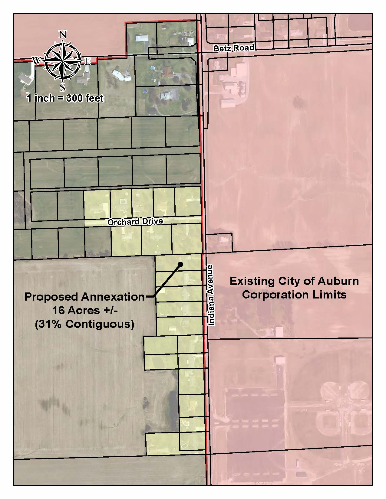 Annexation Map
Back to top
1